Slaughter
29th February 2024Network Rail has been busy cutting down trees beside the Macclesfield stretch of the West Coast Mainline. The result is not pretty and affects a nearby walking route that I often use. Tree trunks have been denuded and left to look lifeless. If life restarts on these, the devastation may be softened, but that is not within sight just yet.
While I can understand that windthrow is a problem for trees next to a railway line during stormy weather, the aftermath of the cutting looked sad to my eyes. Shelter was removed, and it may be that walkers do not need such a clear view of the railway anyway. It all caused a trail that has something of a bucolic aspect to appear more industrial than it used to do.
The time of year hardly helps, with all the leafless trees and bare ground after the winter. Maybe things will look less brutal during the coming growing season. For now, though, there is a lot of carnage that needs healing. At times, I have had my misgivings about tree cover when seeking photos of scenic spots, yet that is not how I feel about this ongoing aftermath.
Consolidation
27th February 2024The magazines Cumbria and Lakeland Walker have been combined, a move that makes me wonder about the wisdom of remaining a subscriber. The strictures at the height of the pandemic saw me subscribe to a number of magazines, mainly to cut down on shop visits and also to contribute to keeping going through a tough time. Lakeland Walker was one of these and had its uses for getting ideas for Cumbrian outings.
Since then, there have been a number of changes. The world has turned against plastic, so many magazines are mailed in paper envelopes, not the best for keeping them dry during some of the deluges that have beset us during the last twelve months. What once was a title printed on A4 paper now is part of a combined title printed on what appears to be A5 paper, an increase from the size of Cumbria magazine, though.
So, we have the perhaps clumsily titled Cumbria and Lakeland Walker magazine. In some ways, the combination is reminiscent of The Scots Magazine, which also has an outdoors section, albeit without maps. Thus, the merged entity can work and there may be a finite number of walking ideas among the Lakeland fells anyway. Only time will tell how things will out for the new title and if I remain a subscriber, for there can be too many magazines and not enough time to read them all.
When promised sunshine scarcely appeared
10th January 2023These words are being written in a period of ongoing industrial relations turbulence. Whenever this happens, it can seem never-ending. Hope gets lost, but things can be resolved quicker than anyone can imagine.
Much of 2018 was blighted by Saturday-only stoppages that affected Northern Railway. It meant that outings were limited for me because I do not drive a car. In fact, they were an impossibility for many of the places that hill wanderer would go in the north of England. Thus, when the stoppages were halted, it was as if I was unleashed to take advantage of the restored sense of freedom.
Trips to the North York Moors and Derbyshire preceded two outings to the Yorkshire Dales. This piece describes the first of the latter, when sunshine was scarcer than predicted in the forecast. That encouraged another that will be described in a later posting.
The lack of sunshine necessarily limited the number of photos that I made on this trip, so figuring out the route again took some doing. Nevertheless, I reckon that I have recalled it. Recording GPS tracks or even filming hikes is something that I have avoided so far, but that needs a rethink unless I stop leaving it so long before writing trip reports.
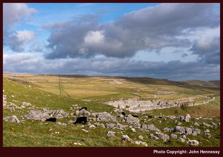
On the day, I made my way from Settle’s train station towards Castlebergh Plantation. From there, I followed the Pennine Bridleway in the direction of Malham Tarn. That meant passing the turning for the crags that may have lured me out that way in the first place. They would be passed on the way back.
Everywhere lay under grey skies as I followed the track towards Langscar Gate and Malham Tarn. A young walking group was going this way too, so I dallied to give them time to move along for the sake of added solitude. Following the broad track appealed to me, as these so often do, especially when quietude can be found. That made up for any lack of sunshine.
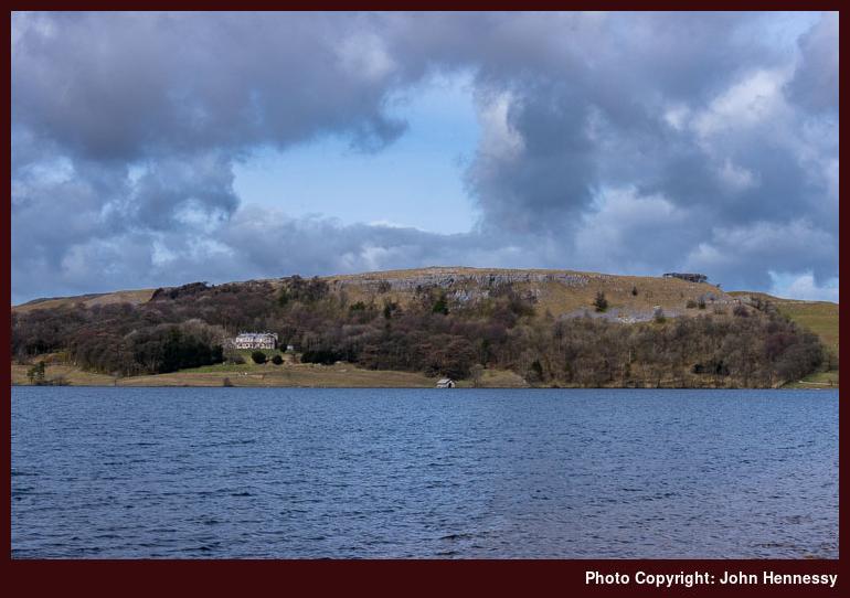
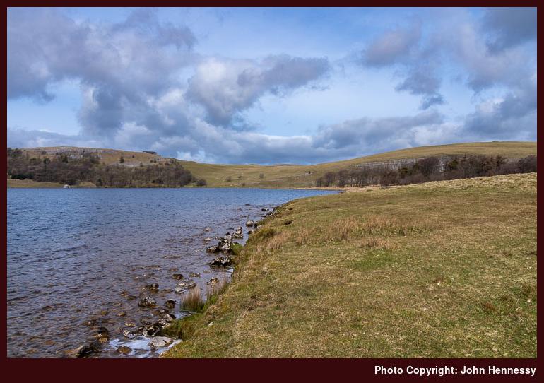
Skies partially cleared of cloud around Malham Tarn, somewhere that I possibly had not visited for more than ten years. That made me linger and attempt a spot of photographic capture. The results may have been incompletely in their success, but they were proof that I was not totally out of luck. Now that I think of it, there may have been more sunshine available than I had thought.
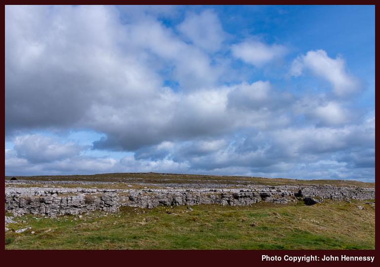
My next move was to make for Malham village. That took me past Broad Scars and Malham Lings before I returned to tarmac again. Descending by Malham Rakes gained me views over Malham Cove as well as getting me to the village where I enjoyed a refreshment stop.
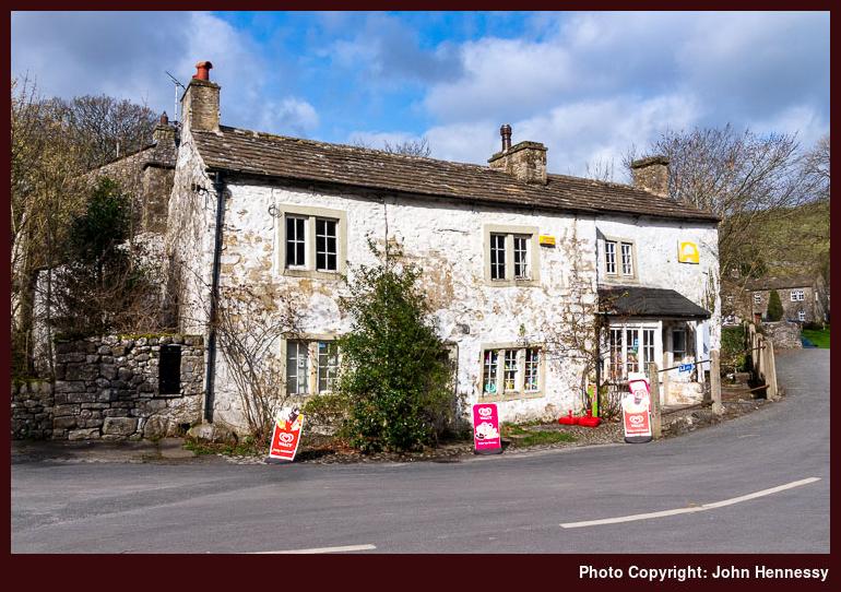
The shop was looking more tatty on the outside than when I was near there on previous visits. The paintwork was wearing off the stonework and the shopkeeper looked aged, which have explained the lack of maintenance to the outside of the building. Skies again broke to allow some sunshine, and I took in sights of the cliffs of Malham Cove on the next stage of my hike.
My return to Settle took me near Town Head as I made my way onto Long Lane. That kept me off Cove Road until just before a steep ascent, after which I left the road for a public footpath that would take me back to the Pennine Bridleway near Kirkby Fell. There was empty countryside around Rye Loaf Hill, though I seem to recall seeing some mountain bikers around there.
More civilisation in the form of Stockdale Farm before I left the lane to follow the Dales High Way past crags that I had fancied photographing. The grey gloom put paid to that ambition, so I reconciled myself to enjoying the hike instead. There was one last uphill heave before the final descent into Settle, which felt very distant in the vicinity of the limestone outcrops that I was passing.
Another visit would be needed to make photographic use of the scenic delights that they offer, but the walk had left me content. There may have been a refreshment stop before I started on my train journey home in the knowledge that there was some unfinished business that remained in this part of the Yorkshire Dales. A return would follow.
Travel Arrangements
Return train journey between Macclesfield and Settle, with changes at Manchester Piccadilly and Leeds.
A break from Christmas preparations between Grindleford and Sheffield
27th December 2022The lead up to Christmas this year was very gloomy. After all, economic fortunes were heading downward and many have been on strike. The weather did not help either, and I was feeling exhausted after a year of some emotional toil. The cause has been the initiation of significant changes to my affairs in Ireland. Some will be sold and a lot of preparation is needed, some of which is going slower than is ideal. All this has weighed on me because my life has not been here before now.
One result is that Christmas preparations did not happen as early as one would have liked. The other is that I did the bare minimum for a time of year whose meaning changed with the passing of my parents. It all crept up on my as well. Now, I am hoping for an extended period of rest so that my energy levels get recharged again.
2018 was different. There was a trip to Ireland at the end of November, which meant that I had a clear run at Christmas. Some dental treatment became necessary too, and there was to be a mid-winter break on Tenerife as well. All added a frisson of tension to that moment. In many ways, it was a time of hope.
All it took was a sunny interlude to allow me to make use of an idea from a previous trip. It was enough to get me to Grindleford for another station to station walk to Sheffield. The first part of the hike was to ascend through trees to the side of the B6521. After a little way around the road, it was time to drop down through Yarncliff wood to the banks of Burbage Brook. This descent was steep enough to warrant greater attention at times.
Following the brook took me out of the tree cover and towards Burbage Bridge. Reaching the A6187 meant going through more woodland, meaning that views were restricted and that my camera was mostly inactive. This being a Sunday, there were others around at times, though numbers were never oppressive and there was plenty of solitude as well.
Crossing the road got me onto the Sheffield Country Walk, with views of surrounding moors catching some of the available sunlight. Higger Tor was among these, and there was an antiquity too in the form of Carl Mark Fort. The idea of continuing north might have appealed by for my designs on reaching Sheffield in more daylight than my previous amble in that direction. Even now, it tickles my sensibilities to think of passing Burbage Rocks and to reach Stanage Edge, closing the chain as it were.
On the day, I picked up a path leading to Houndkirk Road. On reaching the intended byway open to all traffic, I was trading solitude for the bustle of multi-modal usage. Dealing with other walkers along with cyclists and runners is one thing, but I was somewhat aggrieved by the sight of off-roaders engaged in green landing. That caused some clutter as I made for Ringinglow.
All such annoyances were left behind me, though; it helps when there are some quiet stretches that soothe your spirit. From Ringinglow, I made as if to head directly towards the outskirts of Sheffield, only to leave the road for a public footpath dropping me onto Clough Lane. This was my return to the banks of Porter Brook, albeit omitting Porter Clough this time around.
While I do not seem to have the photos to prove it, daylight was to persist all the way to Endcliffe Park for me at the second time of asking. There was some ice underfoot too, but this was no intrusion on progress. Neither did it prematurely force me onto city streets, so a little more closure was my lot before I mustered my wearying limbs for a meandering course to Sheffield’s principal train station.
The general run of weather may explain the dearth of photos accompanying this piece. It so happened that the hike returned me to Sheffield for the second time in two days. The second encounter was drier than a preceding shopping excursion beset by rain. Rain was also to await my return to Macclesfield after the walk, proving a point about what I had snatched during an otherwise unsettled run of weather.
Getting better photos remains a motivating factor that adds an idea for a visit to Sheffield’s more natural surroundings when an opportunity allows. It is as if you never can say that you are done with anywhere. The same could be said for a Grindleford to Hathersage station to station hike. Some places just cannot but offer more and more ideas for walking trips.
Travel Arrangements
Outbound train journey from Macclesfield to Grindleford with a change at Manchester Piccadilly. Return train journey from Sheffield to Macclesfield, changing either at Stockport (faster train) or Manchester Piccadilly (slower one); the journey is lost to my recollection now, but my sense is that I would have gone via Stockport for sake of speed and convenience.
From Hathersage to Sheffield with clag abounding but not obstructing
26th December 2022In many ways, this hike follows on from the last one that I did in 2017. It was the first of a pair of moorland rambles that finished in Sheffield city centre in darkness. The second one started from Grindleford to make the most of the shorter hours of December daylight, while this one began from Hathersage to fulfil a possibility that was spotted on that 2017 outing and followed part of the Sheffield Country Walk next to some appealing crags.


The way out from Hathersage shadowed the end of the previous hike. Because of declining light, that had made use of Coggers Lane after Denis Knoll for the sake of easier navigation; my memories of this are that it was quiet because motorised traffic went elsewhere from the car park at Denis Knoll. The views were available to a point at the start, but I entered Hathersage in darkness. This time around, I followed the off-road Baulk Lane on a course that took me to Green’s House via Brookfield Manor and Brontë Cottage.

My passing Green’s House was reminiscent of a walk that I undertook more than fifteen years before. Then, I was also bound for Stanage Edge, but I believe that I went north that day and returned to Bamford via Ladybower Reservoir. The walk may even have begun from Bamford, though the mists of time somewhat fog up certainty on that matter. There was even a photo in the online gallery of this website for a time that recalled this, and the approach was from the west back then.


This time around, I came to green’s House from the south and continued past it to the north, and not the west like the previous time. All the while, sunshine was coming and going, as it had been all day. There was a hazy feel to long-distance views too, with things looking a little claggy from time to time. There also was a piercing east wind, so that also ensured that I kept moving.


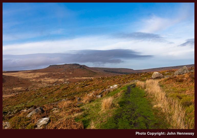
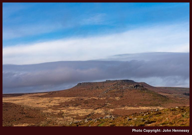
After Denis Knoll, I was retracing some of the steps that I traipsed the year before. The light was stronger because of the earlier time of day, and the views beckoned me forth. Buck Stone was passed, with Stanage Edge coming ever closer. As I approached, I surveyed the views that lay about me.


My lure was Long Causeway, a clear track that led through the crags of Stanage Edge. Tracks like this always appeal to me, so long as there is not too much multi-modal usage. This time around, that was not the case, so I could enjoy what surrounded much like I do on such things in Scotland.

The track took me past Stanedge Pole before dropping down to Redmires Reservoirs. The day was advancing, and I needed to be determined if I were to get to Sheffield. There would have been a time when I might have reconsidered my plans, but there was always the fallback of using a head torch later if needed. There was quite a way to go yet.


To get to Fullwood Lane, I made use of concessionary paths that were more boggy than that on which I had been travelling. There was some added route finding too as I veered around by White Stones. Nevertheless, I returned to tarmac and set to finding the path leading down to Porter Brook. Now, my course to the heart of Sheffield was largely set.
Light was declining noticeably by then, though, and that took away a little from the enjoyment that I might otherwise have gained. The banks of the watercourse felt wilder than I might have expected. The other surprise was how many were making use of the amenity that late in the day. It was not just stragglers like myself who were pottering about in the dusk. The attraction of more natural surroundings must defy any lack of light for them.
The trail does finish up in Endcliffe Park, and the increasing darkness caused me to bail out around Hanging Water. The rest of the way had me shadowing Porter Brook under street lights with by now tiring limbs. Beyond Endcliffe Park, it was a matter of making for the city’s train station. This was not as easy as walking along the banks of a stream, since improvements for motorised traffic add deflections to any sense of a direct course.
It had been a Sunday filled up with a station to station walk and many delights. If I had been more motivated or less occupied by other matters, I might have got out on Saturday instead. That might have meant an earlier start (trains start later from Macclesfield on Sundays) and hence better lighting on the Sheffield section of the amble. Instead, I was pondering another way to do just that. What was filling my mind was the prospect of another station to station walk: Grindleford to Sheffield. With shorter days, that shorter course might mean that I would not have needed to wait too much longer. In the event, it did not, and that is the next trip report that needs doing.
Travel Arrangements
Outbound train journey from Macclesfield to Hathersage with a change at Manchester Piccadilly. Return train journey from Sheffield to Macclesfield, changing either at Stockport (faster train) or Manchester Piccadilly (slower one); the journey is lost to my recollection now, but my sense is that I would have gone via Stockport for sake of speed and convenience.