A new GPS receiver
18th June 2016Most if not all articles written about outdoors gear usually do not contain any mention of life circumstances yet they pervade this one. To me, January 2015 brought a life changing event whose alterations still are ongoing. My father’s passing away last year and that of my mother years nearly two years before then now make for a very changed set of circumstances. Not having to deal with my father’s fear of flying has meant that I can countenance overseas excursions like those that took me to Iceland and Switzerland last year together with Austria a few weeks ago.
Motivation & Opportunity
If it were not for last year’s trip to Iceland, I may never have acquired a GPS receiver. Apart from an abortive attempt to buy a Magellan eXplorist 100, it stubbornly remained on the nice-to-have section of any gear wish list since I never got to spending the outlay. It was exposure to the shortcomings of maps with a 1:100000 (1 cm per 1 km) scale on a walk around Landmannalaugar that finally convinced me to try again. Even with a subsequent trip to Switzerland and perhaps because of what I spent on accommodation, travel and other things, the acquisition that had to wait.
The deed itself was done in circumstances that one might have expected to produce a different set of priorities for it was in the time around last Christmas. My plan was to spend Christmas itself in Britain before heading to Ireland for a few days and returning before New Year’s Day. That didn’t happen for emotions just were too raw and I rearranged the trip for sometime in January. What had added to my melancholy was how things went during Christmas 2014 when a neighbour of my parents went about planning Christmas 2015 when all I wanted to do was get into 2015 and leave 2014 after me. Now Christmas has lost all its child-like allure for me, I tend to want to get past it rather than bringing the next one closer.
Not travelling to Ireland at the end of 2015 meant that I could get past last Christmas and leave it after me to grow smaller in the rear view mirror of life. Doing otherwise would mean lugging too much emotional baggage through 2016 and that was why that 2014 invitation hurt me as much as it did; that Christmas was one that I needed to leave after me. The extra time at home was put to good use too for I embarked on a tidying spree that result in so many bin bags of items for disposal and recycling that it too a few weeks to clear them. Aside from the last Tuesday of the year or the afternoon of Christmas Eve, the weather had not been so enticing anyway and it felt like pathetic fallacy that so much rain fell and the winter generally was a rain-drenched season anyway.
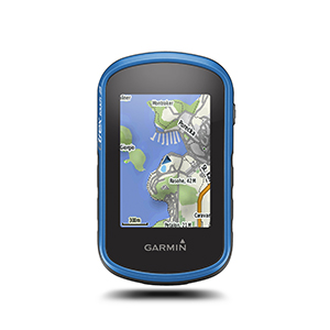
Having bailed out of the planned Irish trip on St. Stephen’s Day, or Boxing Day as it is known in the U.K., I decided to book the purchase of the long-windedly titled Garmin eTrex Touch 25 from Go Outdoors’ Manchester branch. Perusal of a newspaper on the way there revealed just how miserable some people’s Christmas had been for they were physically flooded while I was emotionally so; the Calder valley had been very badly hit by the weather and they were not alone.
Early Testing
Time elapsed before I got to testing out the new gadget and there is more I have yet to get it to do even now. That Christmastime Tuesday trot around Macclesfield that took in Tegg’s Nose and part of the Gritstone Trail depended on my local knowledge and a paper map instead. Testing the new acquisition in earnest was take until the second week of 2016 and various opportunities since then have seen it left at home so I am far from developing a dependence on the device. These have included a recent walk from Tideswell to Hathersage via Litton, Foolow and Eyam as well as a subsequent one from Leek to Macclesfield that took in the Roaches as well as Tittesworth Reservoir, Gradbach, Wildboarclough and Higher Sutton.
Still, it has been taken outside a good few times. These mainly have been on trots about Macclesfield that include some soggy ones earlier in the year and drier ones more recently. It also has made it to West Limerick in Ireland, Stirling in Scotland as well as Innsbruck and Zillertal in Austria.
As the word “Touch” in the name suggests, this is a touch-screen device and my attempts to keep the screen reasonably clean mean that I use a stylus with it like I do with a phone or tablet. Starting it up brings you to a screen for one of its numerous modes. So far, I have stuck with the hiking one and there is another customised version of this that I created but there others for various forms of cycling as well as hunting, fishing, climbing and geocaching. It is only the hiking modes that I have tried so far but one of the cycling ones (bike, tour bike and mountain bike) could be a possibility yet.
In my experience, this is not a device for spot reading of where you are but one that tracks where you are going. Given that it shows a map underneath, that does help when you are unsure of things though battery usage then becomes a concern as does remembering to enjoy what surrounds you, which is what gets us out and about in the first place anyway. Going about the place staring at a small screen rather defeats the point of exploring the countryside and could cause an accident. As for battery life, my unit is on probation with disposable batteries until I can be sure that rechargeable ones are not getting discharged too quickly.
Available Maps
By default, the Garmin comes with its own maps for eastern and western Europe. For places without alternative coverage like Iceland, these are a good substitute for the walking maps that are available. In fact, having the gadget with me around Landmannalaugur last year would have been a big help for it shows that trail at higher magnification than the 1:100000 scale map that I was using at the time.
However, there are other maps available with the BirdsEye Select series offering 1:25000 Ordnance Survey data for Great Britain as well as its equivalents for France, Germany, Switzerland and Austria (including part of Italy). Holiday destinations like Madeira, the Balearic and Canary Islands together with the Azores see inclusion in this series too. Along with the OS, data come from Kompass, France’s IGN and Germany’s BKG. The advantage of these offerings is that you choose the area for which you buying maps and no the selection decided for you by a provider. Garmin offers other series and there is a one called BirdsEye that appears to do the same for the U.S.A. and Canada.
To get coverage beyond the aforementioned countries, you need to look at Garmin’s other offerings. These differ from the above in that these are preselected areas rather than self-selected ones from the BirdsEye series and cost more for higher definition maps because of the amount of coverage that is included. For Great Britain, there is the Discoverer series and both TOPO US 24K and TOPO US 100K series just cover the U.S.A. Country coverage for the other mapping series (there is one in the BirdsEye range for satellite imagery but I am less interested in that) is below.
TOPO PRO:
France, Germany, Switzerland, Austria, Czech, Finland, Spain, Belgium, Luxembourg, the Netherlands, Slovenia, Croatia, Bosnia and Herzegovina, Serbia, Kosovo, Montenegro, Macedonia, Albania, Norway, Sweden, Angola, Botswana, Lesotho, Madagascar, Malawi, Mauritius, Mayotte, Mozambique, Namibia, Reunion, South Africa, Swaziland, Zambia, Zimbabwe and Denmark.
TOPO:
U.S.A., Canada, Australia, New Zealand, Spain, Slovakia, Bulgaria, Tunisia, Hungary, Mexico, Chile, Norway, Argentina, Bolivia, Morocco, Greenland, Austria, Belgium, Croatia, Czech, Denmark, Estonia, Finland, France, Germany, Great Britain, Greece, Ireland, Italy, Latvia, Lithuania, Luxembourg, Malta, Netherlands, Poland, Portugal, Romania, Slovenia, Sweden, Switzerland, Algeria, Angola, Benin, Botswana, Burkina Faso, Burundi, Cameroon, Cape Verde, Central African Republic, Ceuta, Chad, Comoros, Côte d’Ivoire, Democratic Republic of Congo, Djibouti, Egypt, Equatorial Guinea, Eritrea, Ethiopia, Gabon, Gambia, Ghana, Guinea, Guinea-Bissau, Kenya, Lesotho, Liberia, Libya, Madagascar, Malawi, Mali, Mauritania, Mauritius, Mayotte, Melilla, Mozambique, Namibia, Niger, Nigeria, Republic of Congo, Réunion, Rwanda, São Tomé und Príncipe, Senegal, Seychelles, Sierra Leone, Somalia, South Africa, South Sudan, Swaziland, Tanzania, Togo, Uganda, Western Sahara, Zambia, Zimbabwe, Bahrain, Ceuta, Gaza, Iraq, Israel, Jordan, Kuwait, Lebanon, Melilla, Oman, Qatar, Saudi Arabia, United Arab Emirates, Westbank, Western Sahara and Yemen.
TOPO Light:
U.K., Ireland, Australia, New Zealand, Finland, Belarus, Israel, Poland, Portugal, Turkey, Romania, Burundi, Djibouti, Eritrea, Ethiopia, Kenya, Rwanda, Somalia, Sudan South, Tanzania, Uganda, Turkey, Romania.
Aside from the BirdsEye range where the Basecamp PC or Mac software is needed, maps can be purchased and downloaded to your device from the website. However, the browser plug-in does not work in the current versions of Firefox or Google Chrome at the time of writing because it has not been digitally signed by Garmin. On Windows PC’s, that leaves Internet Explorer as the only option and I needed to try it more than once to ensure that Basecamp registered the new map. Finding out what happens with Safari is not something that I have got to doing yet but it is a possibility.
Storage
With all the downloadable data, it is just as well that the eTrex Touch 25 takes a microSD card; the default maps and software leave just over 2 GB free out of the 8 GB of internal storage. The slot is in the battery compartment underneath the batteries and I have added a 16 GB one. If needs extend beyond that, a bigger one can be added in its place. It is possible to buy data on SD or microSD from Garmin so there could be the temptation to use one of these in the same slot. A limited number of packages come on DVD and I wonder how they get transferred, even if this is a legacy format nowadays.
Software
Sessions exploring the available computer software followed suit and Garmin’s BaseCamp is what’s needed for managing any data. Exports to GPX files meant that routes could be seen in Mapyx Quo and Anquet’s OMN too.
Please be aware that comment moderation is enabled and may delay the appearance of your contribution.