A frosty February day spent around Rothbury
26th September 2020Photographic equipment errors can blight subsequent results. For instance, this summer saw me using a camera at a different ISO setting to what was intended and I did not notice it for weeks. Given that the setting was 320 rather than the desired 400 and I have often mulled over the idea of using 200, it was not a calamity given that I create raw image files anyway.
What reminds me of the above is that a more obvious mishap beset the photos made on the trip described in this report. That time, I somehow knocked the camera into the wrong daylight balance setting. All the images came out far too red but creating raw image files allowed for a rescue in Adobe Photoshop Lightroom. Being able to bulk copy the new settings was a real bonus so I could ameliorate any annoyance in the act and leave the lesson on file for future reference.
Given I finally had got to Rothbury after having designs on such a trip for what seemed light an age, the easy fix to those photos probably was just as well. Just like the North York Moors that were featured in an earlier post, this too was a long way to travel for a day trip, though that never stopped me getting to other parts of Northumberland since they are afflicted by the same disadvantage.
Rothbury was reached later in the same week as an icy encounter with Roseberry Topping. The chance of a bright day added to the required motivation input even after an outdoors escapade earlier in the week, especially since an early morning start was needed. It also was good timing for travel by double-decker bus for the last part of the inbound journey.
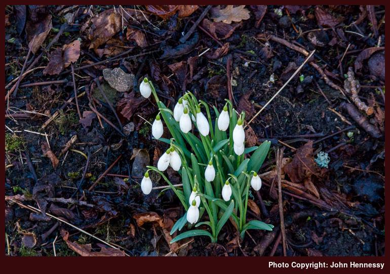
Though Newcastle was dull while I was passing through the city, Rothbury was bright and sunny with clear blue skies overhead when I arrived there. My intended walking target was Simonside so I soon left by way of St. Oswald’s Way to make the most of the time that I had. The day may have been laden with wintery crispness but I was to pass a harbinger of spring once I passed Whitton: snowdrops.


After passing Sharpe’s Folly on my way towards Hillhead Road, the surrounding views opened as I followed the track with height being gained as I did so. Though looking to my left brought my eyes towards pleasing sights, it was what lay to my right that captivated my attention at various points throughout the day. The white-topped summits of the Cheviots not only acted as a reminder of winter but also contrasted against the otherwise green landscape bedecked with some brown patches.
The track was left to reach Whittondean and going beyond that took me onto open moorland. Handily given that I was crossing soggy bogland, the path was paved. All the age of my map was plain to see so it was just as well that I had the OS Maps app on my phone for adding the extra details. Quite why I had not got around to buying a newer paper map is lost to me but it would have added the route of St. Oswald’s Way for one thing.
At that time, thoughts of depending on a phone app given the vagaries of signal and battery life felt imprudently trusting. Still, it all held together on the day and even showed another public footpath over Simonside that itself came in being after 2005, the publication date of my Explorer map. Since then, I have chosen phones with lengthy battery life and they came into their own during this year’s travails when they allowed me to leave paper maps at home for various local day hikes where I largely know the lie of the land anyway. Still, I am mindful that the phone is doing the locating so I need not lose that ability for myself in case I ever need it again. After all, devices are not that infallible.


A relatively timely arrival at the eastern end of the Simonside ridge added a certain complacency about route timing that soon got dispelled by the false summits that I met along the way. The whole section may have been around three kilometres in length, but the afternoon passed as I pottered from east to west, especially given the arresting views that lay all around me. Winter whitening of various sections and the presence of icy patches added to the need to concentrate on what was at hand. That really applied to the steep western descent from the actual summit itself.
By then, it was late afternoon and I needed to catch a bus at a certain time too. Even with this and with others going the way, I was not going to rush, but any coated patches were left after me soon enough along with any gathering of humanity. Then, it was a matter of descending through forestry to Great Tosson, an act greatly aided by the use of walking poles to speed things though there was ample time to survey the surrounding scenery as well.
From Great Tosson, there was a road descent to Newtown, after which a byway returned me to the banks of the River Coquet. Once across to the other side, I was bound for the bridleway taking me back to Rothbury again. That the sun continued to lower in the sky caused no concern given the progress that I was making. A lost time had been made up again without the need for rushing; it was all a matter of maintaining a steady if unhurried pace while relishing what lay about me.
In fact, there was enough time before my bus came to visit a shop for some provisions and a new map of the area. After that, my journey home began and I could wonder about returning to Coquetdale. Though current circumstances may delay that, I still have spied a possible route taking in Cartington Hill and the Cragside Estate. Having an excuse to revisit a place never is a bad thing to have.
Travel Arrangements
Return train journey between Macclesfield and Newcastle extended by a return bus journey on route X14 between Newcastle and Rothbury.
Please be aware that comment moderation is enabled and may delay the appearance of your contribution.