Category: Europe
A bitter blustery day on Moel Famau
Though there were plenty of things on my mind, like executing my next career moves at the end of a long break, times certainly were simpler in February 2018 than they are now. Personal income was reduced heavily but I also controlled expenditure far better. Also, time largely was my own so I could pop out on day trips whenever the weather allowed, so a sunny day was enough to lure me to Moel Famau, a place on which I had designs for more than a decade. A weekday excursion allowed for better public transport options so the previous stymied trip idea became a real outing.

Ironically, the trip that never happened was inspired by a bus timetable leaflet then produced by the now defunct Cheshire County Council. Instead, I was to encounter other parts of the Clwydian Range on a hike from Denbigh to Ruthin and on another that carried me from Llangollen to Wrexham when Ruthin seemed too far to reach that Sunday evening. Belatedly after those, I was not only to encounter the Clwydian Range but actually potter along part of its length.

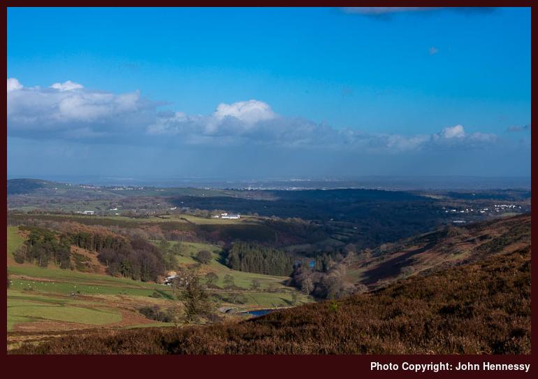
My timing also coincided with a school midterm break and Loggerheads Country Park had attracted families, but simply continuing on my way was enough to leave them after me. Given that there were many other spots that granted me more in the way of the solitude that I so relished, that was just as well. To get closer to those, I just followed the River Alyn as it flowed past limestone outcrops and was completely unaware that, behind them, most of the hill of Cefn Mawr was eaten up by a quarry. It just goes to show, that even in Wales, limestone country can hide such a thing.
The full revelation of the extent of scarring left on the landscape by Cefn Mawr Quarry needed some height gain and that was ahead of me if I wanted to reach the top of Moel Famau. Before that though, I remained by the banks of the River Alyn until I left the track to cross the river and some muddy fields to reach Bryn Alyn. There was a road-based route that would have taken me around by Bryn y Castell but I fancied keeping that to a minimum at this stage, possibly a good idea since so much tarmac travel was to occupy the end of the day's walking.
Nevertheless, continuing uphill from Bryn Ayn on a minor road was needed to get me onto a bridleway that would round Ffrith Mountain and get me most of the way to Moel Famau. As I continued along the track, height was gained all the way and views of the surrounding landscape opened out before me. Much was pastoral and the size of Cefn Mawr Quarry became more and more apparent; most of the hill seemed to be gone!
Leaving sights of environmental sacrilege after me, I rounded the boundary of Clwyd Forest to reach the summit that I was seeking. While the bridleway got me most of the way there, I left it to make the final approach to the Jubilee Tower. As if to remind me of the season, a brief flurry of snow came upon me, but the lasting impression is of the stiff and bitterly cold wind that blew along the ridge.

That did not deter me or the others who were there, but this was not a day for lingering, especially with a wind that could knock you. Still, the tower dating from the reign of Queen Victoria was explored before I started to descend along Offa's Dyke Path. Conditions underfoot were greasy enough for walking poles to prove unable to halt a muddy tumble. After that, more careful travel was in order, yet my sure-footedness was not guaranteed even then.


Even with plains abutting the eastern and western edges of the chain of hills, it still was possible to make images that could make one believe that it was more extensive than it was. There was so much scope for that choosing photos for this trip report was an exercise in itself. All the while, the afternoon was edging towards its end so I needed to think about getting to Mold before it got too dark. Before that, I had plenty of moments full of uninterrupted quiet and had ensured that by continuing from Moel Famau to Moel Dywyll after seeing a sizeable group of walkers taking a route that I might have taken. Peaceful wandering was what I sought and there was plenty of that so it often does no harm to let others decide some things for you.
After Moel Dywyll, I found the bridleway that started me on my descent. However, greasy ground turned out to be my undoing as I endured my second muddy stumble of the day. That caused some muttering about my falling into a somewhat carefree mood, but this was the last of these and I continued on my way without anyone seeing my blundering and with added care in spite of the alluring late evening sunshine. The shelter afforded by the valley was all the more appreciated as I passed Garth and two reservoirs on my way to Pentre.
While a side-trip to Cilcain tempted me, weary limbs and declining light informed my decision to follow a stream-side public footpath by Nain Gain instead. After that, it was road walking all the way to Mold's bus station. Along the way, there was another crossing of the River Ayn and I passed such smaller places as Pontnewydd, Pantymwyn, Gwernaffield and Pant-glas. Light really was fading by then but I got within the street-lighting area in good time and reached the bus station as I hoped, so my journey home started after a satisfying day in the hills laden with soothing quieter moments.
Travel Arrangements
Return train journey between Macclesfield and Chester. Bus service X1 from Chester to Loggerheads where my walk started and, when It ended in Mold, bus service 4 was used to get from there back to Chester train station.
Visual treats
Over this weekend, I have been watching Life of a Mountain: Helvellyn on Vimeo. That meant renting the title for 24 hours at a cost of £7 and I have a copy of the DVD on order from Striding Edge too. The latter action was a result of watching the online version though I somewhat mourn the loss of SteepEdge where I used to buy digital versions of such wares.
The film was made by Terry Abraham and is the last of a trilogy concentrating on best loved Cumbrian fells. Scafell Pike and Blencathra have featured before now and I have copies of those too. The latest installation is long with a running time of nearly two and a half hours but it is packed with such visual delights that the length is deserved. This still feels a much tighter and less padded out piece of work. The others had me going back to The Cairngorms in Winter with Chris Townsend, Abraham's first accomplished effort and he also has shorter films introducing parts of the Lakeland Fells.
The Helvellyn film re-uses contributors from earlier films like Alison O' Neill, David Powell-Thompson, Stuart Maconie and Mark Richards but there is a host of other new ones like Peter Gibbs, Mary-Ann Ochota and Julia Bradbury among others. Even the Royal Air Force and Ordnance Survey get included. They all complement the backdrop of dramatic scenery accompanied by a stirring soundtrack, especially the action sequences involving the RAF, skiing down to Red Tarn from the summit of Helvellyn or paragliding off the same starting point. That the footage came from a time before the present pandemic was a reminder of how things should be.
The whole combination has re-ignited a desire to walk around Helvellyn that has lain dormant for too long. What that needs is determination and opportunity to accompany ongoing patience needed by the course of the ongoing pandemic. After all, I have visited Patterdale and Ullswater a few times now and they were so heavily featured in the film that I at the time wondered if it was about them and not very much about the mountain (that probably is what happens when you need include something on the lives of people living in the area). Nevertheless, 2020 did not involve a Lakeland visit for me so a return is not before time and having a lure to draw you through darker times has to be a good thing.
A year when an unwanted adventure arrived
We live in a time when all sorts of activities are being sold as adventures. Even a day hike falls into scope for this yet I do not need such branding to make me take advantage of such a possibility. A day with good weather spent in the midst of hill country or along a scenic coastline will do the job for me equally as well. In fact, it has been sufficient sufficient for longer than I care to recall.
2020 has been full of those in spite of the threat that it brought our way. They may have been near home for much of the time so it is just as well that I can walk into nearby hills from the front door of my own house. Long circuits taking in Shining Tor, Cheshire's county top, along with Croker Hill, Bosley Reservoir and a host of other nearby landmarks saw me begin a summer of longer walks.
Some took me back home from a starting point reached by public transport. These included such places as Buxton, Knutsford, Disley and Whaley Bridge with the second entry on that list being the longest of the lot. The weather was mainly fair too apart from the occasional wetting.
Getting a little braver took me a little further afield. For instance, there were tow long hikes between Leek and Buxton, something that lay in my ideas shelf for far too long. Day trips to Church Stretton in Shropshire and Llandudno in Conway became the limits of my perambulations for the year before a cold weather walk from Hayfield to Chapel-en-le-Frith bookended things and an autumn of lockdown, less enticing weather and an indoor learning project became my lot.
Still, good memories got made in spite of the pandemic and these even included visits to Sheffield that I am not enthused about doing at the timing of writing these words. The hills may have been smaller but the wandering got me away from humanity even if more found their local countryside this year than ever before.
While 2021 lies ahead of us, it is difficult to plan ahead right now. There has been an upsurge in the number of cases of COVID that needs to abate and it does feel that vaccination cannot happen fast enough. This may may the darkest hour before a new dawn but I plan to get to a brighter future before making too many plans.
Of course, we still can dream. This time last year, I was pondering which part of the U.S. to visit during the summer months. After reading about the states of Washington, Oregon, Wyoming , Montana, Colorado, I settled on the last of these and that remains on the ideas shelf. The Azores are found on there as is the possibility of Madeira and locations nearer home appeal too.
Webinars from Wanderlust as well as the Adventure Travel Festival all fuelled my imagination though dreams of round the world motorcycle or walking trips remain out of the question. It remains good to hear the stories of other explorers' exploits though and they help to brighten what has been a dark time for many of us.
My book reading continues in much the same vein as I sit out the necessary period of time that is needed for things to settle again. Patience is much required by those of us able to stay safe while we think of those not in such a fortunate position. Adventures can take their toll and this one certainly has so we only can await the prospect of happier ones should they come out way.
Subscriptions and home deliveries
This has been an exceptionally tough year for retail and hospitality businesses and it is not over yet. In fact, it looks as if the start of 2021 may be no better. My line of business differs from these so I am one of the lucky ones in many respects since I have been able to work throughout the whole episode. Even then, I have not been immune from the added tension of the times in which we find ourselves.

That also means that I am not doing many of the things that I normally would be doing. International travel needs to wait as does staying away from home. The fact that town centres got too busy for my sense of personal safety has had its own effects so I avoid them as much as possible. One consequence is that I now subscribe to every magazine that I read aside from ones that I can get delivered whenever their content appeals to me. Going to a bookshop to see what new books are out is postponed because going online does much of that for me. Even with hand sanitiser usage, you never know what you could spread by touching books in shops.
Given all this, I still fancy getting out and about in some hill country when circumstances allow. There is a walk from Hayfield to Chapel-en-le-Frith that I fancy reprising in brighter weather and with warmer clothing, should the day be chilly as we can expect over the next few months. That would allow visits to the tops of Mount Famine and South Head together with a repeat encounter with Brown Knoll. The latter has planted in my mind the possibility of going from Hayfield to Castleton that could take in Rushup Edge along the route. With the way that things are at the moment, that probably needs to wait, but ideas are needed for better times.
Speaking of idea collection, I have been catching up on unread issues of Scottish Island Explorer. In one sense, they have been planting in my thoughts the prospect of a long-overdue return to the Western Isles and Arran together with other unvisited islands along Scotland's western seaboard call too. After those, there are the nation's Northern Isles that have been on my radar only for other destinations to draw me to them instead. It is good to stock up with hope in the knowledge that some challenging months lie ahead, and my ongoing reading may add more to these.
A frosty February day spent around Rothbury
Photographic equipment errors can blight subsequent results. For instance, this summer saw me using a camera at a different ISO setting to what was intended and I did not notice it for weeks. Given that the setting was 320 rather than the desired 400 and I have often mulled over the idea of using 200, it was not a calamity given that I create raw image files anyway.
What reminds me of the above is that a more obvious mishap beset the photos made on the trip described in this report. That time, I somehow knocked the camera into the wrong daylight balance setting. All the images came out far too red but creating raw image files allowed for a rescue in Adobe Photoshop Lightroom. Being able to bulk copy the new settings was a real bonus so I could ameliorate any annoyance in the act and leave the lesson on file for future reference.
Given I finally had got to Rothbury after having designs on such a trip for what seemed light an age, the easy fix to those photos probably was just as well. Just like the North York Moors that were featured in an earlier post, this too was a long way to travel for a day trip, though that never stopped me getting to other parts of Northumberland since they are afflicted by the same disadvantage.
Rothbury was reached later in the same week as an icy encounter with Roseberry Topping. The chance of a bright day added to the required motivation input even after an outdoors escapade earlier in the week, especially since an early morning start was needed. It also was good timing for travel by double-decker bus for the last part of the inbound journey.
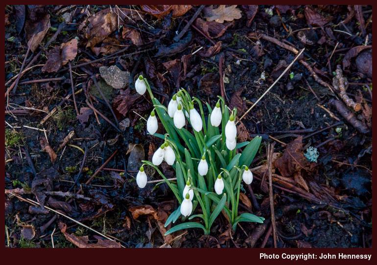
Though Newcastle was dull while I was passing through the city, Rothbury was bright and sunny with clear blue skies overhead when I arrived there. My intended walking target was Simonside so I soon left by way of St. Oswald’s Way to make the most of the time that I had. The day may have been laden with wintery crispness but I was to pass a harbinger of spring once I passed Whitton: snowdrops.


After passing Sharpe's Folly on my way towards Hillhead Road, the surrounding views opened as I followed the track with height being gained as I did so. Though looking to my left brought my eyes towards pleasing sights, it was what lay to my right that captivated my attention at various points throughout the day. The white-topped summits of the Cheviots not only acted as a reminder of winter but also contrasted against the otherwise green landscape bedecked with some brown patches.
The track was left to reach Whittondean and going beyond that took me onto open moorland. Handily given that I was crossing soggy bogland, the path was paved. All the age of my map was plain to see so it was just as well that I had the OS Maps app on my phone for adding the extra details. Quite why I had not got around to buying a newer paper map is lost to me but it would have added the route of St. Oswald's Way for one thing.
At that time, thoughts of depending on a phone app given the vagaries of signal and battery life felt imprudently trusting. Still, it all held together on the day and even showed another public footpath over Simonside that itself came in being after 2005, the publication date of my Explorer map. Since then, I have chosen phones with lengthy battery life and they came into their own during this year's travails when they allowed me to leave paper maps at home for various local day hikes where I largely know the lie of the land anyway. Still, I am mindful that the phone is doing the locating so I need not lose that ability for myself in case I ever need it again. After all, devices are not that infallible.


A relatively timely arrival at the eastern end of the Simonside ridge added a certain complacency about route timing that soon got dispelled by the false summits that I met along the way. The whole section may have been around three kilometres in length, but the afternoon passed as I pottered from east to west, especially given the arresting views that lay all around me. Winter whitening of various sections and the presence of icy patches added to the need to concentrate on what was at hand. That really applied to the steep western descent from the actual summit itself.
By then, it was late afternoon and I needed to catch a bus at a certain time too. Even with this and with others going the way, I was not going to rush, but any coated patches were left after me soon enough along with any gathering of humanity. Then, it was a matter of descending through forestry to Great Tosson, an act greatly aided by the use of walking poles to speed things though there was ample time to survey the surrounding scenery as well.
From Great Tosson, there was a road descent to Newtown, after which a byway returned me to the banks of the River Coquet. Once across to the other side, I was bound for the bridleway taking me back to Rothbury again. That the sun continued to lower in the sky caused no concern given the progress that I was making. A lost time had been made up again without the need for rushing; it was all a matter of maintaining a steady if unhurried pace while relishing what lay about me.
In fact, there was enough time before my bus came to visit a shop for some provisions and a new map of the area. After that, my journey home began and I could wonder about returning to Coquetdale. Though current circumstances may delay that, I still have spied a possible route taking in Cartington Hill and the Cragside Estate. Having an excuse to revisit a place never is a bad thing to have.
Travel Arrangements
Return train journey between Macclesfield and Newcastle extended by a return bus journey on route X14 between Newcastle and Rothbury.