New Year’s Eve rambling on Tenerife, near to Santa Cruz
28th December 2022Photos from a trip often remind me of details that I otherwise had failed to recall. In this case, they take my mind back to a trip to Tenerife four years ago. It was a mid-winter getaway that got me among different hills and mountains with a very different feel because of the geology, the aridity and the vegetation.
New Year’s Eve was the second full day of my trip, and I was out and about along Santa Cruz’s own waterfront, taking stock of what was to be found there and around Plaza de España. What also caught my eye were the hills lying to the north. These were not so high, but their steep sides were unmistakable.

As I surveyed these and other sights, I also pottered out along one of the piers, noticing the famous visitors commemorated on various plaques. What struck me apart from seeing recognisable faces was how Tenerife was a staging post for global travellers before air travel revolutionised such things. Santa Cruz still caters for cruise passengers and there were several ships docked when I was there. It also is where ferries to other islands arrive and depart.
After a trip to Mallorca when fatigue caught up with me, I made sure that I did not overdo things this time around. It meant that the sighting of those local hills acted as a lure and made me act much like I have been known to do around Macclesfield, head out later in the day to spend an afternoon or evening strolling through nearby hills.

From Parque García Sanabria, I walked along Rambla de Santa Cruz before turning onto Avenida de Anaga. After following the coast a little, I turned onto Avenida José Martí. Shadowing the Barranco de Tahodio was taking me in the direction of Parque Rural de Anaga. One thing that I wonder now is if Pico del Ingles was acting as a lure. If it was, that was not how far I intended to walk, even if I did turn around not so far away from it.
In the meantime, I was happy to continue into more natural surroundings. The landscape felt as dry and dessicated as the barrancos that I saw to be without water around Santa Cruz. Seeing poinsettias growing in flowerbeds was striking enough, but the sight of pavements being hosed down and the watering of public floral areas was just as memorable. This is somewhere that gets a lot of dry weather.
My course took me into Valle Luis, and I am unsure if I was trying to get to Embalse de Tahodio and gave up on seeing how it was taking me to get there, or if I overshot my turn onto a hill path. My guess that the first added a little out and back extension to an otherwise circular course. There was someone else around too, and we were eventually to share a few words as we passed each other.

By then, I was following Camino de Valle Luis and shadowing Barranco de Valle Luis. The site of planted poinsettias was being complemented by seeing many cacti growing wild. This was reminding me of the pot plants that my mother had growing in her house. The same warning about cacti applied as much in Tenerife as they did near her kitchen windowsill. My mid-winter escapade was gaining some odd resonances.


There was height gain and loss too, something that was consistent with reaching a high point of 664 metres above sea level. Slopes were dry and the ground dry and dusty, so care on foot placing was in order, even with some paving at times. The ascent was sweaty work in the heat, but there was a distant sighting of El Teide that made it worth the effort as much as the sights that I already was gaining.

As I did so, I was marvelling at where I saw people living and wondering if it was the heat that sent them up to such scarcely accessible heights. Near Galeria los Brezos, I met with walking route PR-TF 2. This took me around by Gollada La Fortaleza, which was my turning point, before dropping me into Valle Seco. This valley was in shadow, so there was not much opportunity for making photos as I shadowed its barranco. Such heights as Roque la Fortaleza and La Muela loomed above me as I navigated a course over uneven ground.
Tarmac was reached soon enough, so the need for concern about foot placement was eliminated. Black plastic pipes carrying water were seen going everywhere as I continued in more populated surroundings. Progress along this part of the walk appeared to be faster than the outbound stretch, and I was on the coast road sooner than I might have expected. After that, it was a matter of retracing my steps to my hotel after what had been an amble in quite different countryside to my normal hinterland.
There was more learning ahead. New Year’s Eve is a big celebration on Tenerife, with many things closed because of the festivities. There was a trip to a shop for some essentials, and I was to wish that I also got something to eat before things got going for the night. In the event, everything worked out and New Year’s Day was to see me go further afield.
A break from Christmas preparations between Grindleford and Sheffield
27th December 2022The lead up to Christmas this year was very gloomy. After all, economic fortunes were heading downward and many have been on strike. The weather did not help either, and I was feeling exhausted after a year of some emotional toil. The cause has been the initiation of significant changes to my affairs in Ireland. Some will be sold and a lot of preparation is needed, some of which is going slower than is ideal. All this has weighed on me because my life has not been here before now.
One result is that Christmas preparations did not happen as early as one would have liked. The other is that I did the bare minimum for a time of year whose meaning changed with the passing of my parents. It all crept up on my as well. Now, I am hoping for an extended period of rest so that my energy levels get recharged again.
2018 was different. There was a trip to Ireland at the end of November, which meant that I had a clear run at Christmas. Some dental treatment became necessary too, and there was to be a mid-winter break on Tenerife as well. All added a frisson of tension to that moment. In many ways, it was a time of hope.
All it took was a sunny interlude to allow me to make use of an idea from a previous trip. It was enough to get me to Grindleford for another station to station walk to Sheffield. The first part of the hike was to ascend through trees to the side of the B6521. After a little way around the road, it was time to drop down through Yarncliff wood to the banks of Burbage Brook. This descent was steep enough to warrant greater attention at times.
Following the brook took me out of the tree cover and towards Burbage Bridge. Reaching the A6187 meant going through more woodland, meaning that views were restricted and that my camera was mostly inactive. This being a Sunday, there were others around at times, though numbers were never oppressive and there was plenty of solitude as well.
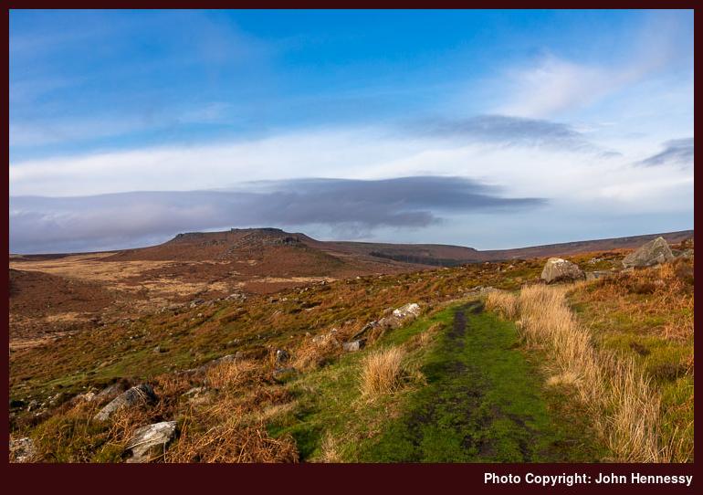
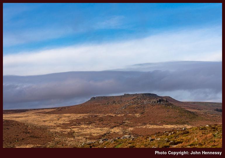
Crossing the road got me onto the Sheffield Country Walk, with views of surrounding moors catching some of the available sunlight. Higger Tor was among these, and there was an antiquity too in the form of Carl Mark Fort. The idea of continuing north might have appealed by for my designs on reaching Sheffield in more daylight than my previous amble in that direction. Even now, it tickles my sensibilities to think of passing Burbage Rocks and to reach Stanage Edge, closing the chain as it were.
On the day, I picked up a path leading to Houndkirk Road. On reaching the intended byway open to all traffic, I was trading solitude for the bustle of multi-modal usage. Dealing with other walkers along with cyclists and runners is one thing, but I was somewhat aggrieved by the sight of off-roaders engaged in green landing. That caused some clutter as I made for Ringinglow.
All such annoyances were left behind me, though; it helps when there are some quiet stretches that soothe your spirit. From Ringinglow, I made as if to head directly towards the outskirts of Sheffield, only to leave the road for a public footpath dropping me onto Clough Lane. This was my return to the banks of Porter Brook, albeit omitting Porter Clough this time around.
While I do not seem to have the photos to prove it, daylight was to persist all the way to Endcliffe Park for me at the second time of asking. There was some ice underfoot too, but this was no intrusion on progress. Neither did it prematurely force me onto city streets, so a little more closure was my lot before I mustered my wearying limbs for a meandering course to Sheffield’s principal train station.
The general run of weather may explain the dearth of photos accompanying this piece. It so happened that the hike returned me to Sheffield for the second time in two days. The second encounter was drier than a preceding shopping excursion beset by rain. Rain was also to await my return to Macclesfield after the walk, proving a point about what I had snatched during an otherwise unsettled run of weather.
Getting better photos remains a motivating factor that adds an idea for a visit to Sheffield’s more natural surroundings when an opportunity allows. It is as if you never can say that you are done with anywhere. The same could be said for a Grindleford to Hathersage station to station hike. Some places just cannot but offer more and more ideas for walking trips.
Travel Arrangements
Outbound train journey from Macclesfield to Grindleford with a change at Manchester Piccadilly. Return train journey from Sheffield to Macclesfield, changing either at Stockport (faster train) or Manchester Piccadilly (slower one); the journey is lost to my recollection now, but my sense is that I would have gone via Stockport for sake of speed and convenience.
From Hathersage to Sheffield with clag abounding but not obstructing
26th December 2022In many ways, this hike follows on from the last one that I did in 2017. It was the first of a pair of moorland rambles that finished in Sheffield city centre in darkness. The second one started from Grindleford to make the most of the shorter hours of December daylight, while this one began from Hathersage to fulfil a possibility that was spotted on that 2017 outing and followed part of the Sheffield Country Walk next to some appealing crags.


The way out from Hathersage shadowed the end of the previous hike. Because of declining light, that had made use of Coggers Lane after Denis Knoll for the sake of easier navigation; my memories of this are that it was quiet because motorised traffic went elsewhere from the car park at Denis Knoll. The views were available to a point at the start, but I entered Hathersage in darkness. This time around, I followed the off-road Baulk Lane on a course that took me to Green’s House via Brookfield Manor and Brontë Cottage.

My passing Green’s House was reminiscent of a walk that I undertook more than fifteen years before. Then, I was also bound for Stanage Edge, but I believe that I went north that day and returned to Bamford via Ladybower Reservoir. The walk may even have begun from Bamford, though the mists of time somewhat fog up certainty on that matter. There was even a photo in the online gallery of this website for a time that recalled this, and the approach was from the west back then.


This time around, I came to green’s House from the south and continued past it to the north, and not the west like the previous time. All the while, sunshine was coming and going, as it had been all day. There was a hazy feel to long-distance views too, with things looking a little claggy from time to time. There also was a piercing east wind, so that also ensured that I kept moving.


After Denis Knoll, I was retracing some of the steps that I traipsed the year before. The light was stronger because of the earlier time of day, and the views beckoned me forth. Buck Stone was passed, with Stanage Edge coming ever closer. As I approached, I surveyed the views that lay about me.


My lure was Long Causeway, a clear track that led through the crags of Stanage Edge. Tracks like this always appeal to me, so long as there is not too much multi-modal usage. This time around, that was not the case, so I could enjoy what surrounded much like I do on such things in Scotland.

The track took me past Stanedge Pole before dropping down to Redmires Reservoirs. The day was advancing, and I needed to be determined if I were to get to Sheffield. There would have been a time when I might have reconsidered my plans, but there was always the fallback of using a head torch later if needed. There was quite a way to go yet.


To get to Fullwood Lane, I made use of concessionary paths that were more boggy than that on which I had been travelling. There was some added route finding too as I veered around by White Stones. Nevertheless, I returned to tarmac and set to finding the path leading down to Porter Brook. Now, my course to the heart of Sheffield was largely set.
Light was declining noticeably by then, though, and that took away a little from the enjoyment that I might otherwise have gained. The banks of the watercourse felt wilder than I might have expected. The other surprise was how many were making use of the amenity that late in the day. It was not just stragglers like myself who were pottering about in the dusk. The attraction of more natural surroundings must defy any lack of light for them.
The trail does finish up in Endcliffe Park, and the increasing darkness caused me to bail out around Hanging Water. The rest of the way had me shadowing Porter Brook under street lights with by now tiring limbs. Beyond Endcliffe Park, it was a matter of making for the city’s train station. This was not as easy as walking along the banks of a stream, since improvements for motorised traffic add deflections to any sense of a direct course.
It had been a Sunday filled up with a station to station walk and many delights. If I had been more motivated or less occupied by other matters, I might have got out on Saturday instead. That might have meant an earlier start (trains start later from Macclesfield on Sundays) and hence better lighting on the Sheffield section of the amble. Instead, I was pondering another way to do just that. What was filling my mind was the prospect of another station to station walk: Grindleford to Sheffield. With shorter days, that shorter course might mean that I would not have needed to wait too much longer. In the event, it did not, and that is the next trip report that needs doing.
Travel Arrangements
Outbound train journey from Macclesfield to Hathersage with a change at Manchester Piccadilly. Return train journey from Sheffield to Macclesfield, changing either at Stockport (faster train) or Manchester Piccadilly (slower one); the journey is lost to my recollection now, but my sense is that I would have gone via Stockport for sake of speed and convenience.
An Irish Year
25th December 2022Changes that I am making to matters in Ireland were the cause of my spending a lot of time there this past year. That also meant that I really got to see more of the place than ever before. That was just as well for two reasons. One is that my explorations of Irish hill country have been more limited than I fancied. The other is that the pandemic had grounded me for 2020 and 2021. Being over there a lot allowed me to get more courageous again. There is further to go, but this start was useful compared to where I was earlier in the year.
The nerves applied during various trots starting and ending in Marsden during the spring, so some movement was needed. A day trip to Dublin got me started on flying again. After that, there was a hotel stay in Limerick that allowed me to sample the delights of Adare, the Limerick Greenway, the Lough Derg Way, the Slieve Felim Mountains, Killarney and around Lough Derg. Much of this was in unexpected sunshine, and some was inspired by what I saw from my hotel room as well.
A getaway from jubilee celebrations returned my Ireland. This time, my base was Tralee and I got some wet weather as well. Even so, any sunny interludes got used when other matters allowed. A hike along the Dingle Way from Tralee to Camp was one such beneficiary, as was a circular walk featuring Dingle and Ventry. An amble along part of the North Kerry Way also saw dry weather before something inclement arrived in for the evening time. That affected a second trip to Killarney as much as the presence of a bikers’ festival in the town. The weather also affected a hike from Dingle to Anascaul that might have seen me wander up to the Conor Pass if there were better views up there.
The Lake District got some attention for the first time in some years as well. One trip featured both Lingmoor Fell and Loughrigg Fell on a walk that attended to a photographic need as much as using up an idea that had lain in my mind for a few years. That was followed by a reprise of the Fairfield horseshoe, along with an ascent of Helvellyn. All of these enjoyed warm sunshine that allowed many photos to be made.
The same could be said for the major holiday trip of the year, for that took me to Ireland again. Killarney and Cork were the bases for this one. The former allowed me to frequent parts that I had not surveyed for nearly thirty years. There was one all-day stroll that took me around Knockreer Park, Ross Island and Muckross Lake. This was followed by a hike from Kenmare to Killarney that used past of the Kerry Way, with a diversion to the top of Torc Mountain. The Kerry Way also had a part to play in a serendipitous walk that took in the Gap of Dunloe, the Black Valley and the Upper Lake. These were followed by trips to Bantry, Whiddy Island, the Knockmealdown Mountains, Kinsale and Cobh as the weather continued to warm.
There was a return to Scotland too, though luck with the weather was such that a return trip is in mind. Staying in Stirling again would allow the Ochil Hills and Ben Ledi to be revisited. That awaits longer hours of daylight and a favourable weather window. The two trips that I have had already whetted my appetite for a part of Scotland that I either overlooked or surveyed twenty years before.
There was one trip to the Welsh hills too. This took me to the Ogwen Valley for a dramatic day that saw me go over Glyder Fach and Glyder Fawr. Eroded slopes were the cause of some adverse comment, but this was a warm, sunny day that offered much. Any plans for descending to Pen y Pass and Llanberis were rejected for time and transportation reasons. Assessing one’s progress often needs a change of route, not that it mattered in this case.
The last Irish trip did not allow more hill wanderings. Time was short, the weather was unfavourable, and other matters needed attention anyway. It was not as if a lot of satisfaction had been given, so I was not put off by this. The temptation might have been unwanted anyway.
The rest of the year saw me grow increasing tired, mostly because of lack of progress with the things that I need to get done. They are spilling into 2023, but that is another year. It remains to be seen how that will go, but trips to Galway and Clare as well as other parts of Europe and North America entice. Only time will tell how things proceed.
Shoreline stravaiging in East Lothian
24th December 2022Aside from getting windows upgraded in a house in Ireland and an announcement of future disruptive tax changes, the autumn of 2018 was steadier for me. It was a big difference from that of 2017 when emotional decompression was in order, or in 2016 when I had a big task in progress in Ireland. With less weighing on me, I was able to get out more whenever the weather offered.

One such occasion happened during a weekend stay in Edinburgh. That allowed me to walk from North Berwick to Seton Sands, surveying the East Lothian coastline as I did so. This had been inspired by an issue of The Great Outdoors magazine that I had read shortly beforehand.


There may have been a plan to follow the John Muir Way, but I was lured onto the beach at North Berwick, so I attempted to do most of my walking in the intertidal zone with exceptions when it did not work out. Views of offshore islands like Lamb, Craigleith and the more distant Bass Rock all held my attention as I continued on sand and over rocky outcrops.


It took time for views to change, although the ground underfoot was ever varied. Eventually, the islands that had been near where I started began to grow ever more distant. Others were out strolling too, but there was ample space for all of us. The tide was well out, and I even spied some kitesurfing going on in the shallow waters near the island of Fidra. After that, my lot included crossing of dunes and rocky outcrops to get to Gullane Bay. My course was changing from westerly to southerly as I went.


Eventually, I needed to go inland a smidgen around Gullane Point to reach Gullane Sands and Aberlady Bay. The prospect of a rising tide began to occupy my thoughts as I made my way across a broad expanse of sand. Behind me, I could see North Berwick Law catching some sun. My way to Gosford Sands was blocked by the depth of Peffer Burn, so I had no option except to turn inland to Aberlady. Momentary concern about tides cause me to cross the burn and get my trousers well wet in the process. A calmer mind would have ensured a retreat to a bridge instead of that more drastic action.

Sunshine had been terminated by a cloud-filled sky by this stage, but views of Edinburgh’s hills were not obstructed. Following the route of the John Muir Way conveyed me from Aberlady to Seton Sands, where a waiting bus convinced me not to walk any further. Nearby Gosford Sands or the beach of Seton Sands itself did not tempt me. Wet attire, though drying, was one dampener, but another came in the form of a little rain for a time. As it happens, I do not remember Gosford Sands not having that much extent at the time, in any case. What was also comforting was the quietness of the trail as light began to decline, since I was feeling more than a little foolish after my dunking.
While there might have been the prospect of following the John Muir Way for most of the way back to my hotel, it probably was best to curtail those ambitions for another time. Another trip to Edinburgh could use such a scheme, and there also is the possibility of including Dunbar in a hike. Neither idea has been used yet, but one hike easily inspires more, as I have found over the years. My wander along the East Lothian coastline had brought many delights and I even hear the sea as I look at the photos too.
Travel Arrangements
A return train journey got me from Macclesfield to Edinburgh and back. A single train journey got me from Edinburgh to North Berwick for the start of the walk, while Lothian bus services returned me to my lodgings from Seton Sands.