Category: Outdoor Skills
In need of some tidal awareness
Recent Irish rambles have brought home to me an important lesson to which I hardly devoted much attention before. It may be because I have spent much of my life inland and that I am attracted to a variety of hill country. The subject pertains to tides.
It is true that I made my over and back from the tidal Cramond Island near Edinburgh without incident. That perhaps was because the tide tables were posted on signs nearby. Then, I could assess if such a crossing was feasible so as now to get marooned. That is one of the few, if not the only tidal island that I recall visiting.
Otherwise, risk averseness has its part to play. Worms Head near Rhossili on the Gower in Wales comes to mind. The sight of others did little to encourage me out there. Knowing that I was without important knowledge was enough to stop me needing the services of the Coastguard. No rescue is needed when the risk is not taken.
The same applied to a visit to Galway where I did make my way out and back from Illaunafamona, near Salthill, without getting stranded on there. However, the encroaching tide forced me to go through a caravan park to get back on the return route to Galway to catch a coach back to Cork. Leaving later would have been better but for having made an advance booking; the evening was brightening, so it would have been worthwhile. Still, I got to the Coach Station with minutes to spare. My trespassing nearly cost me that too, and landowners may not have been impressed with a stranding on an island that they owned if it were to happen. The caravan park owners did not intercept me either, yet it is not something that I plan to repeat.
A stroll around Crosshaven was nowhere as dramatic. However, the tide was in, which meant that the absence of a cliff path sent me on a circuit that I had not planned. Given the other delights that were encountered, I do not feel short-changed. There had been a walk along the Greenway from Carrigaline in good autumn sunshine, and all else was favourable until I had to alter my route. In fact, I had the sun at my back, a favourable position for photographic exploits.
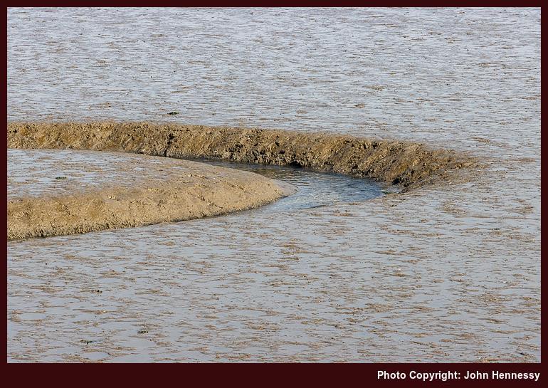
My having acquired a new base in Cork means that I now am nearer the coast than I ever have been and for longer too. That means that I get to notice the coming and going of the tides more than I ever have. A walking route that goes along the shore of Lough Mahon assures that. The mudflats that low tide exposes attracts its share of bird life too, so a set of binoculars has its uses here.
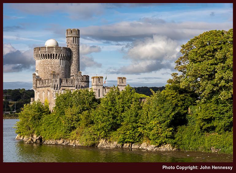
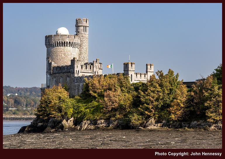
The subject of tides also cropped up on a circuit of Cork Harbour's Great Island that started and ended in Cobh. A narrow road along the north side of the island was seeing some encroachment through the very drainage culverts that ought to drain it. There were no such issues around Marloag Point and any other place that I passed, yet I did not delay. The hour of day ensured that as much as the chances of getting wet feet.
The cumulative effect of these encounters with sections of coastline is that I need to add checks of tide times to weather, transport and other things. Recalling the speed of tides on the island of Jersey accentuates this. It is little wonder that the U.K.'s Met Office includes this kind of information with its coastal location forecasts. It builds out the picture, especially when seas are roughened by gales.
Some experiences of Irish hiking maps
Much of my hiking has been in England, Scotland and Wales, where I have been rather spoiled by the quality of Ordnance Survey mapping. Things are quite different in Ireland, though the mapping offered here is nowhere as difficult to use as in other places where I have been.
The Standard Option
My go-to scale in OS mapping is 1:25000, while 1:50000 is the most common one offered by Tailte Éireann (formerly Ordnance Survey Ireland or OSi). That makes a difference when estimating distances on a ready reckoning basis. The smaller scale makes it easier to underestimate the length of a trail, and hence the amount of time that it will take to complete. With a need to make a bus back from a day hike, that can be a challenge, but one that is eased by doing things more rigorously in advance. Adding extra slack on the day will help too.

Another habit into which I have fallen is to look at a map to see what trails are available. This again is something that Tailte Éireann could improve. One absence is the lack of Greenway depiction; often, you get the disused railway line, which is a hint, but marking the recreational trail would be even better. While someone has put together a web app to show where Greenways are, having something more official would be better and may have more staying power than a volunteer effort.
It may have something to do with publishing schedules, but not all looped walks may get marked. That is what I founded with the Fastnet Trails around Schull and Ballydehob. At least, there is a website for those. Even so, having more of them marked on a map would help even more. Nevertheless, some are marked already, so some credit is due.
The same could not be said so emphatically for the trails around Mount Melleray Abbey near Cappoquin and Lismore in County Waterford. That might have helped me avoid some rough cross-country travel on a day hike around there that ruined a hiking trousers on me. Saint Declan's Way is completely absent too, so I ended up loading a GPX track onto Outdooractive for future reference. Since this goes from Ardmore to Cashel and through the Knockmealdown Mountains, it could offer hiking possibilities for another time.
Alternative Options
Following the aforementioned escapade, curiosity had me explore what is offered by EastWest mapping these days. They still cover the Wicklow and Dublin Mountains like they always have, and Wild Nephin is another area that they have covered for many years, but other ones are included now.
Parts of Munster now benefit, and the range includes the Knockmealdown Mountains, the Galtee Mountains and the Comeragh Mountains, not always ones that you hear much about when it comes to Irish hillwalking. The county of Cork is absent thus far, while the mountains of Kerry around Killarney and Dingle gain deserved coverage. In Connemara, there is a guide to the Western Way between Oughterard and Westport, along with maps of Connemara, Mweelrea and Croagh Patrick, and Achill and Corraun with Clare Island.
While I do have a Wicklow Mountains map in my collection, I have added one for Knockmealdown Mountains. Like many others in the range, it has a scale of 1:25000, which is more like what I find in Great Britain (Northern Irish mapping is much like what you find in the Republic). Those missing trails from the Tailte Éireann maps are noted too. Should a return to those parts come to pass, the new map will have its uses.
All in all, EastWest is on its way to becoming Ireland's answer to Harvey Maps in Scotland. That operation does not abandon Ireland, either. In fact, it offers two more than it once did: Dingle Peninsula and the Mourne Mountains. They complement longstanding coverage of the Wicklow Mountains, MacGillycuddy's Reeks and Connemara. Most are 1:30000, with the Mourne Mountains getting 1:25000 coverage.
What About Digital?
Much of the discussion here would apply to paper maps, yet I often use the Outdooractive app these days. That is equipped with maps from both Tailte Éireann and Harvey Maps. If I were to do the same for EastWest Mapping, I would need the Hiiker app. Since I plan to stick with what I have for now, I will leave the addition of another app until later. Even so, mixing information from different sources only helps when plying the trails, boreens, and ancient paths that criss-cross the Emerald Isle. Having a paper map and compass to complement digital tooling remains essential too. My Irish explorations may be facing a hiatus for numerous reasons, yet there is so much more to explore.
Recent changes in mapping technology
There have been a few things that I have been meaning to write about in recent times but I never got around to doing that because of other distractions. Anyone who has been here before should know that I have a fascination with maps and the advance of technology has done nothing to change that. If anything, it has meant that two interests of mine come together: computing and hillwalking.
As part of going lighter weight, using the OS Maps app on my phone has become a common occurrence and I still bring paper maps with me on longer hikes even if I use phones with long battery life. The old skills remain invaluable when technology fails because of a lack of signal or electrical power.
The OS Maps subscription also means that you gain access to extra content on the associated web portal and that got a recent refresh. One advance is that it can be made full screen but a hardware driver issue meant that it would not work on one of my PC's until I sorted the software problem.
Aside from the OS Maps app, I also have made much use of the ViewRanger app, especially on overseas trips. Ones to Ireland and Canada come to mind but the mix of content from existing providers with freely available mapping data proved to be a very useful one. That I managed to acquire enduring licences for some of these instead of subscriptions was an added attraction. It certainly made the option better in my eyes than what Geolives was offering through SityTrail even if subscriptions are how things are moving nowadays.
However, ViewRanger became part of Outdooractive so things changed. Because the pandemic kept me in the UK, I have not looked into the new operation so much but it could be something that I need to check for overseas escapades now that restrictions are easing again after the arrival of the Omicron strain of COVID-19 near the end of last year. Others have commented that the changeover has not been smooth but the free maps look comprehensive and I appear to have been able to carry over access to mapping data that I already had.
Speaking of travelling overseas, I am now a subscriber to Backpacker magazine and so have access to content from the Outside network. One part of that is GAIA GPS and the things are with hiking maps in the U.S.A. means that this is an interesting offering, especially if I get access through my existing subscription. When I tried before, I was able to see maps through its online portal but it would take an actual visit to really check out what is on offer. Though I am cautious, that might be more realisable than it has been for a long time.
Into nighttime
Over the last few months, I have gone walking in hours of darkness by design rather than accidentally as often has been the case. Much of this has been in urban areas in the name of remaining active after a day of working from home, but some have taken me away from hard surfaces as well. It all helps with getting through these more uncertain times.
The first time that I ever tried this was during a much-needed career break at the end of 2017. Then, I chose a nearby route that I knew well, and I relished the quietude once I had over some initial nervousness. The same route was plied by night several times during the winter of 2020/21 and the reduction in the chances of encountering others was as much an attraction as being out on moonlit ones and ones that were not so bright. Naturally, a head torch was put to good use in the process.
The same sense of peace and solitude drew me out again, and other routes were chosen. Most were near at hand and with better starting points as well. Each time, I was reminded of the reduction in the amount of information from what we have by day, and I was always on familiar ground. It was not just one's whereabouts that demonstrated this, but the placement of one's feet and one's sense of balance, especially when crossing a steep slope with a significant drop should one fall.
This traipsing reached its zenith on New Year's Eve at the end of a long day out that added an extreme elbow to two places that are not that far apart. Mostly, I try to keep away from where people live because having unexpected lights around a home in the countryside could feel unsettling and intrusive. Nevertheless, the countryside feels very different at night and being out there feels more adventurous than it might during the hours of daylight.
Alterations
Those of you who are regulars may note a certain change in the colours around here. Another bit of electronic fiddling was the cause of bringing the background colour to my notice. The new year has yet to see a proper piece of outdoors action. That's not to say that I didn't inspect the recent snow, especially given how much of it was plastered on the hills between Macclesfield and Buxton. That viewing took place on the second Saturday of the year from the confines of a warm bus rather than in an attempt to flounder through fields hosting feet of snow. Hearing and seeing how much was up there, thoughts were attuned to the need for snow shoes in such circumstances. It's little wonder that folk took to skis and going downhill on unexpected slopes like those of Kerridge Hill near Bollington. Drifting snow was starting to impede traffic while I was on my little excursion and it later closed the A537 Cat and Fiddle road almost completely. Buxton looked very pretty in its white coat on a bright day, but things were duller by the time that I reached Bakewell. It all made for an enjoyable spot of reconnaissance but a fuller bout of hill wandering is in order now that things are calming down, though there is more snow on the horizon for the middle of the week. It would appear that 2010 is getting an interesting start.
