Category: England
A year with much city hopping around Ireland, Switzerland and elsewhere
While you can plan as much as you like, a year never turns out quite as you hope. For me, that has been the story of 2025. A hoped for trip to Canada could not happen, necessitating a booking cancellation. The need to get more freelance work in a tough market simply weighed on everything else. Having addressed that need, it is only now that I can begin to look ahead again, even though a busy work life takes from that a bit.
This also got in the way of wilderness wandering, which meant my getaways involved cities most of the time, even if adjacent countryside also saw my footfall there. Also, booking a place to stay forces you to get going more than dangling the prospect of a day trip before you in circumstances like what I have experienced this year. That more likely made my excursions urban than they otherwise might have been.
Cork Residencies
January began in Cork, Ireland’s second city because of my spending Christmas there in somewhere that I have as an Irish base. My search for freelance work had begun without my realising the arduous road ahead of me. Otherwise, it was time to haul myself outside around such places as Blarney and Kinsale when a certain torpor could prevail otherwise. Before I left for the UK in the middle of January, a property matter was set in place that would close later in the year.
April would see me return, first for a weekend visit, searching for items that I needed to send to someone else and recovering after another discussion about new work came to nothing. The recovery was helpful, while the search remained fruitless in the interval before I returned for an Easter residency that allowed me to visit Cobh and Kinsale again, among other things. Then, my time was spent away from other city landmarks like its English Market, the north side’s Shandon area, University College Cork, Mardyke or Fitzgerald’s Park. Other things were on my mind.
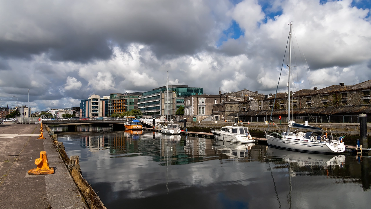
A funeral was the cause of my returning at the end of July. Apart from saying goodbye to an elderly relative, things were otherwise upbeat thanks to my commencing a new contract and getting out in the sunshine for some pleasant walks around by Blackrock Castle and Cobh on consecutive evenings; this is an area that is much influenced by its harbour and estuary. However, it felt too short a rendezvous, ensuring that a return is in mind as soon as a space comes up for such a venture.
Swiss Getaways
May brought a near miss with getting work organised and that left me feeling morose. Having felt on the fringes for too long, a conference trip to Geneva came not before time, even if it may have scuppered that earlier opportunity. These just in time searches are very fragile things, as I was to discover in June, albeit without any real consequences that time aide from feeling saddened at having to choose something else.
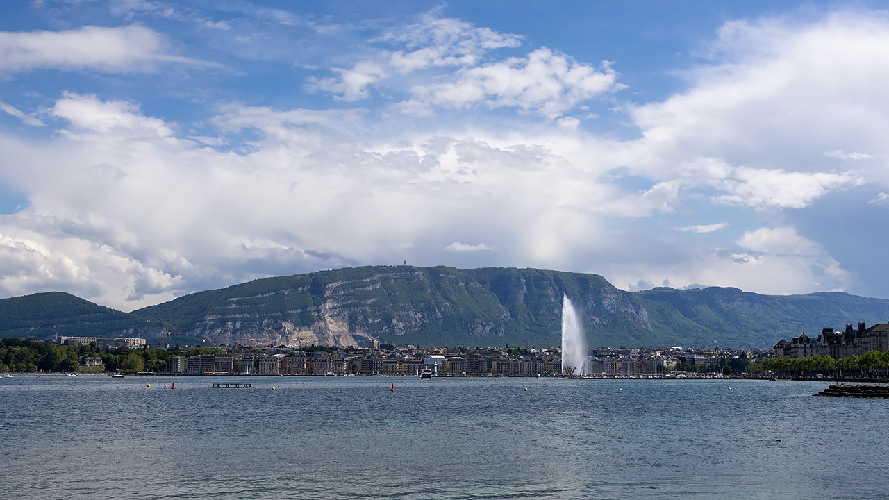
Sunlit evenings in Geneva ensured that I became sated with what the city offered, along with some complementary weekend sampling along Via Jacobi from Coppet back to Geneva. Landmarks familiar from a stay in September 2015 like Jet d’Eau, the banks of the Rhône and Lake Geneva were again frequented, while the cobbled streets of the old town climb to the Cathédrale St-Pierre offered new perspectives. Later that week, a certain amount of repetition aroused a need for novelty that propelled me to Bern for a glorious evening of strolling that did me a lot of good as I traipsed its loop of the River Aare, another first since September 2015.
Other prospects like Zurich and Lucerne appealed during my time in Geneva, until I saw the travel times were longer than I fancied. They offered a platform for a bank holiday getaway before which things began to look up for me a little. Lucerne was where I spent the better day of the trip, leaving Zurich to be explored in mixed weather. That limited photographic activity, yet it did not stop me embarking on a return sailing on Zurichsee that got me as far as Rapperswil, where I spent a good deal of time strolling around there and Pfäffikon under seemingly improving skies.
Since Zurich left an itch to scratch, a return ensued as May ended and June began. Hot sunshine was the enduring weather challenge this time around, even if it did little to stop me strolling along the shores of Zurichsee after following the banks of the Limmat or even along the banks of the River Rhine in Basel with that striking proximity to France and Germany.
Additional evening ambling around Zurich after returning from the latter led me into that city's nearby woods. There, I found an abundance of quietude that was healing, a refuge from the pervading uncertainty in my life. It was much needed and would have reached deeper into my psyche if my work life had been going better. It was quite a counterpoint to all activity around each city's Münster.
Passage through Paris was an element in all this journeying too, albeit far more briefly than during my travels in 2024. The first time was as part of a train journey conveying me all the way from Geneva to Macclesfield, while the second would have been the Zurich equivalent except for its expense. Then, it was Paris Charles de Gaul airport that was my exit point from continental Europe, a much quicker journey, albeit not one that was without its occasions for relaxation either.
British Trials, Solace and Celebration
While the Irish and Swiss segments of this piece have a certain chronology to them, even with Irish trips bookending the Swiss ones, the British portion does a spot of time hopping around each of them. First, there was the January return to the UK, after which I attended to numerous other matters that lay outstanding, possibly affecting my search for new freelancing work.
When meetings with a potential client came to nothing, I decided to break things up with weekend trips to Edinburgh and London. These mixed up revisiting old haunts with seeing new places while I rebooted my search for work. It was going to be out in the sunshine rather than being downbeat at home. My work strategy was getting a shake up too, which set the scene for coming months. Success would take time to come, meaning that there would be another trip to London early in June to attend a conference before everything came together.
Yet Another Scottish Incursion
When it did, there was cause to celebrate, albeit quietly. Before commencing a new contract, I headed north to Inverness, ticking off one last item from my excursion list for my time between contracts. It was in my head for the autumn of 2024 and might have happened if I could lure myself away from Ireland for longer during that September.
The ideas were rural in the main: Fionn Bheinn near Achnacarry, the Great Glen Way between Drumnadrochit and Inverness and the South Loch Ness Trail from Foyers or Dores back to Inverness. In the end, I opted for the first two, partly because of having better public transport options.
Even so, there was an evening spent in the highland city itself, pottering around the Ness Islands and passing Inverness Castle. On the trail back from Drumnadrochit, I briefly encountered the Caledonian Canal, though I did not spend as much time along its towpaths as on a previous visit as 2023 transitioned into 2024.
Eastern Quests
Norfolk, Suffolk and Cambridgeshire drew me away from home in July at a time when going east meant gaining cooler weather. This again was a mix of urban and rural, with much traipsing by the orienting River Wensum as well as a visit to Whitlingham Country Park. The medieval sights were surveyed too, especially around its cathedral close and its quiet green space within the city. There was time to traipse between Brandon and Thetford, shadowing the Little Ouse and passing through The Brecks under ever clouding skies. Those dented my brief visit to Ely and denied me photographic satisfaction there, ensuring a reprise two months later.
Though Ely was my target, I stayed in Cambridge because of its better accommodation options. A short train journey was all it took for me to see Ely's cathedral on a sunnier day, its unusual lantern tower drew a share of my attention before I pottered out of the city while skies broke over my head. Some rural ambling shadowing the Great Ouse showed me just how much of a landmark those cathedral towers make when viewed from the level, drained ground around the city. A return to its heart sated my photographic desires before another stroll by the river took me back to the train station under again clouding skies. Time had been called on my visit without causing any umbrage in my mind.
There was time to revisit Cambridge, too, to see and photograph different sights before I left for home. Advancing cloud cover again spurred me on to the train station after a sunny morning of ambling around the Backs, among other places. Different places were open compared with a previous encounter from years before. The River Cam was busy with punts and I left them to their way. Pembroke College saw me tarrying a while before I continued on a journey that was ending a sequence of summer jaunts, mainly urban but at times rural too.
A Southwestern Incursion
There was some time hopping above too: the two eastern excursions encapsulated a first trip to Devon and Cornwall. Again, cities pervaded with time spent around Exeter and Plymouth. Penzance became the Cornwall terminus for my rambling, allowing me to see the county's scenery from a passing train. While Exeter's cathedral and its surroundings clearly were a draw, they did not keep me away from the Riverside Valley Park, bounded both by the River Exe and the Exeter Canal. Exmouth was another location that lure, causing me to wander the coast a little too much for my own comfort given the advancing end of the hours of daylight. Nevertheless, this dalliance with the South West Coast Path did not result in ruin either, and Penzance became another, though my previous adventuring had tamed designs on an out and back trot to St. Michael's Mount. Thus, I made it home without any misstep.
Looking Ahead and Looking Back
There are upcoming business trips to Germany ahead of me, so the city hopping is not over for this year. Mainz is to be the location for a client meeting, with Frankfurt's airport proving essential for convenient travel. Because of the nature of the trip and the time of year, exploring will be at a premium, though. This also would be my first-ever overnight stay in Germany, only for the second likely to soon follow it: a conference trip to Hamburg. There, my time will be more my own, so more may come of it, though uncertainty pervades those possibilities.
A return to Cork for a longer spell is in my mind too, even if one cannot hope for too much when the hours of darkness are longer; an Easter stay would be better on that score. Beyond that, another conference could draw me to Italy for the first time. The venue is Milan in a time when hours of daylight are more amenable to personal city explorations. Since this is quite a time away yet, plans are not at all firm at this stage.
On reflection, there was a lot of temporal toing and froing in the above, unlike any rivers that flowed in only one direction. That was the sacrifice caused by focussing on locations to provide a thread holding together the whole account. Returning to the hydrological theme, it may have made the account tidal in places.
Another theme was what eventually became a successful search for freelance work, one whose busyness perhaps keeps me away from gallivanting as much the technological novelties that are coming my way. Reading is happening in parallel and something may stick there too, even if it feels far too premature to be considering summer holidaying plans. Last year's hubris does sit so well now.
Second chances and clearer skies: Revisiting Ely and Cambridge with a camera in hand
Last weekend, I forced a return to England's eastern reaches despite ongoing workload, political upheavals, hotel room assignment errors by distracted staff and personal blundering with technology (a new phone was presenting me with a learning curve). This time, it was the turn of Cambridgeshire, with a base in Cambridge itself following a Friday night arrival.
My real target was Ely, after my previous incursion into these parts left me seeing the place under skies laden with heavy cloud and dampness in the air. That was to occupy me on Saturday, though the state of the skies did not fill me with confidence regarding photographic prospects. Patience was to answer that, with breaks in the cloud cover to allow for pleasing photos to be made of the city's cathedral and its environs.
There also were chances to venture into some adjoining countryside courtesy of following short sections of the Hereward Way and the Fen Rivers Way. While I stuck with train travel, the latter would have taken me all the way back to Cambridge if I so desired; timing likely was restricted for that anyway. The small taste of fenland wandering was enough to sate me in any case, especially when I had photographic satisfaction in other ways.
On returning to Cambridge, I attended to a matter after sorting out hotel room confusion caused by my being booked into one room and given a key card for another. A quiet evening ensued beyond all this before I set to sauntering around Cambridge again the next morning. Next to ten years had passed since my last dalliance with the place, mainly on a Sunday after a Saturday arrival.
This time, I remained more central than I may have done on my previous visit, which may have taking in Midsummer Common before I serendipitously arrived into the grounds of St. John's College, where I spent a deal of my time back then. This time around, they were off limits without paying a £15 entrance fee. Not wanting to devote the time needed to get value from such an investment, I spent my time elsewhere, and the same applied to the Botanic Gardens later on my rambles. After all, there were ample other places for strolling, some of which were beside the River Cam and other watercourses.
Pembroke College became one of these places to tarry awhile, as much as the grounds of Trinity College in the Backs. It was while I was in the grounds of the former that clouds grew more obstructive of sunshine, giving me a hint that my time of departure might be near. Given that other parts of England were having it wetter than where I was, I could not feel shortchanged to any extent. After all, there had been much pleasing photography to savour, even if the whole venture had happened against the run of play in some respects.
Travel Arrangements
On Friday evening, after work, I travelled by train from Macclesfield to Cambridge, making connections at both Stoke-on-Trent and Nuneaton along the way. Next day, I took a return journey to Ely and back. For the homeward journey on Sunday, I caught the train from Cambridge back to Macclesfield, this time changing at Birmingham New Street rather than retracing my original route.
Hiking over Lingmoor Fell and along Loughrigg Terrace: A journey from Great Langdale to Rydal
In the summer of 2014, I left some unfinished business after another seed had been planted in my mind back in February 2009, when I hiked from Old Dungeon Ghyll Hotel back to Ambleside, and the experience sparked an idea that stayed with me. There was nothing to dispel what lay in my mind, not even a December 2016 trek from Great Langdale to Grasmere in stunningly crisp and sunlit if frigid circumstances.
It took until May 2022, as I began to shake off the constraints of the pandemic, for these inspirations to be merged into a fulfilling day hike. Thus, I finally realised a vision that had lingered for years: reaching the top of Lingmoor Fell and making new photos of Grasmere. This was a day trip in a time before I again began to stay away from home in the U.K., though a trip to Ireland had involved exactly that. My sequential arrivals in Windermere, Ambleside and Great Langdale offer occasion to potter about Ambleside while awaiting the bus to the last of these. Once I got there, my traipsing on foot could commence.
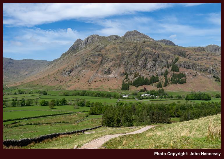
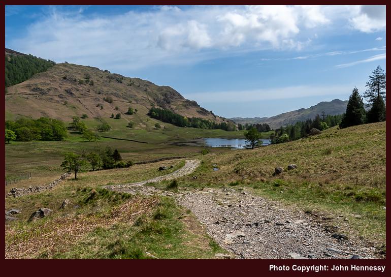
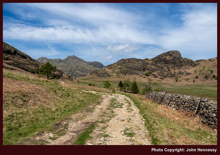
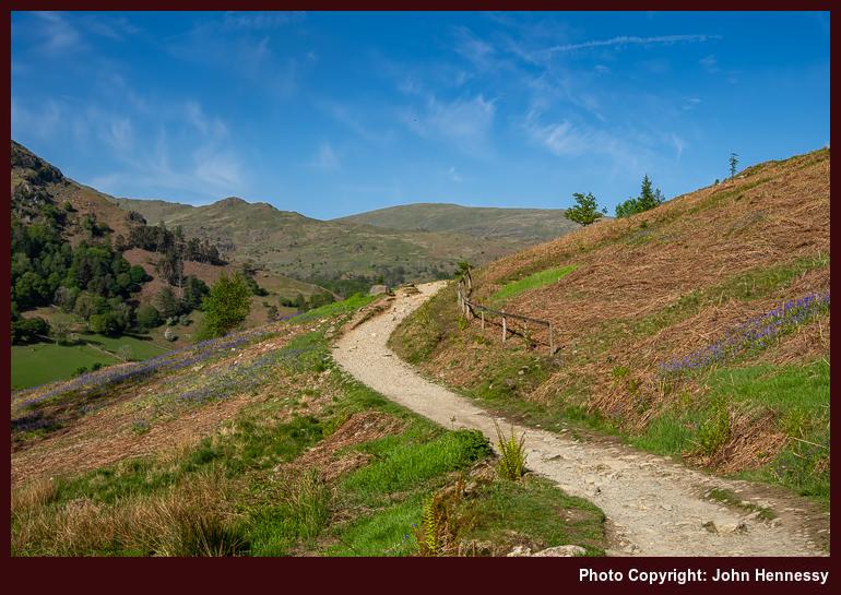
Once in Great Langdale, I began to make my way towards Blea Tarn, first along the lane leading to Little Langdale before peeling off onto public rights of way for the rest of the way. As I gained height in the heat of the day on the flank of Side Pike, views opened out below and around me. It was one thing to witness again the craggy eminences of the Langdale Pikes and quite another to peer along the line of the Mickleden Beck, one that I followed south under clouding skies at the end of May 2008. Seeing that under brighter skies was a definite bonus.

The way up from Great Langdale was unrelenting until I crossed the road to commence a trail below the slopes of Rakerigg. The easing of gradients beyond this point was welcome, though that meant losing those downward views that I had been enjoying before then. Nevertheless, there remained plenty to savour on the way to and around Blea Tarn. Some young people had music playing, something that was less easy to comprehend with the soundtrack that nature was offering. Maybe you have to live a little to grow to appreciate those natural sounds.

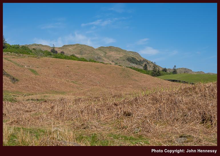
After crossing more level ground, a sterner test awaited: the ascent of Lingmoor Fell via a steep pathless flank. While going around by Bleatarn House to pick up an informal path following the line of a beck may have been wiser, I saved on distance by taking a more direct approach. Pausing to take in what lay around me was demanded by the gradient, as much as patience with my then under pressure legs. At least, the terrain had yet to be choked by bracken, making it easier to see where to place my feet. Fronds were slowly unfurling, though, a hint of what was to come.
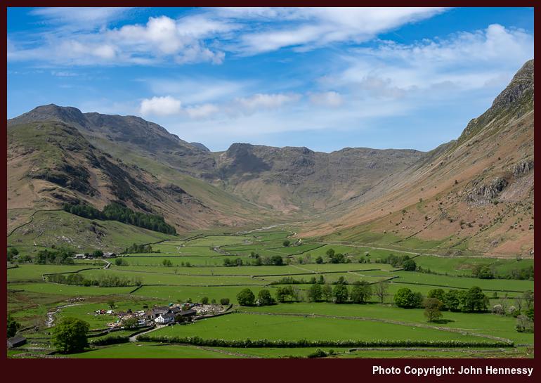
In time, the slopes relented near Brown How, the summit of Lingmoor Fell. Naturally, I had to visit that top to witness the splendour that lay around me. All the while, I had been on access land, ensuring that no charge of trespassing could be made against me for the way that I went. A useful wall acted as a handrail for continuing on my way until I finally began the descent to Dale End, with glimpses of Elter Water and Little Langdale Tarn.
From Dale End, I pressed on towards Elterwater village in the afternoon heat. Kinder gradients meant that reasonable progress could be made, and I felt the need to push on in any case. A diversion around by Elter Water (the lake) was not on the cards this time around. That may be an excuse for a return to sate a photographic need. Instead, I crossed the B5343 to commence a taxing ascent to High Close, entering into countryside last frequented in August 2014.
Then, I stayed in the YHA hostel around there on a day through grew increasingly dull until rain arrived while I was exploring the surroundings after arriving at my lodgings for the night. Even under overcast skies, everything looked appealing, and I hiked to Grasmere village the following morning. The whole escapade had an end of summer feel to it and pervaded the journey home afterwards.
This time around, it was a lake that drew me and not a village. The afternoon was reminding me of an even earlier incursion, on a Sunday when transport foibles frustrated a trip to Wales. Then (which could have been in 2004), I ventured forth on foot from Ambleside before crossing Loughrigg and making photos as I went. However, the film stock that I used made exposures appear too red for my liking, inspiring the August 2014 reprise. Nevertheless, there was much to savour that earlier afternoon, etching it into my memory even now.
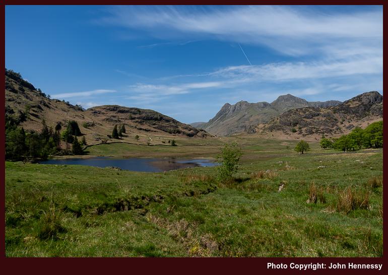
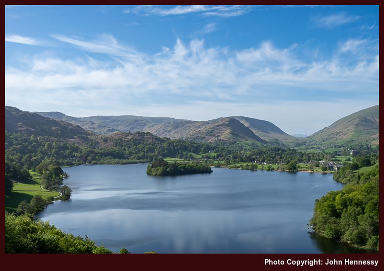
On leaving the lane during the 2022 ramble, I reached Loughrigg Terrace, the vantage point for the above photo. One thing that struck was that my timing might have been better because shadows were being thrown by the sun in places where having them lit might have given a better result. That brought challenges with composition that I may have overcome. After all, the outcome beats anything that I got before then.
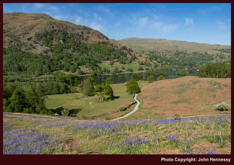
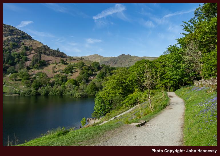
Unlike earlier sections of my walk, this one was busier. Others doubtless were drawn by the countryside and the weather, and their presence influenced my routing. Even with weary limbs, added uphill travel on a permissive path brought added quietude and more expansive views. As I continued on my way, I was reminded of that earlier Sunday afternoon. Then, whitethorn bushes and trees were in flower, while it became a moment for bluebells to hold my attention during the most recent encounter. All that lay around Rydal Water was catching the sunlight perhaps better than Grasmere, a happy accident of positioning.
My time around there ended with a wait at a bus stop for the next service to Windermere after getting to Pelter Bridge on a byway and subsequently walking back towards Rydal after that. Unlike a preceding occasion when a similar walk had continued to Ambleside, no such inclination arose this time. After all, rest was needed after all the exertions on what had been a satisfying day of rambling; it is days like these that draw you back time and again. In summary, the whole enterprise had drawn on previous encounters whilst also adding something distinctive to boot.
Travel Arrangements
For this outing, I took a round-trip train journey from Macclesfield to Windermere. From Windermere, I hopped on bus service 555 to reach Ambleside before bus service 516 took me the rest of the way to Great Langdale. Service 599 was used to get back from Rydal to Windermere at the end of my hike, allowing a chance to get some refreshments before I continued on my way home again.
Heading southwest
Last weekend, I ventured to parts of England that I had not visited before: Devon and Cornwall. My base was Exeter, and any strolling was mainly urban in nature. Nevertheless, I did head out of the city by the banks of the River Exe and the Exeter Canal as far as Riverside Valley Park before turning back again. While others were so minded, there was ample space to avoid any sense of being overcrowded.
One back within city limits, I headed to its cathedral district on a photographic errand before ambling back to my hotel around by the city's Victorian era catacombs and a former abbey. After attending to a matter, the evening sunshine sent me wandering again, this time as far as Exmouth, where I pottered around by a coastline with many enjoying the glorious weather. As the day proceed to a close, I continued as far as Orcombe Point.
Since a landscape photographer was stationed there with her tripod-mounted camera, I did not intrude and set off to make my way back within urban surroundings again. Using a permissive path on National Trust land became the cause of my going astray, not a brilliant with the sun having retreated beneath the horizon. This caused me to follow more of the South West Coast Path than was ideal at the time.
The sense of urgency with which I made my made through Devon Cliffs Holiday Park may have attracted the attention of security if overheard radio chatter at the park gate was any indication. One past that point, all was unhindered and without any untoward exchange of words. Fortuitously, a bus was seen to pass on its way into the park, so I waited for it to turn around so I could speed up my return to Exmouth train station, feeling more than a bit foolish on the way after my blundering.
That sheepishness had plenty of time to fade over the following day. It was mainly occupied by proceeding as far as Penzance on the first rail departure of the day. The three-hour journey time was new information to me, yet I was not deterred. Getting to Cornwall for the first time was enough of a motivation. While St. Michael's Mount was ever present in eastern coastal views, it was just too far to walk there and back due to the travel time back to Macclesfield.
After strolling around the place for more than an hour, I was ready to set off again. Fancying a brief stopover in Plymouth, an idea with which I toyed the previous afternoon, I left on an earlier train. If I had expected forty-five minutes to suffice for an out and back hike to Plymouth's shoreline, I was to be proven wrong. Though that delayed my departure from the city by an hour, it was more than worthwhile with what was there to be savoured. That I got a quieter carriage for the journey as far as Birmingham was an added bonus.
The tight connection in Birmingham was a concern to me, especially given a hold up on the approach to New Street Station. Nevertheless, all was well, and I made an earlier coach connection from Wilmslow to Macclesfield too. If I had left Penzance or Plymouth later than I did, I might have been far more concerned.
That dalliance with the tail end of the Jurassic Coast near Exmouth popped another idea into my head for a weekend getaway. However, reaching the Dorset coast appears too long for an after work getaway of a Friday evening. Travel connections in the area are not as convenient either, causing me to question the motivation for such a proposal. Thus, I am leaving this prospect aside, at least for now. Catching Ely of a sunny weekend is more practicable and realisable, so that could be next.
Travel Arrangements
Here is the itinerary for this journey: 1. Travel from Macclesfield to Wilmslow: Taking a rail replacement coach service. 2. Wilmslow to Exeter: Catch a train, changing at Birmingham New Street. 3. Exeter to Penzance: Continuing the journey on a direct train. 4. Penzance to Plymouth: Board the train to Plymouth. 5. Plymouth to Wilmslow: Head back with a train change at Birmingham New Street. 6. Final stretch from Wilmslow to Macclesfield: By rail replacement coach service.
Revisiting the Fairfield Horseshoe: A stirring trek through some of the Lake District’s craggy beauty
The overriding memory of July 2022 is that of the record-breaking temperatures endured during the middle of the month. In hindsight, it would have been more productive not to have tried working through this at all, telling my client as much at the time. Scarcely anything could be accomplished in these conditions.
Not having air conditioning in a terraced cottage in the north of England was no preparation for temperatures exceeding 30° C around the clock, which meant that nights largely were sleepless as a result. Having a place near the coast in Ireland might have made for a good holdout while this was happening, something that only came into my possession last year, two years too late for that episode.
Before all that meteorological fury, I scurried north to the Lake District for a day hike. The destination was inspired by reappraisal of photos in my online gallery, a pervasive trend throughout 2022. It had been the most of twenty years since I first completed the Fairfield; a reprise came not before time. Since film photography was my mainstay back then, this was an opportunity to engage in some digital capture of what is found around there while following a similar route.


The preceding night may not have been as restful as I might have liked, yet I got to Rydal at around 10:00. On that round all those years ago, there were fewer people around until I got as far as Fairfield. The reprise was busier, especially on the ascent of Nab Scar, where the steep slopes caused others to clump together on rest breaks. Even at that stage of the day, there was summer heat to be felt, so the ascent was sweaty work.


When the gradients relented, I found somewhere to stop for a while to take on board some refreshments and savouring views of Rydal Water, Loughrigg Fell, Grasmere and whatever else lay about me. Because it was likely that there was a bolus all staring at once that morning, I left others pass on their way. One joked that they were on their second way around when they passed me again after my overtaking them during the initial ascent. It might have been prompted by the pandemic strictures easing substantially, but there was a feeling of added camaraderie on this round.

Once I got going again, Heron Pike was my next landmark. With everyone now more scattered, each could have more space, and that also applied to me. The going was now gentler than before and greater views were opening around me. It never ceases to amaze me how stiff the first few hundred metres of an ascent can be, only for things to ease off once you are higher up; then everything can feel a little more plateau like. This can catch you at the end of a descent too, as I found on this hike, and glacial action often is the cause of such arduous going.


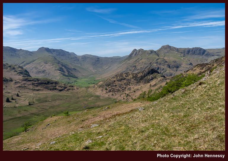
The summit of Grey Rigg was my next staging post as I navigated the undulations atop a narrowing ridgeline; gradients again stiffened on the final approach to the summit to open up more views for me. To my left lay the narrow valley leading up to Grisedale Hause and then Grisedale Tarn. It was a scene showing the latter that I had in my mind's eye for its capture using newer technology than I had all those years ago. The further up and the further in that I went, the more that I got to savour.


Even with reaching the top of Great Rigg, I was not done with uphill gradients just yet. The last heave on the way to the flat top of Fairfield needed to be surmounted first. Patience was in order at this point before things became much kinder. On the way, I could glimpse my return route as it threaded between Dove Crag, Hart Crag and other eminences. Once on the top, the high point of my day's walking, I could glimpse St. Sunday Crag and Helvellyn to the north. The former was the subject of a yomp around eight years before, and the end of August would see me surmount the latter. There was topological majesty in every direction anyone could face, all brightly lit on the day.


Once you reach the greatest height of your day, the only way is down, not that such a reality means that it gets easier from there. Initially, the inclines were kind enough, and I could peer into Patterdale and make out the outline of Place Fell, a summit I surmounted in January 2010 at the start of a year of career turbulence for me. The list of fell tops that I would cross became Hart Crag, Dove Crag, High Pike and Low Pike.
It was after the penultimate of these that gradients again stiffened, that being my lot until I reached the floor of Scandale at High Sweden Bridge. Walking poles were essential for saving some knee strain, and patient foot placement was my lot while allowing the fleeter of foot to pass me; everyone has to hike their own hike. For a time, it seemed easier to follow the informal path by the stone wall instead of seeking out the line of the public footpath.
That came to an end when a challenging down scramble lay before me. Then, I sought out the public right of way to High Sweden Bridge, leaving the topological drama of High Brock Crags and Low Brock Crags behind me. This also left a walking group to go their way, possibly towards Low Sweden Bridge, mine turning out to be a quieter affair; the rest of the descent to Ambleside was now at hand. This broad track better suited wearied limbs, allowing patient progress to convey me safely onto busier streets, where I sought out the main bus stop after a satisfying day.
In summary, I had experienced what I came to encounter, making many images and enjoying the round. Though I normally seek quietude, the moments of shared camaraderie added its own special moments too. Any challenge posed by the warmth of the day has faded from recollection now; it was a scenic grandeur that stood out for me. This was a reprise more than worth doing as it took me around places that I have frequented before. It was great to see them all again.
Travel Arrangements
A return train trip from Macclesfield got me to Windermere. From there, I had a choice of bus routes for getting to Rydal for the start of the hike. The same applied for getting from Ambleside to Windermere. You can use either service 555 or 599 for this; the latter goes between Bowness-on-Windermere and Grasmere, while the former goes between Lancaster and Keswick.