A spot of island hopping Part 3: exploring part of the Harris Walkway
15th September 2008Tuesday, August 12th:
It’s been a while since the last installation of my Hebridean trip report so it’s about time that this made its appearance. Picking which photos to include did cause some of the delay and I hope that I picked the best ones; there were many contenders of equal quality and it was hard to select one over another. The cause was that the Tuesday of the week of my visit was blessed with marvellous weather and the countryside looked well in the glorious sunshine.
Monday’s weather was something of a mixture without coming close to being a chore to bear. I did meet up with some rain, but there were spells of blue skies and sunshine to be had at times too. Yes, clouds abounded, yet there was no misery. Tuesday was to improve on this and I arose to the sight of clear blue skies and sunshine. Not knowing whether it would last caused me to take the camera on a short sortie before breakfast. I need not have worried because a glorious day was ahead of me. It might have clouded over later on, but the rain stayed away and I got in an excellent stroll.

After a good breakfast, I caught a bus to Àird a’ Mhulaidh (Ardvourlie in English) from where I was going to walk to Tarbert by way of the Harris Walkway or Frith-rathad na Hearadh. As it happened, I disembarked from the bus a bit further on than I had intended, but that was fortuitous: I spotted a promising opportunity for a walk on the day after. Though I was sorely tempted by the prospect of crossing through the hills to Miabhaig (anglicised to Meavaig), a certain reality made me stick to my planned course.
That reality was the fact that I was carrying everything for a week with me that day. For my other walks, I was able to lighten the load on my back, but this was the one day when that wasn’t possible. The result was that I was travelling perceptibly slower than I otherwise would, something that echoes a sentiment expressed by Andy Howell after his recent trek in the Pyrenees. Maybe I need to get in some training for walking with heavy but still sensible (15-20 kg) loads…
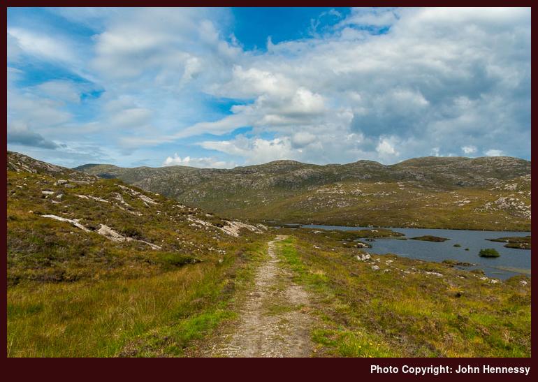
So, adapting a pace that was more akin to a tortoise than a hare, I made my way along the shores of Loch Shìphoirt (or Seaforth). The load on my back wasn’t the only thing that was slowing me down: the day couldn’t have been better and the scenery took on a most appealing aspect. Eilean Shìphoirt (Seaforth Island) looked far more lofty than its 217 metres summit would suggest. It was all in the steepness and that is very much a feature of Harris. The only fly in the ointment was that I was walking on tarmac and was to continue along the A859 until I got past the bridge over Abhainn Scaladail. Thankfully, the road wasn’t that busy at all and I was well away from it by the time that the traffic from the Uig ferry started to make its way north from Tarbert.
On my OS Explorer, the track that I was intending to follow was merely an undistinguished dotted line, one of many depicted on Scotland’s walking maps. It gave me no hint that this was the start point for the Harris Walkway that officially opened by Cameron McNeish in 2001. Of course, signs on the ground gave the game away. The track itself cut an obvious line as it went up the side of Caisteal Ard and Cleit Ard as it carried on my ascent from the bridge. It may have been the post road from Stornoway, was very much a green lane and was boggy over a lot of its length with a good deal of water underfoot at times. Given the summer that we got this year, that should be no surprise and surface water is a minor perturbation for a hill walker anyway.
Gaining height allowed me wider views and they continued to vary as I plied my way back to the A859 again. Sea lochs, steep-sided hills and freshwater lochans were all part of the fare on offer. Views of An Cliseam (the Clisham) abounded too as I took my time to enjoy my good fortune and took advantage of any benches that I found too. I didn’t know how long it would last, but there was no sign of dramatic change as I mounted saddle between Cleit Ard and Gormul Màraig.


On returning to the A859, the skies became cloudier, but the morning was good and there was sign of rain. I soon reached my final escape from the A859, until I reached Tarbert, that is. I lost height quickly on the minor road to Màraig (Maruig) and Reinigeadal (Rhenigadale). It was only in recent years that it was extended to the latter, which until then was only reachable on paths and tracks up. There is a Gatliff hostel at Reinigeadal which sounds a wonderful prospect once you strike up the trust to depend on finding a bed there without booking ahead. I suppose that’s easily achievable if you travel in the low season and it might not be too chancy in the summer either. Nevertheless, I’d rather have some sort of shelter with me just in case…
After losing all that height, I soon lost the tarmac at a switchback bend in the road to start on another off-road section of the Harris Walkway. It’s 6 km could be done much faster than the time that I took over it but I had a heavy load and there was some wonderful countryside to be savoured. Even with the pervasive clouds hiding the sun on me, it still looked glorious. You couldn’t miss the cloud-free top of An Cliseam even if it were one of many of its kind, all of them equally impressive in appearance. As I made the gradual ascent of Bràigh an Ruisg, some walkers got out of a car on the road that I had left to walk the very same track. As I took a break for some food and to enjoy the views, they passed me, the only other walkers that I’d seen all day. I was happy to let them go on ahead of me; the last you want in places as nice as this is to feel as if you are some kind of line of traffic, especially when there was no need for it.
Going up and over Bràigh an Ruisg was the cause of my losing one set of views for me to get others in their place. For a short while, the sun got free from its cloudy prison and a camera was set into action before I left An Cliseam after me. Once I got down from the bealach, the terrain was to be flatter as I bimbled by the lochans along the floor of Gleann Lacasdail, stopping at times to take in what was around me. Blue sky and sun still broke through, but cloud cover was increasing all the while.
It didn’t take too long before the Tarbert-Scalpay road started to come into view and the sight of a goodly number of cars and other vehicles going along it was not what I wanted to see. Nevertheless, by the time I overcame the final spot of ascent to reach this road near Urgha, things had quietened down for a none too taxing tramp to Tarbert. Walking on a hard surface like tarmac is rarely pleasant when carrying a heavy load, but having to remain alert for traffic adds to any discomfiture. I was therefore very thankful to have missed the earlier traffic.
Tarbert was reached in good time so I had the opportunity for a rest at my accommodation for the next two nights before pottering out for a restorative meal. After that, I took the chance to amble about the place where I was to spend two nights without the encumbrance of a heavy pack. That liberation from having to carry everything with me was to find use for my walk the next day too. However, that’ll be something for the next post in the series.
Familiar, yet not so familiar
9th September 2008English may pervade all the U.K. these days, but other languages live on too and the names of places and landscape features like hills betray the influence of those non-English languages and cultures during its history. Celtic, Anglo-Saxon and Norse names have remained in existence, even if they have morphed over the years. That of course, presents that challenge of pronouncing whatever a name might be and, even in England, that’s not always a straightforward matter. The usual rules do not always apply.
In Wales and Scotland, the linguistic rules of the likes of Scots Gaelic and Welsh might be very regular but you need to know them and it can be hard to discern and remember them all. Welsh is (in)famous for its additional consonants and vowel sounds, but the same comment applies very much to the Gaelic languages too. For some reason, I used to think that Irish was far more accessible to anglophones until it dawned on me what we do with vowel sounds. When you don’t know those rules, personal forenames like Aoife, Eoin, Eimear and so on become a minefield. My schooling has meant that pronouncing those names is second nature to me, so much so that I didn’t realise the traps until relatively recently.
Even I can get caught in linguistic tar pits too. The chasm that exists between Scots Gaelic and Irish is one that really comes to mind and, while visiting the Western Isles, I must admit to sticking with anglicised names like Ardvourlie and Ardhasaig in place of their Gaelic equivalents so as not to cause confusion. That isn’t to say that there aren’t similarities between the two languages; it’s just that there are enough differences to allow for woeful inaccuracy and imprecision at times from someone using his school Irish.
Take the forename Eoin, for instance. In Irish, it is pronounced like the Owen, the Welsh version apparently, while Scots pronounce it like Iain. Here’s a hill country example from Scotland: aonach. The Scots say “ann-och” while the same word in Irish is pronounced “aynock”. Not only are they spoken differently but their meanings differ too with the Scottish version meaning moor and the Irish one meaning fair or market. Gleann is yet another example of different pronunciations of the same word and with the same meaning in both languages: the Irish counterpart rhymes with clown while the Scots turn it into “glen”. It should be easy to see that the list of occasions where applying the rules of Irish to Gaelic would produce the wrong result could be a long one. It might be better to learn Gaelic without too much recourse to Irish to reduce the number of errors.
Even the English word Gaelic is uttered differently in the two countries. Scots say “gallik” after the word Gàidhlig while we in Ireland go for “gaylik” instead. Incidentally, the Irish word for the language is Gaeilge (spoken as “gyael-ge”). Both languages may have had a common ancestor but they have gone their separate ways since and I wouldn’t be surprised if Old Norse had its influence too.
Having a dictionary and following the rules that it describes would help, but there’s nothing quite like hearing a word spoken by a native speaker for fine-tuning things. Even so, I really should get out that Gaelic dictionary that I picked up in Tyndrum. It might even keep me out of trouble.

It’s my week wandering the Western Isles that has brought all of this to mind and their official title of Na hEileanan an Iar (try “na hell-a-nan an yar” if that’s new to you) should be dropping a hint as to why. Even cursory examination of OS mapping will reveal almost exclusive use of Gaelic place names and my trip reports will adopt the convention of using Gaelic names in the main with the English versions in brackets the first time that I refer to a place that has one. I won’t be distracting from the tales of my explorations with pronunciation guidance but you should be able to find anywhere that I mention on a map. Hopefully, that will make things a little easier to follow.
The Harris Walkway, an attractive hiking option
7th September 2008You would think that a trail passing through the countryside of Harris with its wondrous hills, glens and lochs would be well publicised. However, that does not appear to be the case for the Harris Walkway and I came across it while following tracks marked on my OS map during my explorations of Harris last month. Even finding a description of it on the web is not as easy as it should be. I did manage to locate an article written by Cameron McNeish for The Sunday Herald shortly after he officially opened the trail in 2001 when he was president of the Rambler’s Association in Scotland. Here’s an excerpt that gives you a good flavour of the route followed:
Start: A859 road just E of bridge over the Scaladale River. Grid Reference: NB186096.
Finish: A859 road near Seilebost. Grid Reference: NG090971.
Route: From the cairn by the side of the road follow the green track S past Caisteal Ard and Gormul Maaruig. The track rejoins the main road for a short distance before following a minor road to the bridge over the Abhainn Maruig. From here a track runs S over the Braigh an Ruisg and down to Urgha Beag from where it’s only a short distance to Tarbert. From there a combination of roads and paths run through Cadha, Diraclett, Kendibig, Meavag and Drinishader. From the head of Loch Plocrapool another track and minor road combination runs to Grosebay from where a green road runs over the hills behind Cluer and Stockinish. Follow the line of the Sgurran Ruadha dyke N until you meet the road again on the zigzags of the Uamh Ard. Follow the road down to the junction of the Stockinish road, turn right up the sign-posted track and follow it through the bealach to the A859 near Seilebost.
All in all, it’s a good twenty mile trek so splitting it over two days sounds eminently sensible. The trouble with trying something like this in one day is that you are rushing along and that Harris deserves much better than that. Leaving some time to take it all in is very much in the spirit of the island. Not having hoards following you or ahead of you like the West Highland Way in summer makes it easy to slow down and relax a little. From my experience, I reckon that the countryside through which you’ll be passing demands nothing else.
A spot of island hopping Part 2: crossing to Harris
5th September 2008Monday, August 11th:
Ferry travel and island hopping are often synonymous. During previous Scottish outings, I have been known to explore Mull, Iona and Arran with Caledonian Macbrayne (Calmac to one and all) getting me to and from the islands in question. An Easter excursion to Arran involved an overnight stay but Mull and Iona have only ever seen me on day trips. Kerrera has been the same with its little passenger ferry getting me there and away.
The main way onto Skye these days is by going over its well-known bridge, but there are ferry options for getting there too. One that I have used is that running between Armadale and Mallaig, and there is another going between Glenelg and Kylerhea. That is a small community-run affair but it is summer-only like the much larger Calmac ferry. Unlike others that I have frequented, Skye has seen me on multi-day trips a few times, although there have been shorter ones with me spending just a single night on the island too.
My Hebridean explorations last month had me spending just the one night on Skye with a few hours spent around Ben Tianavaig as well. I have shared that here already so I’ll move things along to that ferry ride to Harris. The sailing itself lasts an hour and forty minutes and the crossing of the Little Minch does take you sufficiently far away from land that they need registration cards for the crossing along with your ticket. That’s not to say that any sights on the crossing are devoid of land. Just stand on the right side of the boat and there’ll be plenty to see.
I made my way to the cafeteria at the start of the crossing so we were well out of Loch Snizort by the time that I returned to the deck. An Easter Monday return from Arran taught me that getting fed before things got too busy was sound practice. It also started to rain as we left Uig, so being under cover was no bad idea either and I had a dry few hours there before the ferry came.
Though we were out on more open water when I ventured outside again, Skye was far from being gone from view. In fact, the full length of the Trotternish was still visible even as it became an ever thinner line on the horizon. Some islands north of Skye came into view too. Visibility was very good with some sunshine about and the crossing remained a smooth one throughout.

Any lack of land was soon remedied as we passed into Loch an Tairbeart (Loch Tarbert West) with its myriad of islands. Scalpay was a major sight and, of course, there was Harris itself with its best hill country remaining steadfastly in shadow while other parts caught the sun. After all this wonder, Tarbert still seemed a pleasant spot even if it was far from huge. A visit to its tourist information centre resulted in my picking up a bus timetable for all of Harris and Lewis. Aird Asaig (Ardhasaig in English) was where I was staying the night, so a bus ride was in order, to save myself an hour’s walking with a full load on my back.

Once ensconced in my lodgings, I took to a spot of ambling. An Cliseam (or Clisham, Gaelic is the mainstay for the place names in these parts) and its client hills remained under cloud and some of the summits were shrouded too. I had no rain, which was a blessing given the portents from the weather forecasts that I had been seeing. My wanderings took me around Loch Bun Abhainn Eaddara and along the shores of Loch a’ Siar. The journeying was short but glimpsed steep slopes that were stony and craggy, reminders that I was among proper hills regardless of what their heights might be. These were hills of which I was to see more but I had already seen enough to retire for the night. By then, the weather had taken on a damper aspect, but the following day was when the real exploration was to commence.
Plans sometimes do come to fruition…
18th August 2008I have written on this blog before about an idea of exploring the Western Isles that I got into my head. Well, it has come to pass and I’m now back from what turned out to be a good trip. The weather wasn’t too unkind to me at all and I reckon that I got far more sun than I had right to expect and even the rain that I got wasn’t unbearable either. Public transport got me from place to place without too much fuss and all of my lodgings did for me what I needed. Not surprisingly, I got in a good amount of walking with Skye, Harris and South Uist seeing my footfall, perhaps scratching the surface of what was on offer. Travelling about allowed me to see even more and the list of places glimpsed while on my way becomes a long one that includes names of familiar stomping grounds along with those on which I have yet to set foot. Relating it all in one long post seems too much so I’ll split up my account of the trip. I don’t know how many pieces there might be to it just yet; I think that I’ll see how that goes in the telling.