Category: Outdoor Activities
A short amble about Yr Eifl
One trip often inspires another, and my visit to the Llŷn Peninsula was another example of this, following on from another to Barmouth. One motivation was to have travelled the entire length of the Cambrian Coast railway line, while another was to visit Yr Eifl after seeing it featured in various magazine route descriptions over the years.
My plan had been to catch a bus from Pwllheli to Llithfaen and walk around Yr Eifl before returning to Pwllheli on foot. That did not happen for various reasons, though indecisiveness on my part affected my traipsing around Yr Eifl.
Firstly, there was the fact that this is a long rail journey so that limited how much time I had available, especially with an arrival time after 13:00 after an early start from Macclesfield. The Sunday timetable was poor for much of the year as well, which meant that weekend stays are not supported as they might be elsewhere. Thus, I wanted to avoid getting marooned.
This was another hot day, and my progress may have been slower than it would have been on a cooler one. Of course, there might have been an element of underestimation in the time needed to get to the main top of Yr Eifl anyway. When this is put together with a fear of getting marooned on a Welsh extremity, cautiousness was bound to intrude.
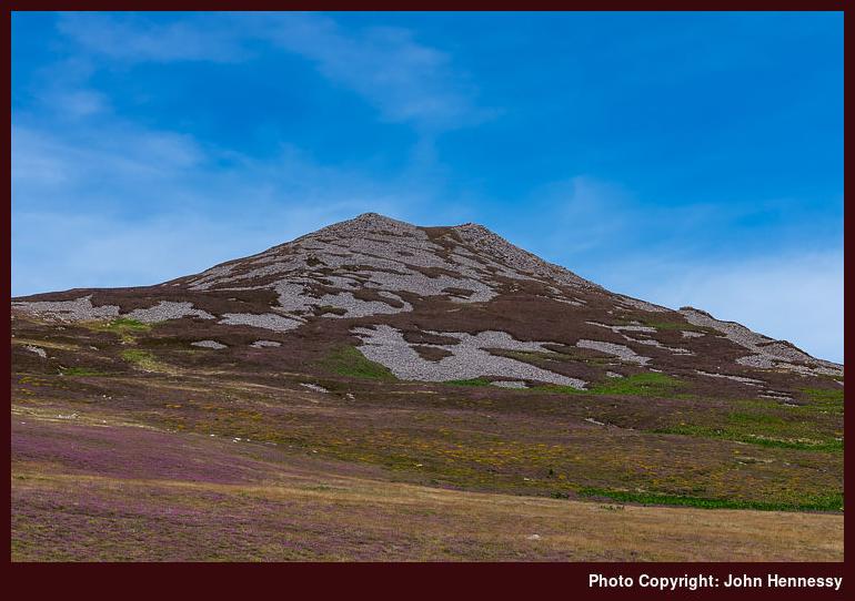
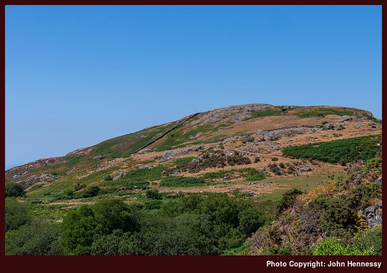
Given the time strictures, I set off out of Llithfaen without delay, not that there was much there to hold me anyway. Its only shop had shut for the day in what felt like a very sleepy place. Thus, this was going to be one of the quieter strolls that I ever have done. It was a case of following the lane by Tynyparc and getting out onto the open hillside, where there are many paths, for this is access land. Rights of way are my normal preference, so I followed one past Caergribin before following a less formal path uphill to the summit with views of Mynydd Carnguwch and Cardigan Bay behind me.
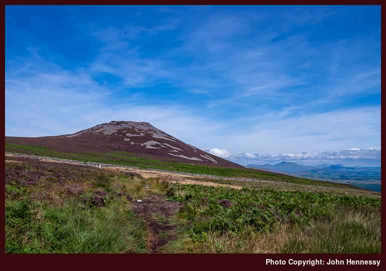
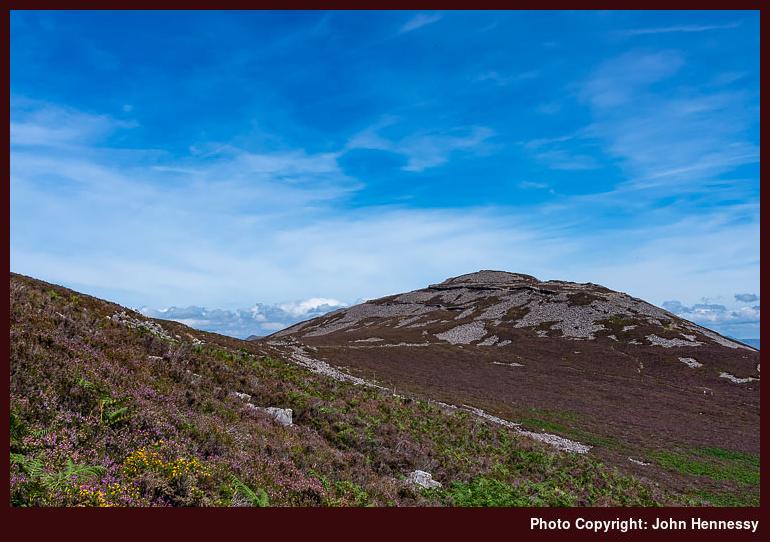
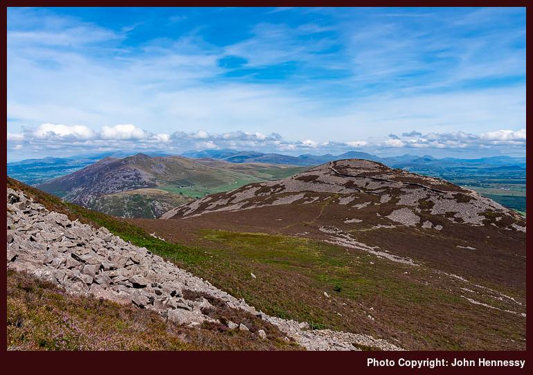
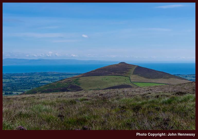
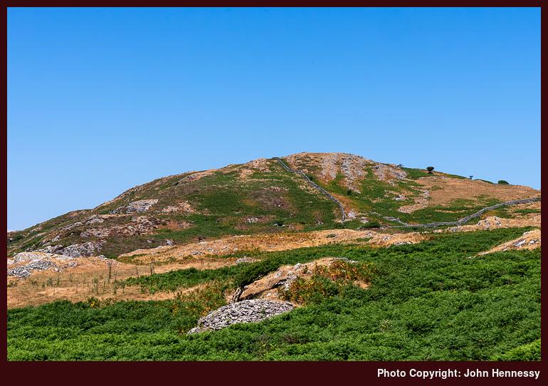
Views of the eastern top of Yr Eifl were to distract me on the way up to the main summit. Even among the stony slopes, walls could be seen on the eastern top. These are the remains of the Tre'r Ceiri Hillfort, a sign that these hills have been frequented by humanity since antiquity. Further to the east, there were other hills to be seen once enough height had been gained. This collection includes Moel-Pen-llechog, Gyrn Ddu, Gyrn Goch and Bwlch Mawr. These take up more land area than where I was and might be worth exploring at some point, assuming a return to the area. The scene was beginning to feel more suggestive of being in more immersive hill country, especially with the hills of Snowdonia in the background.
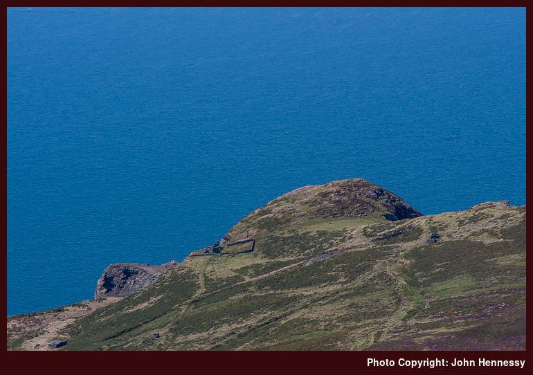
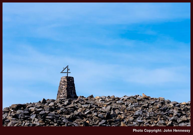
On reaching the main summit, I was greeted by a trig point with the number four added to the top. The letters A and H were added as well, so I wondered if they were the initials of whoever did this. The drop to the sea on the other side is sobering, yet it has not escaped quarrying. Thankfully, I do not recall seeing much in the way of gouges into the landscape, but that might be a different story if I was following the Wales Coast Path, since that gets closer to these active and inactive workings.
My next moves were the subject of some internal debate given time constraints. Visiting the old ramparts of Tre'r Ceiri might have been a no-brainer if it were not for other considerations. Whether I had yet to reject the idea of walking back to Pwllheli or not remains an open question for me now, but I descended to the B4417 in any case. After that, I walked back to Llithfaen again. Traffic was light, and I do know that my mind was set on caution because I caught the next bus back to Pwllheli with time to spare before the next train.
That train was delayed, so I got to spend more time in Pwllheli than I had expected. The delay was heavy, so there was a real risk of missing my connection at Wolverhampton, but I got home that night anyway. Timing concerns mean that it was not the most relaxing of journeys, even with some bright evening sunshine to distract me. The trouble with this section of the British rail network is that much of it is single-track. Thus, a delay to one train can affect others, so there can be all sorts of knock-on effects. In this case, it might have been a passenger falling ill that was the cause of all the trouble. At least, that is what I seem to remember being told when I tried to claim compensation using the Delay Repay scheme.
Even among any qualms, I still began to muse a little over future possibilities. The idea of using Porthmadog as a base appealed to me, possibly because bus connections could address the lack of trains for returning after a weekend getaway. However, a recent look at the train timetable suggests that the Sunday timetable has improved. If so, spending more time near Pwllheli becomes plausible. What I gained was a brief taste of good things, and there are other possibilities in these parts. The railway also serves several access points for other hill walking routes. A bit of advance planning could yield its rewards.
Travel Arrangements
A return train journey between Macclesfield and Pwllheli, followed by a return bus journey between Pwllheli and Llithfaen.
Combining old ways around Barmouth
2022 has turned out to be a very dry year, which probably has helped with my explorations of parts of Ireland. While we could not imagine it at the time, it has come even drier than 2018, a year that then was being compared to 1976. One June evening, when I went around by Sutton Reservoir, I was stunned by how empty it looked. It may have meant that there was no fishing to be had, but that left its banks emptier for strollers like me.
This past summer also had oppressively warm spells. One in July was not only record-breaking, but also oppressive in the extreme for many of us. For others, it was life-threatening, and I was happy to see temperatures cool afterwards. If I was brave enough, this might have been a good time to try camping or bivvying outside somewhere if it was not too hot to walk; it certainly was virtually impossible to work inside. Another spell arrived in August during my holiday in Ireland and got much hotter after I came home, even if temperatures did stay cooler than they were during the July spell.
In the past, I have written that hot weather is not good hiking weather, yet I have gone out walking in higher temperatures. Much of 2018 was warm, sunny and dry until things got wetter at the end of July. Before that, there was a lot of hot weather. Near the start of the month, I headed to Edinburgh for a day spent around Cramond and the city centre. Shady places were well appreciated whenever I passed through them. Normally, I have mixed feelings about tree cover, but they were set aside in the heat.
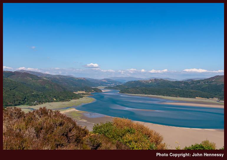
The continuation of the heat did nothing to keep me from heading to Wales more than once. The first of these took me to Barmouth, from where I undertook a circular hike that combined a route that I did in May 2005 with one done in November 2014. You could see from the landscape that the warm, dry weather was taking its toll. Vegetation looked dessicated in places, and heat haze bedevilled any photography.

What I have needed to piece together is my route because it slipped from my memory. Even with photos, this has been challenging to work out, much like the places featured into the photos themselves. This is complex ground, with passes getting names instead of hill tops; you can see what was a priority for the locals in older times. One thing cannot be contested, though: the sea is near at hand and added to any views once the right vantage point was reached.
The Cambrian Way has made it onto modern OS maps, and my early wandering either followed or shadowed it, a major change from the days when publicity was curtailed by worries on the part of mountain rescue volunteers. This was the route that I used to ascend steep slopes before passing Dinas Oleu and Garn. The Cambrian Way was left after me for a while as I went around by Gellfawr, Ffridd y Craig and Bwlch y Llan. This was when the sea views opened up for me, though the hills of the Llŷn peninsula were lost in the haze.
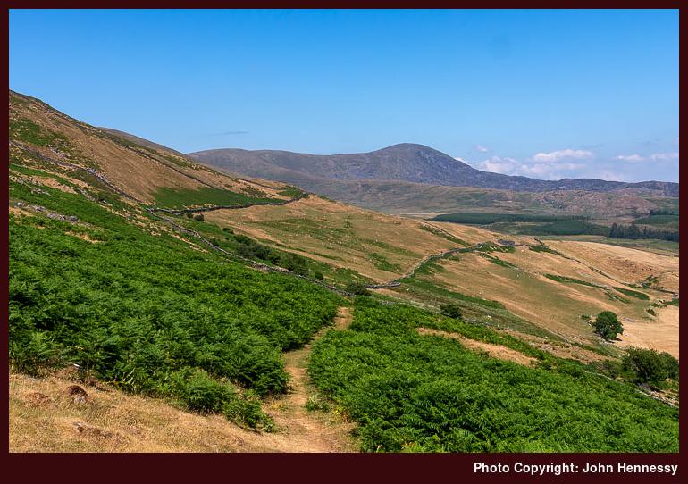
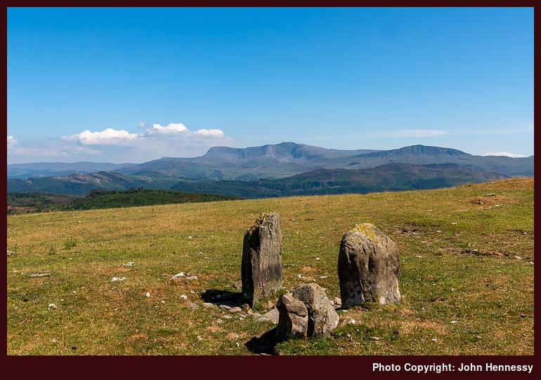
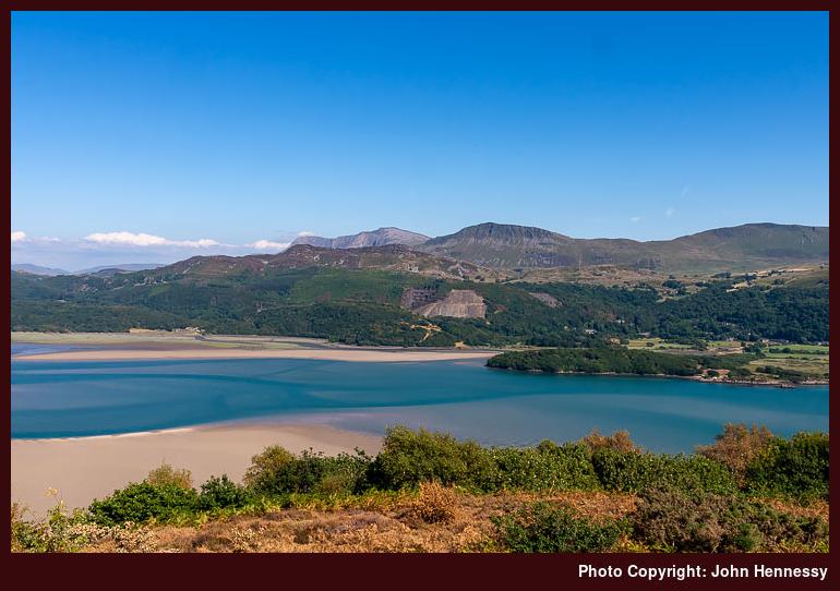
Once over Bwlch y Llan and across the route of the Cambrian Way, different views opened before me. Some of these were just as compromised by heat haze as the aforementioned sea views. That included anything situated to the south of where I was, like Cadair Idris and its immediate surroundings. Other hills like Craig y Grut and Diffwys were not so affected, and also occupied my senses as I made my way towards the Cerrig Arthur Stone Circle. This was something that I wanted to visit again for photographic purposes, even if the time of year and the time of day were not the best for what I wanted to achieve. Another visit in May might not be such a bad idea.
My next staging post was the Panorama walk, and memory haze again affects my recollection of the route. There are a few things that stick for me, though. One was a meeting with overly intrusive dogs around Cutiau, while another was the effect the afternoon was having on my energy levels. At least the shade offered by tree cover helped with avoiding the sun as I continued along the lane, and arrival at the Panorama Walk easily punctuated the way back to Barmouth. There was time to dally in the presence of entrancing views before setting off again.
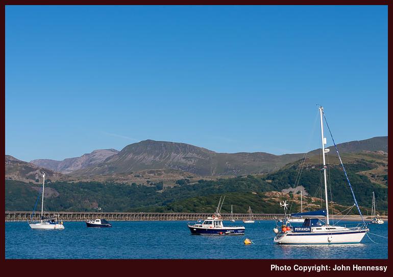
Leaving the environs of the Panorama Walk meant leaving tree cover behind as I went on via Gorllwyn. Barmouth was reached soon enough and with time to spare before my next train. That allowed for some strolling along the shore, taking in views of Barmouth Bridge and what lay beyond it to the east. It was a good end to a walk with its share of tests and delights; there were no regrets.
Travel Arrangements
Return train journey from Macclesfield to Barmouth with a change in Wolverhampton.
Grey at the start and at the end, lots of brightness otherwise
The trouble with trip reports is that they can descend to being a direct factful recollection of a route followed on a day hike. That may explain partly why I have been tardy with sharing these, but the lockdown period of the pandemic has had its impact as well. Sometimes, it works best to leave things a while so that their associated emotional intensity wanes. The vantage point at the time of writing matters too; when there is nothing much happening in one's life, it can result in uninspired scribblings.
This is being written in a time of tumult, when looking back on the past can offer a brief diversion from a life beset by strikes, wars, ongoing works and increasing costs of living. Public transport is not as dependable as it once was, so getting into the countryside now involves a mix of patience and creativity, unless you have your own transport. In fact, many will rely only on their own resources when others appear to be letting them down.
When I went to Shropshire in February 2018, none of this lay in my mind. Then, I was on a career break and contemplating my next career moves. This was a matter of rest, healing and reflection after a few years of upheaval, bereavement and legal works that wore me out more than I had realised. Only later did I learn how caffeine consumption covers up a lot of this weariness.
The prospects for a sunny day out did not look good when I arrived in Church Stretton. Skies were grey and gloomy, and there was a hint of drizzle in the air. None of this deflected me from heading for Carding Mill Valley, and my first encounter with this part of Shropshire may have been on a grey, cold December Sunday, assuming that my memory is not failing me.
Shropshire's hills may be low in stature, but many of the ascents and descents are steep and joint-testing. Thus, there was quite a pull to get into the Carding Mill Valley, and it got tougher on the way up Mott's Road. This did nothing to deter others who were going the same way, persisting as I was.


In time, gradients eased and people peeled off on my going onto a bridleway leading me towards the Port Way. Instead of continuing on towards Woolstaston, I turned left towards the Betchcott Hills. Around there, clouds broke overhead to give more hope for the rest of the day. Clouds were still going to obstruct the sun at times, but there were photographic opportunities to come too.
Farm tracks were what was going to convey me across the Betchcott Hills to Wilderley Hill. Until there, navigation was a simple affair. Near Thresholds, things became a bit less clear, so my route finding was not as smooth as I might have liked on someone else's land. The size of the field meant that it probably was ideal for map and compass work, but I found my way without any untoward encounter or any exchange of cross words.

After becoming more confident about where I was going around Cothercott Hill, views of the Stiperstones opened up before me. There was a catch though because there was a stiff descent down to the road near New Leasowes Farm. Some of the going was muddy, too, especially as I neared the road. From there, I went around by Leasowes Bank Farm by byroad and farm track until I met with another lane.
While I fancied cutting the amount of road walking by following a right of way that lead through Hollies Farm, this did not look like such a friendly option even if it was part of the Shropshire Way. Going through farmyards never appeals that much to me anyway, so I opted to walk the quiet road instead while marvelling at how many larger vehicles were travelling along the one linking Stedment and Stiperstones. The surrounding countryside appealed to me too, which lessened the length of the journey for me.


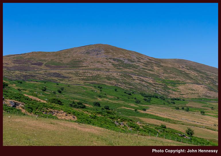
Near Stedment, I turned right to close in on the Stiperstones ridge. On the final approaches to that turning, I noted how old my paper map was. There was an entire farmyard missing from it, so it was time for a replacement. Given that I was backed up by the Ordnance Survey app on my phone, there was no chance of a wrong turn based on old information. A new paper map was acquired soon afterwards.
Gaining height meant opening up more views of what lay about me. If there was more traffic on the road crossing the Stiperstones than what I saw earlier, it largely is lost to my recollection now. What I do remember is seeing a tractor being used to put out winter feeding to otherwise grazing sheep. Seeing the size of it caused me to remark to myself how large tractors had become these days compared to what they were when I was growing up on an Irish dairy farm.


Since it was half-term time and I may have seen more people about because of that, I chose to overshoot the obvious way up to the top of the Stiperstones ridge in favour of a quieter approach. That meant that a father could ask me about a good way up there for kids with trainers. As I often find myself doing, the answer included perhaps vaguer directions than I might have liked to give. The way that I was going might have been one suggestion, but I directed them to where I had deliberately overshot. In any case, I was not seeking company and my line may have been too muddy for them anyway. Not everyone goes out in the countryside equipped for what they can meet; there was a car park and visitor centre not far away, which explains the encounter we had.
My way towards Manstone Rock was the quieter one, and I relished both that and the well sunlit views that going that way offered. In time, I was to join the main track, which was surfaced in a better way for trainer travel, so my instincts had been the rights for that family who I met earlier. The surface may have uneven, but it was not muddy like what I had traipsed. These rocky outcrops probably fascinate kids anyway, since many would clamber onto them. That certainly was what was happening to one concerned mother who was having her patience tested by her boisterous boys around the trig point on Manstone Rock. Quite why Ordnance Survey surveyors placed the trig point upon such a difficult to reach site is beyond me. What is equally beyond my understanding is how they got their heavy equipment onto the thing afterwards. The sighting of these things can amaze.

My own desire was to get back a sense of grater calm. Beyond the Devil's Chair, that really proved to be the case, and I relished this in the late evening sunshine. However, I did not get it all to myself on the way to Snailbeach. Still, I managed to get myself as much solitude as I could by veering away from my preferred route, and the final descent was a steep one.
My heart sinks a little whenever I see a large rambling group out on perambulations. They take up a lot of space if anyone needs to pass them, and I wonder just how present one can be in a scenic spot when chatting with others, as they often do. It also prompts the following question in my mind: can groups like these just get too big to be in the countryside? We are social animals, though, so I can see the attraction this holds for many, and they are often friendly to more solitary creatures like me.
Once I reached Snailbeach, I saw the minibus that was awaiting them, for this was an organised outing. They reached it while I was awaiting my bus to Shrewsbury, and one said to me that they thought I knew my way down. In reality, I only was finding my way on the go, as it is with so many things in life. They left before I did, and I then wondered if my bus would show up, or if I would need to consider later alternatives, possibly from elsewhere. As I continued my vigil, rain arrived, but this was no dampener on my spirits given the day that I had enjoyed. The bus came too, and I started on my return home after a very satisfying outing.
Travel Arrangements
Train journey from Macclesfield to Church Stretton. Bus service 552 or 553 from Snailbeach to Shrewsbury, followed by a train journey from there to Macclesfield. Doing this walk on a Saturday, like I did, now needs a route reversal since later departures from Snailbeach have been removed from the timetable.
Americana
In a previous post, I mentioned Ken Burns' magisterial The National Parks: America's Best Idea and even wrote a few words about this documentary film series. Not living in the U.S.A., I found this quite accidentally when reading an article on either the Outdoor website network (probably the Backpacker part but I am not sure now). Both are part of the same media group and I became a subscriber to Backpacker magazine in 2020. In Canada, there is Explore and they perform much the same function for that part of the world.
Before this, I was inclined to do long trawls through guidebooks for acclimatisation and awareness. This can work but it is not just time-consuming but also can be trapped within one's own predispositions. After all, America's National Parks are known by many around the world so it can be easy to gravitate towards them but there are other kinds of public lands that are amenable to exploration, some of which abut conurbations so they can be easier to reach. Here, I am thinking of what lies on the doorsteps of San Diego in California, Portland in Oregon or Phoenix in Arizona. Two of these came to my notice in a serendipitous manner, the first from a tragic story on the Backpacker website and the last from a Wanderlust webinar.
There also is the usefulness of a more gradual approach taken with an open mind. A concerted effort can and does help but the slower accumulation of insights and possibilities is how I got going in hillwalking in the first place. It happened so naturally that I hardly noticed what was happening and this also brought with it a growing cultural awareness. The same approach might help to restart nascent explorations of North America yet.
All this highlights background realities regarding the scale of North American wilderness as well as equipment choices offered by brands that are not so pervasive on this side of the Atlantic like Canada's Durston. There are times when you need to watch for product placement though and Backpacker's online webinar series from 2020 was a case in point, especially given they erred on the side of overdoing just that at the expense of conveying an experience of the wild places that were featured.
Still, knowing the cultural side of things remains ever useful and that returns me to the feature film series mentioned at the start of this piece. The history of the American National Park system was not that well known to me, even if I was well aware of the influence of John Muir from my reading of his writings during the winter of 2017/8. What happened after him and the issues surrounding the various contradictions of a motto like "For the Benefit and Enjoyment of the People" became plainer to me as I watched the film series.
The tension of high visitor numbers is very clear to us now and it always has been a problem as has allowing people to visit using their cars. That there has been road-building in otherwise pristine areas is part of this, even if that was curtailed in Denali National Park in Alaska by a persistent campaign by one of the park naturalists. The conflict between conservation and having visitor services like hotels and other amenities pervades today and that is likely to continue. Even so, there has been progress too with a different attitude to wildlife meaning that we now need to keep away from wild creatures rather than mingling among them as once was the case.
There is much to learn about another continent half a world away and doing this one morsel at a time makes things stick better. The more gradual approach also allows for added serendipity so you get to find out about places that do not come to light from a concerted effort.
Season of transformation
It is too easy for me to think that autumn is my least favourite season but it is also the one when many transformations happen and when it is possible to think ahead to the next year. The hours of daylight are shorter so there is time to think about other things. Admittedly, the ongoing pandemic stalled any forward-thinking but these still were times of change. 2020 saw me begin to learn new computing languages while 2021 saw me embark on spiritual explorations. Both journeys are still ongoing.
2019 was the last year when thought could be given to a future even if that was devoted to continuing my freelance consulting business. Until that was more assured, I could not think too much about overseas journeying and then the pandemic intruded. A possible trip to Colorado became unthinkable in July 2020. Going to Vancouver, Canada in July of 2019 became a reality because of reading undertaken during the autumn of 2018. The next steps that I took in my career during 2018 were made possible by a career break that itself began in August 2017. The rest of that autumn was taken up with decompression and healing before I could do a rethink at the start of 2018. This necessity was brought about by fatigue after heavy work done at the latter end of 2016 to fulfil my late father's will.
In between the more weighty matters of 2016, much thought was given to mid-winter sunshine escapades that took me to Mallorca in 2016 and Tenerife in 2018/9. It may be tempting to think that a year is done for when you get to its final quarter so that there is an overflow to the following year only for surprises to come. Thus, mid-winter walking trips to Arizona, Malta, Madeira or the Azores can be kept in mind should an opportunity arise.
For 2023, Scotland again offers multiple possibilities and North America also looms again after my watching Ken Burns' monumental documentary film series The National Parks: America's Best Idea. While I probably was after the scenery that was shown, the series mainly was about the history of the National Parks and was just as fascinating for that. Learning about the efforts of John Muir and other actors was as intriguing as seeing the learning journey where lessons that we now take for granted had to be learned on the fly with no precedents for guidance. That the winter of 2017/8 saw me reading the works of John Muir only helped things to resonate with me. It also helped that there was enough scenic footage to restart dreams of Yosemite, Glacier and Rocky Mountain National Park visitations, to name but a few, and the soundtrack was as alluring as the footage.
All in all, I am rethinking my appraisal of autumn. It no longer might be a season of mourning the passing of summertime and springtime, or indeed the year itself, but could be a time of inner growth and expanding horizons. That is how it is starting to appear now. Work for 2022 continues with there being some asset downsizing in progress but time flows ever onward to bring whatever comes our way.