Category: Places Explored
Autumnal and springtime encounters with both Parkhouse Hill and Chrome Hill
Sometimes, places get two visits before I get around to writing up any of them. A few of the trip reports that have made their way on here already have that characteristic, so you get two for the price of one, as risky as that might be when it comes to quickly writing the accounts. As you will find here, it is a chance that I am taking yet again.
This one involves a comparison of different seasons after my finishing the winter, autumn and spring instalments of a seasonal tetralogy written by renowned Scottish nature writer Jim Crumley. The fourth has yet to be published, but the others contain a sense of how seasons can betray their caricatures to produce green winters and white springs, something that he notes in the snapshots he features in these writings. Our climate may be changing, but I still get the sense that what we get is more like daily weather rather than a seasonal pattern.
It also needs to be said that seasons can be cultural as much meteorological or astronomical. That quite possibly is how I got taught about Celtic seasons at primary schools. These apparently have regular starts on the first day of each of February (St. Brigid's Day, spring), May (Beltaine, summer), August (Lunasa, autumn) and November (Samhain, winter). Given meteorological vagaries, I am going to stick with this convention for this piece, so a February stroll is a representative of spring, and it helps that the weather on that day was more like a day in April.
October 2017
First, though, I return to October and that is given a name in the Irish language (Deireadh Fómhair) that means "end of autumn" so you should again hear the effect of what I described above. In the natural world, autumn is a season of change as much as spring can be, and it brings stormy weather too after the supposed quietude of summer. However, the world of the human mind can be quite a different place.
The summer of 2017 became one of my most tumultuous, and it brought me to commencing a much-needed career break. It was in the midst of ongoing renewal and recovery that I went to Sterndale Moor. It was a sunny day after the preceding passage of Storm Ophelia, and there was a camera to try out on the day.
Earlier in the year, I acquired a second-hand Canon EOS 5D Mark II DSLR that I partnered with a lens I bought when I used photographic film. The lens began to show its age on that October day, before it totally failed a few months later. It was replaced earlier this year after it was deemed irreparable due to unavailability of spare parts. Together with life's other events, the expense of the purchase had caused me to delay the new acquisition.
A successful local outing near Macclesfield encouraged me to leave my usual camera after me to make more use of the Canon, so it was with that I left the A515 to go to Earl Sterndale. In some ways, there was not so much that was photogenic as I crossed fields on the way towards a landscape that has been altered by quarrying of limestone. The presence of quarries explains why Buxton is excluded from the Peak District National Park.
A walk from Buxton to Castleton quite a few years ago took me through a quarry on the northern side of the former and brought home to me the violence of the assault on an otherwise bucolic landscape that such industry can undertake. Thankfully, my stroll in 2017 shielded me from much of the horrors of such labours, and Earl Sterndale felt far removed from such things. As if the layout of the countryside can conspire to deceive, that pastoral setting was to accompany me for much of the way from there to Buxton.

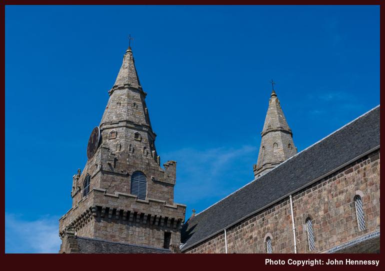
From Earl Sterndale, a public footpath led me through fields around Hitter Hill before dropping me onto the B5053 near Glutton Bridge after I had deliberated on the supposed line of the public footpath give that a farmhouse lying just beneath me. This was to be repeated later, but the next part of my route was easily clear. Deciding against any ascents, I passed Parkhouse Hill instead of ascending it. This was to be a time for getting to know the area better after passing by on several bus journeys and seeing photos in magazines. Any hill climbing could wait, and there were photos to be made.


The path rounding Parkhouse Hill deposited me on a lane that I soon left to follow a byway that took me past Chrome Hill. The theme of passing hills rather than reaching their summits was continuing, with encouragement being provided by a lunchtime start and the loss of evening light. Accompanying quietude allowing for stilling of the spirit, admiration of surroundings and ambience together with a chance for my brain to drift while I made for Hollinsclough.
That again was a quiet hamlet and I left it to head for Booth Farm along clear paths and tracks. Deciding how to continue after that took some thinking and not a little courage to work out the correct way to Thirkelow. Once I had done that deed, there still was a chance of veering off trail, and it took my GPS receiver to stop me going towards Brand End. Earlier fears about such imperfections arousing the ire of landowners were unrealised, and another encounter with the effects of industrialisation lay ahead of me.
The last stretch of my amble took me around land owned by the Health & Safety Laboratory, with attendant signage to stop any wandering into danger zones where experiments get conducted. The floor of the defunct Stanley Moor Reservoir was another perilous place to avoid, and that was passed without much in the way of inspection as I continued towards Buxton Country Park, whose environs ensure a far more amenable feel to the end of my stroll. All was again familiar as I went from there to the nearest bus stop to await the last bus of the day from Buxton to Macclesfield, a feat that was achieved with minutes to spare, so a satisfying day could be reviewed on the way home.
February 2019
As described in another post, the spring of 2019 saw such a frenzy of wandering about England and Scotland that it was very different to autumn 2017 when I was replenishing my energy reserves. Near the start of this outbreak of outings, I returned to Earl Sterndale for a walk close to home in advance of a trip to Ireland.
Looking back through this trip's photos now, it surprised me how long I spent in Buxton before travelling to the starting point for the day's ramble. The morning was sunny and mild, so it might have been inevitable that I made the most of the layover time. In fact, the weather was to remain like that for the whole day.

It also was to be one with many variations on the route that was followed in October 2017. The first of these decided the first stretch of my ramble once I arrived in Earl Sterndale. The re-use of the public footpath from the previous walk would have been expected, but I instead chose a way that added road walking involving the B5053 and that gained the sight of Glutton Dale, which looked similar to many a Derbyshire dale that I have encountered apart from its having a tarmacadam road going through it.
While the reason for this is lost to me now if there ever was one, I do recall the dismissal of the idea of using a right of way from Glutton Grange because the person who was using it was not a walker like myself but looked more like someone of farming stock. Maybe it was my shyness that intervened, but it was to be a day when such decisions recurred, even if more outdoors enthusiasts like myself were around.

On the approach to Parkhouse Hill, there were figures seen to be ascending its southern slopes. When I left the B50553 for a path leading towards it, they were gone, and it could be presumed that they had completed a traverse of the steep-sided rocky little hillock. As it happened, I too was to follow in their wake and reached the top of the hill before deciding to change my route again.
The height gain may have not been that much, but the combination of steep ground and a sense of pronounced exposure was enough to cause me to retrace my steps from the summit instead of descending through the rocky pinnacles. Doing so needed an element of fortitude, but I soon enough found another way: along the hill's eastern slopes a gentler descent was on offer, and it led me north as I wished. As other walkers continued up the hill with their dog, I used this quieter, easier terrain to both continue on my way and regain my composure.
Once down on the lane again, I was to see where the northbound descent led and decided that I had chosen a more sensible route. Because Parkhouse Hill is on Access Land, doubts about footpath maintenance also surfaced. The last thing that anyone needs on steep, exposed ground is an eroded path that offers reduced traction, and I have met a few of those on my ambles. Another summit lay ahead of me, so it was better to have saved myself for that.


Once down on the lane separating Parkhouse Hill from Chrome Hill, there was time for a little refreshment before I sought out the concessionary path leading onto the Access Land encompassing the latter. Before that, a Land Rover driver stopped to ask me if I had a parked car. Having none, the conversation came to an end there and I recommenced my walk.
The way up the southern flank of Chrome Hill was a more friendly affair compared to that of its neighbour. The greater girth had something to do with that, and that was just as well given the higher summit. Though I might have been tempted to continue north from there, the lack of a right of access, let alone a right of way, put a stop to that. The later sighting of a fire demonstrated the wisdom of ascending and descending the hill by the same route.
On returning to the lane, I now reprised the one part of the pair of walks that was identical in each: the section from the feet of Parkhouse Hill and Chrome Hill to Booth Farm via Hollinsclough. Along the way, smoke from that fire on the northern slopes of Chrome was there for all to see. It even caused some fellow ramblers to ask me if I had been on Chrome Hill and if it was alright. In fact, I had seen no sign of a fire while up there while savouring unobstructed views of what lay all around me.

At Booth Farm, the passage of time between encounters ensure the lack of confidence away where a right of way led and the extra activity on the day led me to dismiss the previous route to Buxton in favour of following a lane before leaving it for a more distinct public footpath. Along the way, I could look back towards Chrome Hill, with any fire near there by now a smouldering remnant. My sense is that this might have been controlled burning, as dramatic as it looked, but I know no more.
While still following public rights of way, I continued from field to field and across Access Land encompassing High Edge. From there, I descended by Staker Hill and found my way onto the road leading to Harpur Hill on the outskirts of Buxton. That was preceded by my traipsing through what might have been someone's yard, but there was no associated rancour, and I ambled along the road for a while before choosing to await a bus at a nearby bus stop. The walk had ended in time to allow preparation for travelling the next morning, and the day had brought much satisfaction. It had been a worthwhile second visit to an alluring area.
Travel Arrangements
Both walks saw me making use of service 58 between Macclesfield and Buxton. The 2017 outing saw me use service 441 between Buxton and Sterndale Moor, while the 2019 one saw me travel from Buxton to Earl Sterndale on service 442. The latter also involved my using the TransPeak service to get from near Brierlow Bar into Buxton when a variation of the original route presented the possibility of more road walking than was desirable.
Logjam
One I feature a trip report for an overseas trip on here, chances are that urban strolling gets mixed in with rural hiking. Separating the two has a habit of feeling very wrong even when the the countryside explorations are subsets of what else occupied me. The comment applies as equally to Swedish explorations as much as they do to Aberdonian ones. It might be tempting to move the urban activities into my Travel Jottings and leave the shorter incursions into more more natural surroundings for here but it just feels like I am doing the whole task a disservice so they all end up here instead.
That has its consequences and the Swedish trip report was the cause of getting in the way of adding other content on here. After all, the trip was a six day affair and writing up each day would have proved challenging on its own but I left the whole lot go together. With overseas outings always likely to combine urban and rural, that conundrum is likely to remain but there may be chances for a split just as well. An Easter sojourn in Edinburgh could lend itself to such division and they are some ideas in my mind for purely urban explorations just as well. It all depends on how I feel about things at the time.
Another outcome of the uncomfortable juxtaposition of walking around built-up and wilder areas is that I decided on a name change to cover what is here that little bit better. After all, all my walking and cycling takes me out-of-doors so Outdoor Excursions is now the name you find at the top until I find something else or get in the mood for a change.
As it happens, there have been a few names for this place over the years and Collected Musings of a Hill Wanderer still feels the best even it now longer fits the style of the rest of the website. Maybe, it can return as a strapline even if I mix up the destinations for my wanderings these days. What will not alter is the intended focus on celebrating quality time in more natural surroundings while a better name might come to mind.
More extensive Swedish wanderings
The summer of 2017 was packed with many things, and included among these were two Scandinavian excursions, bookending a period of emotional angst that preceded my undertaking a career break. It was the second of these that took me to Sweden, and it usefully covered up what was happening in my work life from those in whom I did not wish to confide any of the ongoing drama. The trip also offered as much to my inner explorer as it did to my emotional well-being, and there was much to occupy the former, both familiar and unfamiliar.
Arrival and Acclimatisation
My departure for Stockholm came near the end of the first week of my career break, and even that space allowed me to collect myself a little after a trying few months. What I was not to realise was just how much time away from working was needed, but that lay in the future. That the grey skies largely prevailed was of not concern to me, given my other needs.
In fact, my arrival in Sweden was accompanied by the same kind of weather, but it remained dry, which was more important than having sunshine. At the airport, I got a travel card and loaded it with enough credit to last a week, so I could travel on buses, trams and trains within Stockholm county without worrying about having change or buying tickets. It was a system that would come into its own for my explorations.
Its first use was in getting me to my hotel in Lidingö with a change in Stockholm's central railway station, a place that I had last been just over seven years before then. My train journey came to an end at Ropsten, so I then continued on foot, though there was a tram service if I wanted it. Sometimes, finding one's bearings takes precedence, even if I had luggage with me.
A busy road bridge loomed overhead as I made use of a lower counterpart for pedestrians and cyclists that lay beside that used by trams. My added burden ensured unhurried progress as I sampled the surroundings under grey skies before making landfall again and proceeding uphill to reach my destination near Millesgården.
That was sweaty work, but it was not the end of my strolling for the day. Before any such continuation, I needed to check in at my hotel and settle into my room. Apart from the need to find my bearings within the building, that happened without incident, and I was again out of doors. Being unladen this time around meant that I could walk a little quicker and try out other routes.
The major itinerary of the day took me from the hotel to the heart of the city and, having seen the length of the stroll, it convinced me of the sense of getting around by train and tram. Before that lesson was learned, I dropped down to the tram stop to find a cycle trail that would take me back to the heart of the city for some rambling not done since my first encounter in 2010. It processed around port installations before venturing inland to pass Stockholm stadium, the half point of my urban hike.
My goal was to reach Mäster Samuelsgatan, where Kartbutiken's shop is to be found. However, it was closed by the time that I reached it, and a call into a branch of Akadamibokhandeln happened instead. While there was a section featuring books in English and walking maps were to be found, I delayed any purchases until the next day and continued exploring. In any event, most books on sale were published in Swedish, as might be expected.
Even though dull skies curtailed photographic designs, I still wanted to revisit sights not seen for more than seven years. That meant a visit to Stockholm's City Hall, from which good views of Riddarholmen are to be enjoyed. The sun may have tried to break through the cloud cover, another day was needed to see Gamla Stan at its best, so I went back to my hotel by train and tram.
From a City Centre to a Royal Palace
The combination of unfinished business from the preceding evening and the promise of sunnier weather was enough to draw me back towards the city centre again, even if there was a cloudy start to the day, and it remained thus as I crossed the bridge to the train station. A short train ride took to me to either Karlaplan or Östermalmstorg (it could have been any one of these but faded recollections mean that I cannot tell which it was) from where I headed to Humlegården and passed the Kungliga Biblioteket before I left it to continue to Mäster Samuelsgatan to make a visit to Kartbutiken.
The sun may have been lighting my surroundings well by now, but I still spent time in that map and travel guide shop as planned. In fact, what I found came close to the spread of subjects that you would expect from a Stanfords store in England. Consequently, I lingered a while, and I seem to remember coming away with a map that was to come in very useful for the trip's long hike along the Sörmlandsleden.
That was to be two days away, so I again made my way to the city hall to see how the Riddarholmen would appear in midday sunshine. The answer was that it was better lit than on the previous evening, but with more shadows. Evening lighting appeared to be the answer, and the time until then found good use for a short excursion through the local archipelago.

Something that had been missed in 2010 was the presence of boat tours (it might have been that they had finished for the day by the time when I arrived from Södertälje or I just overlooked their presence), so I decided to explore what these offered. In a way, this reminded me of the short excursion around Oslofjord that I had sampled in June, and that may have made me more partial to the idea on that afternoon in Stockholm. What took my fancy was a return sailing to Drottningholm, where a royal palace is to be found. Along the way, I discovered that banknotes that I held over from my previous encounter were out of date and could not be used, but that was no dark spot on what otherwise was a blissful journey.
Since the characteristic shoreside view needs a morning approach to make the most of it for photographic capture, it just as well that Drottningholms Slott is situated in pleasing grounds. One quandary that I had was if I would have enough time to explore the place enough to do it justice before the last boat back to the city centre. In the event, there were no such problems and I had plenty of time to wander about to my heart's content without needing to resort to alternative public transport options.

There was an evening left for city centre wandering on my return from Drottningholm, and glorious sunshine lit the place fabulously. All I needed to do was set off strolling on foot and the city plan was engrained in my memory after being there in 2010, so I was not about to get lost. It was a matter of revisiting old sights and collecting new ones as I pottered around islands like Kungsholmen, Riddarholmen, Stadsholmen and Skeppsholmen. All of that sustained me until the light failed, and I then went back to the hotel for the night, having earned a good deal of satisfaction.
Strolling from Island to Island
Sunday morning began with some wandering about the island where my hotel was located. Handily, there was a nature reserve to be found only a short tram ride away, and the sunshine offered enough encouragement to get me exploring. In some ways, this included elements of aimless wandering, though that is not the whole story, even if weathered recollections make it appear thus.

Others had much the same inclination, but there was ample space for all of us, with solitude on offer during most of my ambling. A forest trail took me towards the shore of Kottlasjön, a pretty lake I was to shadow until I turned north on the way towards Ekholmsnässjön. Much of this was along part of the Lindingöloppet, a 30 km looped walking trail, but there was not so much to see of the lake itself and the sky was filling with clouds. That eventually limited photography, but I still continued towards Gåshaga, though road walking was my lot thereafter. Still, there were brighter interludes and I got to see some passing shipping like the departing ferry from Gåshaga Brygga before returning to my hotel by tram.

All that building cloud brought rain, and there was a midday shower that convinced to get a raincoat that became less useful than I had feared, for that was the only wetting of the day. Sunny skies full of broken cloud cover was what I mainly enjoyed for the rest of the day. That applied as I crossed Ladugårdsgärdet to reach the bridge linking it with Djurgården. It may be an island with a ferry service, but I entered and left it using handy bridges while enjoying the greenery in between these. After leaving, there were plenty of sightings of the place on offer as I continued towards the city centre.
After more city centre explorations, I moved onto Södermalm with a view to reaching Björkhagen since it is the northern end of the Sörmlandsleden, a trail that I was to follow north from Tyresta National Park the following day, and the green space that surrounded it. In the event, I never did get that far, and it might have avoided a later quandary had I done so, but that is history now. The declining light showed me it was time to return to me hotel for the night after a day that became laden with rambling.
A Day of Lakeland Hiking along the Sörmlandsleden
My overseas trips always feature at least one hike, and my time in Stockholm was no different. Complementing all the city strolling was a day spent along the section of the Sörmlandsleden between Tyresta National Park and the outskirts of Stockholm. Getting to the national park involved rail and bus travel, with the latter being a one-way trip that added a sense of commitment to my endeavour.
While the transport changeover at Hansen had been made more pleasant by the proximity of lakes like Övre Rudasjön, the surroundings easily felt more rural in the national park itself. In fact, there was a hint of the agrarian about the starting point for my walk, with hens pottering about freely near what looked like a farmstead.
These surroundings were left after me to enter woodland that brought a certain sense of forest bathing to my day. Signs declared that any fallen trees were left where they fell for the benefit of nature, though I was to find that pathways were excluded from this practice, so there was to be no added element of bushwhacking or any sense of negotiating an obstacle course. All in all, this was to be a gentler if lengthy stroll.


Forest bathing already got a mention, but there was another wetter form available if anyone was so inclined. This was because I was wandering through a lake-studded landscape and the length of my endeavour ensured a similarly long list of lakes that included Bylsjön, Årsjötjärnen, Årsjön, Tyresö-Flaten, Albysjön, Alkärret, Kolardammarna, Öringesjön, Strålsjön, Sandasjön, Ulvsjön, Söderbysjön and Dammtorpssjön. Looking at the names now makes me wonder if I had passed so many lakes on foot during a single day, and that may have been the case.
As I passed from lake to lake, the peace and quiet was striking. After all, it was a Monday, so the weekend had passed, and it was coming towards the end of summer. Having wandered around a city over the weekend, country walking was going to be quieter but, away from lakes, camping grounds and conurbations like Nyfors and Öringe, I was to have more than enough time and space for myself. There even were wilder interludes like the sudden appearance of a snake scurrying across a path at close quarters that awoke me from my reverie.
Even with those extra folk out and about in the evening, their presence hardly made an imprint on the ambience. The same applied to my reaction when my GPS receiver started to act strangely. It felt as if it was trying to tell me that I was walking too far, but that was not how I was feeling at the time. Fatefully, I decided to switch off the device and resolve to depend on a paper map and any waymarks for as long as was needed.
As the evening wore on, thoughts of leaving the trail early were entertained before being rejected. After Öringe, my surroundings regained a wilder feel, and that is how it remained as the time to sunset ever reduced. Human encounters were occasional and hardly intrusive. Conurbations were near yet felt so far away.
Eventually, dusk came upon me and I needed my head torch, though picking out flashes of red paint on tree bark in the gloaming became an ever more challenging pursuit. My GPS receiver was missed, but I still got to the golf course near Dammtorpssjön without too much difficulty. It was on the way from there until the end of the walk that fatigue and scepticism finally caught up with me.
The result was the descent of a sense of uncertainty despite the present of street lights; they looked so out of place that their presence threw me a bit. Even so, I remained largely on track until one final junction, where a well-lit sign with an actual map was overlooked in favour of a signpost that sent me along a track to a dark roadside near another outdoors centre. After a little exploration, I started on my way back to the hotel by bus before continuing the rest of the way by rail.
A Fleeting Encounter with Gothenburg
The preceding night’s wrong turn must have weighed on my mind, for I returned to the scene the next morning. A daytime visit set this to rights, even if time did not allow for more complete closure of whatever was rumbling in my mind. That had to be left behind me.
The reason for the aforementioned time limitation was my wanting to visit Gothenburg on a day trip from Stockholm. High-speed train travel made short work of the crossing, even if the later departure time reduced my time in Sweden's second most populous city to less than two hours. On the way, there was much window gazing and the quiet ambience allowed for some reading too.


Even so, there was enough time for me to get my bearings and find some nearby leafier parts. These may not be as accessible as Stockholm, but I have spied some tempting green spaces on maps since then, and there is an offshore archipelago. Making use of such possibilities will need a return visit given the time that I allowed myself. In any case, the added warm sunshine left me with some pleasing photos, so they will suffice until then.
Continuing a Career Break
My time in Sweden was coming to a close, so I went back to Stockholm for one more night. The return train journey was just as peaceful as its outbound counterpart, and there was no need to rush the next morning because of the timing of my flight back to Manchester. It helped that there were luggage lockers at the central train station, and I popped out for one last visit to the city hall before making for the airport by train. It was time to leave Sweden for the rest of my career break, a longer journey specked with more outdoor wanderings that have yet to be related on here.
Travel Arrangements
There was so much shuttling around Sweden's capital by bus, train and tram that the individual journeys get too long to list. Instead, they appear in the main body of the narrative, and it is the return boat trip between Stockholm that gets a special mention. That needed the payment of a special fare while the city's Access card was charged for seven days to pay for my land travel needs (they can be purchased at the airport).
The longer journeys are easier to list, and the return flight between Manchester and Stockholm was the longest of these. Travel to and from airports was by train, and the Arlanda Express did what I needed in Sweden. The services of SJ were used for the return train journey between Stockholm and Gothenburg, though MTR Express also operates the same route, albeit with different stops.
A busy spring
The continuing non-availability of Northern train services on Saturdays due to industrial action became such a source of personal confinement that their restoration produced such a dramatic effect. From February until now, I have been away most weekends, making use of the increased opportunities for train travel. The promising weather helped too, even if it meant that water supplies were not getting replenished as required after last summer's extended spell of hot and dry weather.
The result was that Yorkshire got a lot of attention throughout February and March. It started with a visit to the North York Moors on a sunny day in February that felt more like summer than the actual time of year. Roseberry Topping was revisited, as well as nearby hills, as I traced out part of the Cleveland Way on a circuit centred on Great Ayton's Train station.
Other circuits were followed by train as dictated by the extent of day ranger ticket areas. Two of these took me between Leeds and Carlisle, so it might have been inevitable that I ended up getting ideas for walking outings as a result. The departure point for such attentions was Settle, since I had not passed Attermire Scar or visited Malham and its nearby tarn for far too long. Sunshine may not have been in ample supply through my walking rounds, so another trip to Malham Cove cannot be ruled out, and it could see me going to Skipton on foot as well. There were two outings in total, and there already is another in mind.
It has been a spring full of city visitations, too. In the north of England, the tally included Newcastle, Leeds and Sheffield and Scottish cities like Edinburgh and Stirling got their share of attention too and there even was a trip to Cardiff for some wandering by the River Taff. More will be written about these below, while Newcastle saw more wandering than other northern cities as I pottered along by the River Tyne on the way to Wallend using part of Hadrian's Wall Path. That again was a quieter stroll, and there was much to savour on a journey from a city centre to greener parts of its suburbs.
An elongated Easter weekend allowed for a longer stay in Edinburgh that has been in mind for some time, and there was a truncated effort in 2017. 2019 saw no such intrusions, so I was there from Holy Thursday through to Easter Tuesday as planned. That allowed for a lot of city rambling, and there were two visits to Linlithgow. Hill wandering featured too, and days were spent among the Pentland Hills and doing a round of the hills encircling Glen Sax. Along came reminisces and silly daydreams entered my mind, but the time spent around a city where I spent part of my university years also became a chance to deal with any episodes of unfulfilled promise that returned to haunt me.
When I moved away from Edinburgh in 2000, there may have been an element of unfinished business that drew me back again and again to somewhere for which I still hold much affection. The 2019 version of the same was a suboptimally composed photo on Calton Hill, so I returned on the Mayday bank holiday weekend to set that to rights. Other sights like the city's botanic gardens and Corstorphine Hill Local Nature Reserve were frequented too, and the latter featured on another visit during the following weekend.
Though I was bound for Stirling, a stopover in Edinburgh did allow me to revisit The Royal Mile and Corstorphine Hill in good sunshine for the sake of a little closure of what was becoming like an Edinburgh trilogy. Stirling saw plenty of sauntering with photographic pursuits in mind, but the prospect of a walk among the nearby Ochil Hills remains outstanding, so that could be another excuse to go back up there again.
After all those weekend forays elsewhere, it now feels as if some quiet time at home is in order, and that pervaded the Spring Bank Holiday weekend aside from the aforementioned day trip to Cardiff. Others making the same journey had the attendance of a Spice Girls concert in mind, but designs were far more demure as I avoided bands of cyclists to amble by the River Taff to take in the spring foliage on trees around Bute Park and Llandaff on a sunny afternoon that could not be enjoyed further north, such was the available weather. The summer awaits, so only when that arrives will its roaming be revealed.
Visiting castles and coastline around Aberdeenshire
Sometimes, thoughts cannot be expressed as envisaged. For instance, it might have seemed a good idea to compare 2010 and 2017 in this post, but it did not fit well and instead inspired another one. The choice of years could have included 1997 just as well, since that year saw the first of three visits to Aberdeen, and it is the third of these that gets related here.
Another factor that inspired the 2010/2017 comparison was the that both years bookended a period spent working for the same employer and the fact that my enthusiasm had waned became apparent to me during my spring sabbatical break. In a vain effort to ward off an eventual and inevitable resignation, I planned some excursions: the first took me to Aberdeen for the Spring Bank Holiday and June saw me go to Norway for nearly a week.
A trip into a bookshop during the 2010 stay highlighted how many castles there are to be found in Aberdeenshire. That partly influenced what I got to explore during the 2017 getaway because both Dunnottar Castle near Stonehaven and Crathes Castle near Banchory were visited during the weekend. The former of these lay on my wish list for a number of years and has graced many a calendar, so I had designs on some photography too.
Getting Away
Before my career break and subsequent ongoing period of self-employment, an annual leave allocation was something to be managed carefully. Thinking back to my employer from 2001 to 2010, there was a possibility of buying two more weeks of holiday every year that I no longer had between 2010 and 2017. For what life had in store for me in 2016, the extra time off from work would have been very valuable, but it was not to be had. As it happened, I never had recourse to buying additional days of holiday during the first decade of the century in any case and the act added more personal independence than you might think.
That rationing mentality meant that I needed to leave my departure to the end of a working day or lose one day out of the weekend. After all, the journey from Macclesfield to Aberdeen takes between six and seven hours by train so it was little wonder that I booked one off from work for the 2010 escapade. For an evening departure, another approach is needed with overnight travel being a possibility that could leave one more tired than is ideal, especially if coach travel is involved. Overnight train travel can be an expensive affair that gets booked up before a bank holiday weekend.
Those considerations led me to considering air travel instead, especially given the way that the cost of train travel has risen in recent years. After looking at schedules, I found Flybe flights that did what I needed despite a delayed departure caused my needing to retrieve my mobile phone from the office desk where I accidentally left it. That scuppered a planned train journey, but a taxi did the needful in its place. The flight itself was late anyway, so getting into my hotel involved ringing a doorbell to secure access to the building. Aside from those very minor hiccups, all went smoothly.
Wandering About Aberdeen
After a decent night's rest and a good breakfast, a day of strolling commenced. This was to have two parts with the first spent around Aberdeen and the second taking in Stonehaven. The pervading ambience was one with the same sort of peace that I tend to find along numerous North Sea coasts, regardless of their being in Northumberland, Lothian or Aberdeenshire. It was a vast contrast to the sensation associated with a terror attach in Manchester earlier that week or with the Grenfell Tower fire a few weeks later. There are times when life can bring too much despair so it is good to step away from that for a while.

Oases from such horrors can be found in unexpected locations and Union Gardens in the heart of Aberdeen is but one of those. It may be found next to the city's main thoroughfare but the fact that it lies below street level ensures that a certain sense of sanctuary can be found there. All of my wanderings around the city have found me drawn to the spot since I discovered it in 1997. In 2010, a day of city strolling began there with a looming threat of reconstruction to create a street level park that obscured any signs of a railway or a tarmacked dual carriageway. Thankfully, that scheme came to nothing and the park remained there in 2017 for the start of another day of stravaiging.
The quiet atmosphere on that sunny Saturday morning did its best to belie not only my location but also the times in which I was living. Simpler pursuits like photography caused me to linger until at least until the departure of council workers attired in high visibility clothing before making some photos, but that was a mere passing intrusion. Bright colours like yellow and red did not fit my intended palate of green, blue, brown and grey, so I awaited their exit before gaining my fill of satisfaction and more architectural delights awaited revisitation.

After climbing steps up towards His Majesty's Theatre and taking in a statue of William Wallace, I continued on my way to the statue of another hero from Scottish history: Robert Bruce, one-time king of the country after winning its medieval wars of independence. Another landmark lay adjacent to its situation in the form of the once independent Marischal College that now forms part of the University of Aberdeen. If I was not bound for Old Aberdeen, it may have been worthwhile to try photographing the lofty edifice from a better vantage point than its immediate environs, whose low level presented many challenges despite such successes as the photo you see above.
It only took two of the charms of Old Aberdeen to draw me there again but there happens to be more to the area than those. The first was King's College, another part of the University of Aberdeen that once was an independent institution, and the second was St. Machar's Cathedral Church, one of a small number under the custodianship of the Church of Scotland that retain that designation.
The mention of King's College takes me back to 1997 when I was based near there for a chemistry conference during the very week after the death of Princess Diana and the displays of public grief that it provoked. Aberdeen then offered respite from the vagaries of the world and it has become a theme. The village like atmosphere of Old Aberdeen makes it a pleasing place to visit with its cosy-looking houses clustered around larger university buildings, such of which are less elegant modern constructions that are kept away from the older architecture.
It took until 2010 for me to reach St. Machar's Cathedral on a damp grey night, but a repeat visit happened the next day, though weather conditions were not so permitting of photographic activity. 2017 made up for that, though I did need to allow a wedding party its privacy as it entered the church for a nuptial service. Such events are to be expected, so a little patience and so time exploring other vantage points was all that was needed before I had the churchyard to myself again.
The route that I had taken from King's College to St. Machar's Cathedral had been an indirect one that took me through part of Smeaton Park, and I was to sample more of the place after leaving the churchyard. The weather had lured many others into the park, and I was surprised to see a Segway tour being led along its paths. My own strolling took me along the south bank of the River Don and away from those other users.
Following the river, I hiked east to the Brig O' Balgownie and from there to the A92. Crossing that, I headed for the Donmouth Nature Reserve, lured by the appeal of being near where the Don enters the sea. Possibly because of geographic realities such as tides and the presence of mudflats, I did not venture so close to such a point but chose instead to continue south along the Esplanade.
As I did so in typical North Sea coastal peace and quiet, there were ships lurking in the sea haze. Some were stationary while others were passing. Others were out strolling, but there was enough space for all of us with an amusement park drawing most of those who were attracted to the shore.

Most of the way to Footdee, I remained on the solid walkway, but I occasionally ventured onto the sand too. For reasons of human occupation and disordered building, my ambling around Footdee took a meandering course until I pottered out along the North Pier and then back again. Quayside rambling soon enough brought me to Castle Street in the heart of the city. Along the way a Northlink ferry had been spotted, a reminder that I never ventured north to either the Orkney or Shetland islands. However, another destination beckoned more immediately and that was where I went next. Island exploration was to be left waiting.
Seeing Another Stretch of the North Sea Coast
My pending and momentary departure from Aberdeen brought me to its train station and a reminder of contemporary events. The sight of armed police officers at a city station far away from the site of a preceding terror attack in Manchester did not strike me in the same way as the removal from public use of luggage lockers at Fort William's train station. Then, the overriding impression was one of overreaction, but my mind was full of other thoughts in 2017. All I did was to catch a train to Stonehaven without greater contemplation of the situation.
Stonehaven may be but fifteen to twenty minutes away from Aberdeen by train, but it might as well have been much further for the weather was very different when I got there. The skies were clouded and grey as I covered the longer than expected distance from the town's coastline to its shoreline. At times, the air even felt damp, but I remained undeterred from continuing as far as Dunnottar Castle. Others were doing likewise since this is a well known Scottish landmark.

Given enough time, the cloud cover broke in concert with the passing of any light rain showers. These are times when a seemingly hopeless quest becomes fruitful and a momentary vigil gets its reward. For my own, I sought a quieter spot where no one else bothered to loiter by the dramatic coastline. All it took was a few-minute southbound walk from the start of the path leading to the castle itself for that is where most had congregated without designs on further coastal exploration.


In fact, my mind started to wander further along the coast than I did. It might have set to wandering as far as Montrose but my lack of time and equipment ensured that I did not do likewise. The cause had been the dramatic coastal scenery and there was a tempting path leading south, but my self-discipline held.

Though coastal views were hazy, brighter skies accompanied my return to Stonehaven. There was a brief stop at its war memorial before I descended to potter along the coast where another reminder of ongoing political tumult lay: election posters for the then incumbent SNP MP, Stuart Donaldson. He subsequently lost the election, but that incursion of world events was left after me quickly as I ambled up the coast before stopping in the town centre for some food and making my way to the train station again. Once back in Aberdeen, I returned to my lodgings for the night after what had been a fruitful day.
Following an Old Railway Alignment
While its predecessor was divided between two pieces of recreational business, Sunday's wandering was to consist of a single thread: walking the Deeside Way from Banchory to Aberdeen. The cause of my going to Banchory after attending to a matter that morning was the proximity of Crathes Castle, but that proved to be a sideshow from the main activity of the day.
The Deeside Way extends from Ballater to Aberdeen, yet it appears that the section going east from Aboyne to Banchory is not marked on OS maps while other parts are indicated. It was not my intention to walk all the way to the trail's eastern terminus, but the sunny evening led me along all the way to Duthie Park where I arrived in the gloaming. The decision had been made with serendipity, but it also could have been said a long walk was in order given what was happening in my life back then.
The start of my hike was a grey one, and I even reckon that the weather was no different in Aberdeen, though a lack of photos and the effect of other events on my recollection both mean that I cannot be sure. In any case, the city in question was left after attending to a matter and I pottered around Banchory before making for the River Dee where I met with the trail that I was to follow for all the remaining hours of daylight.

Once I was on my way, the cloud cover began to break to allow the sun to work its magic from time to time. By then, I was strolling along the bed of the former railway line with the River Dee beside me. At times, the pastoral nature of the surrounding countryside was on show though I was among trees for much of the time. More vintage installations like the Royal Deeside Railway, a heritage line, and an event like the Crathes Vintage Car & Motorcycle Rally added a momentary feel of an earlier age, even reminders from my own youth when vintage rallies were momentary diversions from contemporary life.

Leaving the trail after me for a while, I strolled into Crathes Castle and that was what drew me this way in the first place. It also was an encounter with another heritage attraction, albeit one that was nearing the end of its opening hours for the day. My start had been an early afternoon one and the sun had drifted behind clouds, so a vigil began in the hope of our nearest star escaping what might have felt like its cloudy prison.
As I did so, a request for a photo came my way from a mother who spotted my DSLR. Unfortunately, the sun was coming out right then, and I was not as cooperative as I otherwise might have been. The above photo came at the cost of someone else's disappointment, but others had done the desirable before me, so that was one consolation.
Disappointing others does not come readily to me, so I was happy to have some solo time afterwards. This allowed me to move on from the moment a little and return to the Deeside Way. There was a choice to be made about what to do next. Quite why I rejected the possibility of returning to Banchory is lost to my recollection, but I chose to continue east. Maybe there was an urge to explore a little more.

While the Deeside Way uses the former railway alignment for much of its length, there are deviations but these, thankfully, are well signed. That notably helped near Milton of Crathes, and I was sent along parts of the A957 and A93 near Crathes. In fact, the section between Crathes and Drumoak shadowed the A93 and made it much less of a wild walk, though the road and the trail both were quiet at this part of that Sunday. In fact, this was the prevailing mood for the rest of the walk.
At Drumoak, I was tempted to await a bus to Aberdeen but instead chose more walking and the Deeside Way also left the course of the old railway until not far outside Peterculter. Going this way also meant that thoughts of bus travel needed to set aside for a longer period, but the feeling of being out and about in the quiet countryside was more than enough reward.
Going along a narrow lane leading south from Drumoak brought me onto an off-road track that took me through forest and field before returning me to tarmac again. Some were using the facility for dog walking, but that was no intrusion and quiet lane walking followed on a blissfully peaceful evening.
At Coalford, I returned to the railway alignment near where beef cattle were standing on a part that without any right of way. It was a curious scene, but I did wonder at any damage that might be done by leaving such hefty beasts traipse around the embankment as they were doing.
My mind had other things to occupy it. Mid-evening was upon me and the prospect of fading daylight loomed large. Nevertheless, I strode onward with tiring limbs. Every landscape feature was noted as a progress indicator and there were information boards describing former stations that could be checked off against my map as I went along.
After all, this ended up as a purely suburban railway in its last days, but there was a reminder of modernity as I was directed to plod across what now is a newer section of the A90. Though the landscape was scarred by the then ongoing construction, the River Dee remained in view and gentler surroundings lay ahead of me.
After this, light began to decline as the distance to Duthie Park became ever shorter. There were others about who were snatching a quick stroll before darkness fell, a practice that I also witnessed in Sheffield last November and December. Eventually, any thought of leaving the trail could be vanquished by its providing the clearest route ahead and that got me to its end near the aforementioned park.
There was a brief visit to the park that left me wondering at its being left open to the public at all hours, something that often is not offered by some of its Cheshire counterparts. The idea of seeing the place in daylight remained as I then went through the streets to my lodgings for the night. It had been a long hike accompanied by lengthy peaceful moments that were sorely needed at the time. Even a passing bus did little to intrude on that overriding ambience.
Returning to Real Life
The next morning, I arose to see grey skies overhead and largely is how things stayed. Even so, I still revisited Duthie Park before heading to the city's airport to commence my journey home. The sun did struggle to break through the clouds but without much in the way of success. In its own way, it may have planted the idea of another visit in my mind.
Life has gone elsewhere since then though and the summer of 2017 was a dramatic one for me. There may have been trips to Norway and Sweden, but the season is remembered for the emotional toll of the events that led me to begin a career break dominated by recovery and re-energisation.
A renewed enthusiasm for living has resulted as much as a new way of working for a living that better suits my situation. It is a reminder that nature's soothing embrace cannot work on its own but that you may need to do something constructive to gain a better outcome, not that such a lesson stops me from exploring any countryside as should be apparent from this blog.
Travel Arrangements
Taxi ride from Wilmslow to Manchester Airport. Return flight from Manchester to Aberdeen. Return bus journey on route 737 between Aberdeen Airport to Aberdeen city centre. Return train journey between Aberdeen and Stonehaven. Bus journey from Aberdeen to Banchory. Train journey from Manchester Airport to Macclesfield.