A much needed walk from Tideswell to Hathersage
It is remarkable what lingers in your memory and what gets lost. In the case of 2016, it has been how heavily life weighed on me. Pleasant escapades such as a January afternoon stroll along by the Macclesfield Canal or its equivalents during February, a day spent around Tatton Park and a weekend spent in Stirling, and an April weekend in London somehow become lost to recollection. It is as someone erected a barrier that only a photographic archive can dismantle.
It also might have been that times were different before the global political upheavals of 2016 revealed themselves. Thus, life might have been less loaded with such consequent concerns. What also lay ahead was the full extent of the ongoing legal works pertaining to my late father's estate that I was to blame for leaving me feeling exhausted. There was another factor that became more obvious later: what I saw as my day job.
A new role was not going as I would have liked. The hoped for transition was disrupted by unexpected occurrences like invites to senior management meetings and a colleague at work taking over part of my brief without asking me beforehand. This was the poor start from which I would not recover and people I knew were to leave the company too, including my own manager. The unsuitable situation eventually would lead to my leaving the company myself in 2017 to take a lengthy career break. It only is now that I am contemplating the next steps in my career in light of changed circumstances after an inheritance that brings its own continuing responsibilities.
In light of all this, it may come as little surprise that my outdoors wanderings became less frequent over the course of the year. The effect was there to see around Easter 2016 though, with only an Easter Monday afternoon trip to Tideswell and nearby Litton. The weather might have had something to do with it too, since there were many clouds around during that circular stroll. A subsequent bus ride to Sheffield took me by places like Foolow and Eyam that I was to visit within a month. Earlier in the year, there had been a journey to Chesterfield that took me by those places too, and there was an ongoing consultation about the future of Derbyshire's subsidised bus services that thankfully ended with most of them retained.
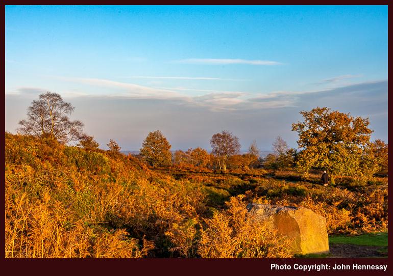
Returning to that Sunday in May 2016, my objective had been to follow part of the White to Dark Way after a fashion between Tideswell and Hathersage. Because of the mixture of weather that accompanied the preceding Easter Monday encounter with Tideswell, I fancied seeing it again. Handily, I had the right day for doing just that.

Unusually for me, I took a roundabout way to get to Tideswell. The main cause was the Sunday bus network in Cheshire and Derbyshire that forced a journey via Bakewell. Having some time between buses meant that I could relish the way that the sun fell upon a pretty place. That was not all, since I was to pass Monsal Head and see down the throat of Cressbrook Dale. The latter sighting was set to alter my walking route after I saw it. The mix of a narrow green valley having steep sides studded with limestone outcrops is one that I find hard to resist.

In fact, I could have avoided Tideswell if it had not taken my fancy because the bus passed through the village of Litton where I could have alighted. Tideswell's allure held, and I spent a spot of time there before returning to Litton on foot via a quiet lane. The sunshine was to hold all day, so there was little need to focus on a single objective. There was plenty of time to savour more than one, and many would present themselves.


The stroll from Tideswell to Litton reprised that followed on the preceding Easter Monday visit. There may be a nagging doubt that I did not follow Church Lane all the way, yet I now reckon that I must have done, despite a fading recollection. What is not lost to memory is what I did next. The White to Dark Way may continue along Mires Lane for a while, but I wanted to savour both Tansley Dale and Cressbrook Dale after what I saw from the bus, so I went around by those. Though clouds blocked sunshine at times, surrounding visions were heavenly as I continued down Tansley Dale and then northbound along Cressbrook Dale; April 2017 would see me go south along the latter of these. For a sunny Sunday, everywhere was strangely unpeopled, and any sign of humanity was to thin out more as I went on my way. For a spot of undistracted mellowing of mind, this was just what was needed.

At the northern end of Cressbrook Dale, I met again with the A623 once more near Wardlow Mires. This is where I spotted the enticing sight along the dale from the bus taking me from Bakewell to Tideswell. After passing through a farmyard, crossings of multiple fields were my lot as I passed Stanley House and Silly Dale on my way to the village of Foolow. The names may arouse predictable thoughts in anyone with a command of English, but they did nothing to stop me pausing in Foolow to partake of some refreshment before more field crossings conveyed me to Eyam, where I again stopped for a while.
The reason this time was different, for this is a pretty place famed for what happened here during the Black Death when the Bubonic Plague visited by way of cloth bought in from London. The whole unhappy episode has not been forgotten, as you will find if you pay the village a visit of your own; it acts as a reminder that life can bring bigger problems, something that can keep life's challenges in their proper perspective. Other folk had gathered around the village in the sunshine, and I indulged in an ice cream before continuing on my way.


If the accumulation of humanity around Eyam had been intrusive, there was a cure at hand in the form of a steep, sweaty ascent. Such things are adept at dissuading any such throngs from dispersion throughout the countryside. In the event, there was no such feeling of crowding after the largely solo traipsing that had been my lot until then. There was more to follow on the way to Hathersage train station. Late afternoon sunshine delighted as I went around by Highcliffe, Bole Hill (two of these are marked on OS maps), Sir William Hill, Eyam Moor and Highlow Bank. Peculiar names continued to accompany my saunter, and High Low actually would mean "High Mound" rather than the tautological curiosity that it suggests.

After losing height, I reached Highlow Brook and saw some folk pottering along tracks, but I left them after me to continue towards Hazelford where I again reached tarmac. As I did so, some muddy conditions were encountered in woodland before some more field crossings. Once on a metalled lane, my mind was focussed on reaching the train station to avoid a lengthy wait for the next train to Manchester. Thus, I was happy to reach the B6001 that would convey me to my destination. Leadmill and a bridge over the River Derwent acted as indicators of progress as I strode along, willing the sight of a railway bridge to appear sooner rather than later. The sun remained, and the required sight rewarded my patience. Others were found waiting too, so a train was due, and I had not so long until I was on my way back home again.
It was the start of a run of walking excursions that continued throughout that May. The following evening saw me head out around Tegg's Nose Country Park near Macclesfield. An added impetus for that may have been my getting a late night phone call about some events in Ireland that affected my affairs over there. That intrusion may have been unwanted, but the incident itself was a passing one that so far has seen no repeat. Nowadays, it scarcely registers in my emotional memory; time really can heal when given a chance to do so.
Travel Arrangements
Bus journey from Macclesfield to Tideswell with a change at Bakewell. Train journey from Hathersage to Macclesfield with a change at Manchester Piccadilly.
A weekend stay in the Tirol that should have lasted a week
Recently, I finished reading Kev Reynold's Walking in the Alps, which was acquired while creating an article on the Pyrenees and the Alps for the travel section of this website. Given the size of the European mountain area in question, it only ever can make a starting point for any explorations. More detailed guidebooks are needed for further planning.
Still, an overview has plenty of uses, and I wonder how well I consulted the volume in question before my 2015 trip to Switzerland and the 2016 one to Austria that is the subject of this post. The fact that the Alps cross many borders to be in France, Italy, Germany and Slovenia as well as the principality of Lichtenstein means that a lifetime of exploring scarcely scratches the surface of what is to be found among them. Thus, only seeing a little may have to do. So far, there have been memorable days doing just that.
My Austrian trip verifies this thought in many ways. It was a weekend visit, albeit with two added days, that left me torn between so many possibilities. Basing myself in Innsbruck meant that so many groups of mountains were nearby that I struggled to decide between them. A four-day encounter never was going to be enough to even sample a little of everything that is close at hand.
Spending a week there would do the Tirol more justice. Mountains are looming all around Innsbruck and I only got to the Nordkette, leaving the likes of Patscherkofel for another time. Of all the surrounding valleys, Zillertal got a visit, while others like Stubaital needed to left aside. It was a choice between spending more time between fewer places and hopping from one to another, making any visits very short affairs. The former always appeals more to me, so I left many reasons for a longer return trip should the opportunity arise again.
Meeting with a Mixture of Weather
By going at the end of May, I was hoping to avoid the elevated temperatures of high summer. As a form of reassurance before the trip, I was checking an Innsbruck webcam and weather forecasts in the hope that sunny scenes would greet me, but mixed weather meant that grey skies often were to be seen. The run of such weather was not to halt on my arrival, but it did nothing to stop me coming away with nice photos and good memories.
There was a brief encounter with Bavaria on my way to and from Austria. My time in Germany on both Friday and Monday saw periods of clouds and warm sunshine. The necessity of onward travel meant that there was little time to savour the places that I passed on my way, but the sights of evening sunshine lighting up the neat pastoral countryside over which the plane flew on my way home remain with me.
Austria's weather was very mixed when I was there. Friday afternoon was a sultry scorcher as I made my way from the train station to the hotel. Thickening cloud cover cooled things for some afternoon and evening strolling, but eventually brought heavy rain with thunder and lightning when I was retiring for the night. The time at which the latter came down from the overhead mountain tops, where it had been in the preceding hours, thankfully meant that I avoided a soaking.
Saturday was brighter than Sunday, so the former was a better day for photography. Morning sunlight accompanied more strolling around Innsbruck before a journey to the heights of the nearby Nordkette. While there, a mixture of clouds and sunshine gave way to rain for a time before drying up again. Heavy rain punctuated the time after my return to Innsbruck before it too departed.
The trend for Sunday was one of continued deterioration from a dry period with some sunshine to rain and wind before a return to the former later on in the day. That did nothing to halt my trip to Mayrhofen in Zillertal for some exploration. Sunny spells turned to rain, and then that changed to teasing momentary spouts of sun on nearby slopes and tops. Rain returned later, this time with wind, towards the end of my stay in Zillertal, but there was enough satisfaction to make the possibility of returning a pleasing notion.
Monday saw a rain-accompanied departure for home. Final saunters around Innsbruck needed the umbrella with which I had furnished myself, both on a walk to the Tyrolia bookshop and then to the train station. The sentimental might be tempted to call this a tearful goodbye, but it was yet more reason to be thankful for any spells of sunshine that I had enjoyed; this need not halt thoughts of a return.
Sauntering around Innsbruck
The weather may have offered something other than what I had in mind, but my time was short, so I was not about to allow it to confine me to a hotel room in a pretty part of the world. After all, Innsbruck is laden with buildings of pleasing antiquity, dating from Austria's imperial times. That was enough to lure me out and about, despite any elevated temperatures or spells of rain.
Thus, I spent Friday afternoon and evening pottering about the place getting my bearings. Thunder could be heard at times as the day grew ever cloudier, but temperatures cooled too. Wandering about the city centre's grand boulevards preceded a trip to a branch of Bauhaus, a hardware store, for some duct tape for fixing a hole in my holdall made by an incorrectly placed adapter plug. There were other shop calls before then, such as the Tyrolia bookshop and the city's main tourist information centre. After that, more strolling took me along the banks of the River Inn as well as by the funicular railway station that I would using the following day and through the Altstadt, Innsbruck's Old Town.

More ambling was to top and tail a visit to the Nordkette on Saturday. Some of this gained me sights along the River Inn in morning sunshine instead of the prevailing gloom of the previous evening. Other such opportunities were to prove irresistible for some photography.
Not much of Sunday was spent around the city where I based myself, but it was noticeable how few shops were open that day. Something leaves me with the impression that Sunday trading is limited in Austria and my time in Zillertal did nothing to challenge this, though Innsbruck's train station offered a chance for shopping that was absent elsewhere.
Monday morning saw me head to Tyrolia to peruse some books and maps before I went back to the hotel for my luggage before going to the train station to start on my way home. Most were in German, a language that I reckon that I should learn more. For one thing, enough knowledge of the tongue would open up a world of walking guidebooks that are unavailable in English and not just for German-speaking parts either; Scandinavian explorations would become one beneficiary.
Maps had been acquired before I left home, but others can tickle your fancy, and the shop at Munich Airport had shelves full of Kompass maps covering parts of Germany, Austria and Italy. Tyrolia was equally endowed and had maps from other publishers like the Austrian Alpine Club (Alpenverein in German) and Freytag & Berndt. The selection should have been enough for anyone's needs, though I then decided that adding to my collection would need to await another time, since it was near the end of my stay in the Tirol. A return visit could bring more needs that would need addressing, and knowing where to do that could have its uses yet.
Pottering about the Nordkette
Views of the Nordkette were unavoidable from the first time that I arrived in Innsbruck, so I suppose that made an ascent of their flanks all the more likely. Using the services of a funicular railway and cable cars made any ascent less arduous, and it was good to escape any heat for a while. In a landlocked country like Austria, I suppose that this is one way to escape high summer temperatures. Following high-level trails around the Alps could prolong the escape, while others flock to large inland lakes like islanders go to their coastlines.
Having never travelled in a cable car before, I never realised how unnerving such an experience could be. Two different ones are need to reach Hafelkar, with the first going as far as Seegrube. It was that one that I found a bit foreboding. Rising at a steep angle above the ground with just cables to hold you adds a feeling of vulnerability that a cog railway never will. There is something to be said for feeling attached to the ground under you.

Nevertheless, the views from over 2000 metres above sea level were worth any sense of ardour. The sight of rocky pinnacles streaked with snow acted as a reminder that we had entered another world, and there was little sign of any greener valleys lying below them. Also, there was no sign of the effects of the altitude of 2269 metres experienced at the top of Hafelkar Spitze like what I felt on the final approach to Kleine Scheidegg in September 2015. However, it has to be said that the required exertion was less. There was one aspect of commonality though; they both retained a wintry feel. Clouds came and went, as did any sunshine, while I pottered around the cross at the aforementioned summit.
Though map perusal had alerted me to the idea, there was little relish for wandering too far around these lofty pinnacles, so I restrained myself before descending contentedly on a cable car as far as Seegrube. This was not that hairy an experience, and I stopped for some much-needed food and drink. As I enjoyed my meal, the weather deteriorated with the onset of a spell of rain. Despite this, I decided that a downhill walk was in order, and it avoided the more daunting of the cable car journeys too. What I realised later was that I had left my sunglasses after me, but they were not much needed during that wet start anyway and soon were replaced. Time was short and money could address that.
Conditions grew drier as I strolled around the zigzags of the downhill track, with walking poles used to moderate the speed of travel and share the strain on my lower limbs. My GPS receiver was pressed into service for progress tracking since it had Alpenverein maps loaded on there, and it was a chance to see how good their data were. If I recall correctly, the hike took around two hours with periods of sunshine allowing good views through the surrounding trees once the rain stayed away. Once back at Hungerburg, it was over to the funicular railway to carry me the rest of the way to Innsbruck under grey skies that were to bring rain.
While waiting for the rain to abate, I got to chat with some Americans who were on a whistle-stop tour of Austria after not having been there for quite a while. It often feels that if you hear English being spoken overseas, the accompanying accent is American. It might be a numbers game or that Britons are less chatty. Both supposed reasons are plausible.
The approach followed by my American interlocutors differed from my own. They were happy to sacrifice depth of experience for added breadth, while I was after the reverse. On the Nordkette, I got enough depth of exploration to whet my appetite for more. There may have been less solitude at the top, but we all can share, and there were plenty of quieter moments on the downhill hike that provided ample compensation.
A Day in the Zillertal
After the preceding pleasures of the Nordkette, another day around mountains was sought. The forecast may not have been as promising as I would have liked, but I chanced going to the Zillertal anyway. In contrast to the day before, this was going to be a much quieter excursion on a day laden with an out-of-season ambience.
That extended beyond Innsbruck to Mayrhofen and even to the mainline train station at Jenbach. The latter was just as well, since a problem with a card reader and my own limited grasp of German, made the operation of buying return train tickets a longer task than otherwise might have been the case. Nevertheless, no train was missed, and I achieved what I was setting out to do.
On arrival in Mayrhofen, I strolled on to where the cable car stations were located. Maybe it was just as well that the Ahornbahn was not in operation given my feelings on its Nordkette equivalent the day before, and it added to the out-of-season ambience that I was perceiving. My plans needed changing, and I opted for the Penkenbahn instead, even if this provided its own tests. Gaining height while the ground fell away on the crossing over Asteggertal introduced its own sense of edginess.
If I was hoping to enjoy a midday meal once I had finished with my upward cable car travelling, then disappointment was to be my lot unless I made time to use the only one that was open. That was around Penkenjoch, and it was time to consider my next moves by then. The hike that far had followed a wide track for much of the way from Penkenalm and was to use it for the return trip too. There had been diversions like a stroll around Speichersee, while assessing the effect that all the infrastructure of skiing had on the landscape. It was easy to why Kev Reynolds thinks this kind of development to be desecration. In truth, I find it difficult to disagree with him, and I also got grey days that made such idle installations appear even more miserable.


Though the skies remained grey and scenes largely were monochrome, there were delights on show too. Any tantalising hint of sunshine was enough for me to see it an enlivened picture could be captured. Looking at the above photos, you may think otherwise, but there is a certain majesty to those lofty pinnacles all the same. Though they are colour images, you might think them to be black and white affairs, and I have not resorted to such an unneeded conversion.
There were other sights too, in the form of a valley reservoir that I consider to be Speicher Stillup. Looking at a map as I write these words, I wonder why I went high among the paraphernalia of winter sports instead of a valley saunter. My guess is that I sought some lofty views, even if it felt as if it meant being surrounded by the detritus of what I might consider to be extrovert overexhuberance. Those narrow defiles do offer possibilities for future excursions that may take me into wilder surroundings. It is only when there has been a first visit that new opportunities can be identified.
That is not to say that I was not blind to such things on my day around Zillertal. My way back from Penkenjoch had me walking downhill from Penkenalm to Bergrast, so there was added walking before I got the brainwave of walking all the way back to Mayrhofen. In fact, I thought better of it after going as far as Gschössalm and returned hurriedly to the nearest cable car station before they stopped for the day. It was all uphill, though, so I was glad to make it in time. What convinced me of this course were the timings on signs that I found; the whole excursion could have made me late for the last train back to Jenbach.
The weather turned for the worse, too, with wind and rain battering the cable car on the way down. It did not help that the cable car in which I was travelling stopped dead after going perhaps a little too fast. Feeling the wind blowing against the thing and the rain lashing the windows, this got me wondering about phoning for a rescue if I was left suspended mid-air. Things soon enough got going again, and it happened that staff were coming down on one of the following cable cars anyway. It was good to learn that these machines can be stopped and that there were brakes on them. Such are the lessons that help to contain unnecessary fears and, with my feet back on terra firma, there was time to potter about Mayrhofen in the rain before leaving to catch my train back to Jenbach where I met with another that would take me to Innsbruck.
More Experiences Await
Any delay in returning to the Tirol for more exploring has less to with meeting wet weather and searing temperatures or any disquiet at cable car travel than other things happening in my life. For now, I am conserving money during a career break, but a return to income earning will change circumstances. Until then, I am contenting myself with day trips around England, Wales and Scotland and these have brought me so much satisfaction that it is not as if I am being denied that much.
Once trips overseas become feasible again, there is much around the Tirol that would lure me into returning. Having made a metaphorical toehold from added knowledge, venturing to other corners becomes more plausible. Other sights around Innsbruck await and there is more to be found among the Tuxer Alpen, Stubaier Alpen and Zillertaler Alpen. After those, there is Achensee and its surroundings. Even if all these were to be exhausted, such is the nature of exploring that yet more possibilities would be brought to my notice.
Returning to that book that I mentioned at the start of this post, it taught me that explorers of the Alps tend to fall into one of two groups: "centrists" and "ex-centrists". In truth, I have been one of the former and may continue in that vein for a while yet. Basing myself in a single location and fanning out to other places feels more comfortable than the alternative: place to place trekking. The latter is the "ex-centrist" approach, and I marvel at how anyone can plan an entire walking holiday from afar. Even with guidebooks, it seems scarcely possible, given the intrusions of everyday life.
The other side of all this is that I like my explorations to have an air of serendipity about them. Only by visiting a destination can you learn unexpected things about the place, and that is how I tend to operate. Finding something new often embeds a lasting memory into my mind, so I would not want to overdo planning to a point where this cannot happen. Too much focus on an objective can cause its own blindness.
The May 2016 trip to Tirol revealed much, and going deeper into alpine valleys has much to reveal yet. Finding a quieter corner to relish in pleasing sunshine is a moment to seek and treasure, so I hope to return one day. Not knowing the future, I cannot know when such an opportunity should present itself, but I am not one to turn down such a thing.
Travel Arrangements
Flights between Manchester and Munich. Return train journey between Munich and Innsbruck. Return train journey from Innsbruck to Mayrhofen.
A longer reading project
Over the years, I have been prone to buying books with good intentions and then hardly getting around to reading them. This has been known to apply as much to paper books as their digital counterparts, and I have been getting through a backlog of the latter since last autumn.
The reading material itself has been varied with travel writing from the likes of Dan Kieran, Bruce Chatwin and Jack Kerouac seeing inclusion along with other subjects covered by the likes of Clive Aslet and Christian Wolmer. Among these have been works from Henry David Thoreau and John Muir, with the latter featuring through every month from last November until this one.
What I have discovered is that reading nineteenth century prose takes more effort than what is found today. Sentences feel longer and have more packed into them. The same applies to paragraphs that spread from one page to another. Even so, there are rewards in revisiting observations from another time, for the sort of descriptive writing from centuries ago is more of a rarity today.
Returning to the Scottish naturalist and conservationist John Muir, my chosen task was to work my way through an extensive compendium of his collected works along with a volume in tribute, and it is that which is the main subject of this post. In the U.S.A., Muir remains a revered figure and someone who appears to have fitted much into his lifetime, too.
It was not just a childhood spent in Scotland prior to a move to Wisconsin, either. Still, that childhood was severe, with corporal punishment at home and school to go with schoolboy scrapping. Throughout all of this, there was a growing love of nature that was to define him. Engaging in that persuasion often got him punishment from his father yet he and his brother continued regardless. Such things were regarded as straying away from the path of Christian righteousness.
The hardship continued in North America, with lots of hard work to build up a block of farming land from what was wilderness. Still, the appreciation of nature grew, and there even was time spent inventing various clocks and other contrivances. That time was made by getting up part way through the night, an act that bewildered his own father.
The inventions were to see him heading away from home on an early trip to a fair, and that was followed by four years spent at the University of Wisconsin at Madison. Though a degree was not gained, there was plenty of mental enlightenment that preceded a time of factory working that was ended by an accident that nearly blinded Muir.
It was after recovery from that incident that he began his long walk to Florida by way of Kentucky and Tennessee. Along the way, he had plenty of time for observing natural beauty before a bout of malaria laid him low. Though he made it as far as Cuba, the intended journey to South America had to be abandoned in favour of one to California that took him via New York.
It was his explorations of the High Sierra that would make his name. Yosemite, King's Canyon, Hetch Hetchy and other such spectacular valleys would allow him to investigate the effects of glaciation. Mountain tops like Mount Shasta would see him climbing them, even when the weather was not that hospitable. One incident on Mount Shasta got a repeated telling. All the while, his health improved and his strength advanced as he observed grand fauna like the giant Sequoia trees endemic to California. Variations in weather were much experienced too, with storms being relished; when most of us would stay indoors, he would be heading outside. Quite what people must have made of this and his other exploits would have made interesting reading, not unlike what some write in our own times.
From California, he went north as far as Alaska, while also visiting Oregon and Washington State too. The Grand Canyon was another place that he visited, as was Yellowstone National Park. His trips to Alaska had him exploring glaciers with a view to seeing how their action related to what he saw in California. As well as Muir's own published accounts, Samuel Hall Young also published his own tribute to the man with whom he too explored places such as Glacier Bay. Muir embarked on a summertime sea journey to the Arctic as well, so he got to know Alaska and neighbouring parts of Russia better than many at the time.
There was one trip back to Scotland later in life, and he also appeared to get to other parts of Europe, as well as Asia and South America. Before all this, he married and settled down to run a fruit farm, though that was not his real calling. His wife often sent him away to mountain country to get his fill of the wild places that he so cherished.
That love of nature must have turned him to conservation, for he was one of the founding members of the Sierra Club, an organisation that continues to exist today. It also was reflected in his writing, for he campaigned for National Parks and decried the effects of sheep grazing on wild meadows. Lumbering was not seen as a legitimate activity always, nor was the building of the railways. It was after an unsuccessful campaign to stop the building of a reservoir in Hetch Hetchy valley that he passed away.
His legacy has persisted, with people still reading works like My First Summer in the Sierra, A Thousand-mile Walk to the Gulf or The Story of my Boyhood and Youth. These are just a small selection of what I ended up reading over the last few months. There was some repetition along the way, but that probably can be found here too. The nineteenth century prose took some effort to read and things undoubtedly have changed since the times in which it was written, yet there was much to enjoy. In their own way, Muir's books and other writings describe many parts of the world that I have yet to visit, and the effort was worth it for all that. The enthusiasm and alternative approach to life percolated through the narratives too, and the thinking has remained until our own time. Let's hope that it does so into the future.
Hiking the Sandstone Trail
2007 saw me complete the Gritstone Trail, but it took me until the summer of 2010 to follow up on its western counterpart by purchasing a guidebook. After that, it was not until December 2015 that I got to walking along any part of the Sandstone Trail. The 34 mile or 55 km length is similar to that of the Gritstone Trail. It links Frodsham in Cheshire with Whitchurch in Shropshire by making a crossing of the sandstone escarpment that divides Cheshire.
Getting There and Away
One of the things that forestalled any explorations of the Sandstone Trail for real was lack of knowledge regarding public transport arrangements. Other causes such as the wearying intrusions of life were responsible too, but the transport arrangements puzzle was to be solved using Monday to Saturday bus services 41 and 41A running between Chester and Whitchurch. Calling points such as Tattenhall and Hampton Heath were to prove invaluable, with the latter avoiding any need to set foot in Malpas, though it would make a pleasant spot to visit.
With the bus transport puzzle solved, the railways were to play their part. Frodsham, Delamere and Whitchurch are well served, while Chester became somewhere from which to catch onward bus connections. For train travel, the Cheshire Day Ranger ticket proved invaluable for getting to my starting points from Macclesfield without having to depend on single tickets. Stations where changes of train were needed such as Crewe, Stockport and Manchester Piccadilly were covered, which added to any peace of mind.
A Purposeful Division
The length of the Sandstone Trail is such that it is possible to walk it in two long days if you are pressed for time. That makes it a possibility for a weekend, though it is hardly best to be rushing a countryside hike. Runners proceed at a different pace and should be able to complete it in a single strenuous day, and I know of some who have done the same with the Gritstone Trail.

My own pace is a much gentler one than this, and it is curious that I walked the Sandstone Trail during autumn and winter. This meant shorter hours of sunlight and light had faded to darkness by the time some of my walks came to an end. It shows that possession of a head torch is not an excessive load during such months.
Apart from the first piece between Delamere Forest and Frodsham that I completed on the first Monday in December 2015, the others were done on the Monday, Wednesday and Friday of the same week in 2017. That made travel connections a little bit easier and meant that I started during the last days of October and finished in early November. This also was the midterm break for schools in the Cheshire West & Chester borough, so there were family groups out and about in some parts of my route.
Strangely, the idea of walking south from Delamere to Whitchurch in one sweep came into my head, but good sense prevailed, and I left the trail near Peckforton to reach Tattenhall in the dark. The same thing happened with the next stretch that returned me to the trail from Tattenhall before better reason got me to the bus stop at Hampton Heath after a great day of elevated strolling. It was just as well, since navigation needed care between Hampton Heath and the Llangollen Canal.
With my four part route splitting explained, I will describe the walks themselves. The first section preceded a time of unfulfilling work combined with much to sort in Ireland, while the rest happened during a much-needed career break. In its own way, the Sandstone Trail book-ended a tumultuous time in my life.
Delamere Forest to Frodsham
Towards the end of 2015, I have outstanding annual leave to use. The prospect of legal work in connection with my late father's estate was the cause of my hoarding the remaining days, and there were two separate weeks away from work as a result.
The first was in November and the days were used to facilitate an elongated weekend spent around Warwick, Stratford-upon-Avon and Bath as well as a day trip to York. In between these, I had time to address such things as a mobile phone upgrade and the purchase of a new laptop computer. The second week facilitated a trip to Ireland, and that was preceded by my first encounter with the Sandstone Trail.
It was a bright Monday after a run of grey days that saw me head to Delamere Forest Park by train. Still, sunshine was not ever present so it did not become a day for much in the way of photography. Passage through woodland limited things further, as it so often does. Nevertheless, the need for a day away from ongoing cares overshadowed any possibility of disappointment.
On leaving the train, I made for the Baker Way. This took me past a café and one car park to reach a lane leading to another one. Once beyond the latter, I was following a forestry track with no chance of any encounter with motorised traffic. Even on this weekday, there were folk pottering about without their presence introducing any sense of intrusion.
In time, I reached the junction with the Sandstone Trail and turned right, since I was destined for Frodsham. It was to be the most of two years before I was to take the left turning for a southbound hike. That was unknown to me in 2015, so I continued north through the woods.
Blakemere Moss was passed unperceived, but I do recall the subsequent road crossing. All was quiet, yet I had been along the lane before while cycling from Macclesfield to Chester in 2010. That was of a Sunday and I still remember the sight of numerous parked cars. It showed that Delamere Forest Park is a well-used amenity that must be valued by many.

There was more tree-lined tramping to come on the way to Manley Common. The route may have been rambling, but good progress was made nonetheless. In fact, there was plenty of time around the aforementioned collection of houses before I got some road walking out of the way before crossing a field to reach yet another road, from which I was released around Simmond's Hill. Just a little way along a lane let to some off-road walking that continued after another lane crossing.

While pottering along the way past woodland surrounding Alvanley Cliff, everyday life intruded with a phone call from my solicitor in Ireland. Later in the week, I would need to meet him, but that was pushed to the future as I continued on my way after surveying a touching sign on a bench that lay by the trail. It was getting late in the day and I needed to reach Frodsham.
After two more road crossings, I was under tree cover yet again. My journey was to take me through Snidley Moor Wood and around Woodhouse Hill. Feeling buried inside woodland, Frodsham felt much further away than it actually was. These are good places to linger since modern life appears so far away.
Though the map clearly showed the trail following the line of the escarpment, there remained scope for wandering off its line. Woodland can have this effect, so it is often better to get your direction right and not worry too much about precision beyond that. It was an approach that would serve me well on the final stages of my walk.
Arriving at the War Memorial on Beacon Hill above Frodsham around sunset reduced any scope for photography, but there remained pleasing views over Frodsham Marsh towards the Mersey and Weaver rivers, as well as those of Helsby Hill to the west. After enjoying those, it was time to drop into the town and find its train station. All this was completed before light finally failed, and my train home did not leave me waiting for too long. Though relatively gentle, the saunter had been a delight.
Delamere Forest to Tattenhall
Much of 2016 saw the continuation of important time-bound work in Ireland that often saw contacts made from over there late in the working day or even later than that again. Such intrusion often meant that resting after a day of work was not as easy as it once was, for there was a continued sense of being on call. Seeing something at the end of the working week often felt dispiriting, for having personal space at weekends was more sought than it ever was. Now that I look back at it, the problem was that my working life felt like a chore anyway, so leisure time was much needed while also being much reduced.
There was some such work ongoing during the autumn of 2017 too, though it was far less pressured. Mainly, it pertained to paperwork, though some improvements to a house in Ireland had been ongoing too. Maybe that is why I had been choosing Sundays for walks in the Dark Peak, and the possibility of an Irish bank holiday was seized as an opportunity to take in another part of the Sandstone Trail.
It started with a return to Delamere Forest, much busier than it was on my previous visit. Because it was midterm break time in Cheshire West & Chester borough, the woods were full of the exuberant sounds of children. During my reprise of the Baker Way from Delamere train station, an enquiry regarding the whereabouts of Go Ape came my way and I reckon that I sent them the right way, though I stuck with continuing on my way without checking.
It might seem odd now, but my quest was some peace and quiet. Simpler pleasures like walking in the woods or through other parts of the countryside suffice for me, so I have little need for activity-based attractions like Go Ape. Continuing away from the noisier parts drew me to the junction with the Sandstone Trail, where I turned left to pass Eddisbury Lodge.
The surroundings grew ever quieter as I continued towards a crossing of the A556. This was more like what I was seeking, and I reckoned that the busy road would present a barrier to family groups too. More and more satisfaction was being earned all the while.
Getting across that road was a tricky manoeuvre that had me wondering if a bridge over it was in order like in other places. Fast-moving traffic on a broad carriageway made the prospect feel more like crossing a motorway. Patience was much needed to find any opportunity for a crossing, and fortitude then helped to complete the act. Doing so was passing a point of no return.
Though passage through pastoral countryside lay ahead of me, much of this was by means of holloways that left one detached from the surrounding fields within a cocoon of tree cover. At least, that is how it felt as I passed through Primrose Wood with only occasional other strollers instead of the perceived throng that I had met earlier in the day. The added detached from that circumstance was reinforced when I finally reached Tirley Lane.
Height had been gained too, so views had opened out over the Cheshire Plain where other obstructions allowed. My lot was the following of a well waymarked trail around fields and woods while crossing from lane to lane. As well as being pastoral, the countryside also was tilled. It was a point that passage through muddy fields of harvested maize brought home to me, and there was even a field that was being ploughed while I was crossing it.
All the while, I enjoyed the afternoon while pondering transport arrangements. Arriva Northwest was experiencing a strike that was resolved later in the year, so leaving the trail to reach such places as Tarporley was not an option. As the day wore along, any daydreams about continuing as far as Whitchurch met a similar fate.

Landmarks such as the A51 (thankfully easier to cross than the A556) came and went, while conurbations such as Tarporley and Hand Green scarcely add themselves to memory. Near Hand Green, I crossed the Shropshire Union Canal and passed under a nearby railway line, along which I often have travelled between Crewe and Chester. The countryside now was more familiar, even if I had not trodden thereabouts before then. Beeston Castle lay ahead me after becoming more prominent as I got closer to it.
Though an English Heritage site, the hour of the day meant that I was not stopping there. There was a halt though after my spotting a strand of wire left across my planned route. Uncertainty descended on me, so I returned to the reassurance of a signpost. Meanwhile, the reason for the obstruction became apparent. Young cattle were being driven from a farmyard into a field. The farm moving the animals shouted a “Thank you” in my direction, so my discretion was rewarded. From my own upbringing on a farm, I know how the presence of a stranger can mess up such operations, so staying back is best.
With the wire removed, I continued on my way to the lane that led me around the foot of the hill on which Beeston Castle is built. Soon enough, that was left too, and I was planning how to end my walk once I had got as far as the foot of Peckforton Hills. It was near there that I left the Sandstone Trail after me.
Staying on the lane and the subsequent track took me all the way into Pennsylvania Wood, where I should not have gone by rights. In my gathering haste, a sign had been misread, and a friendly estate worker helpfully put me right after asking where I was headed. Continuing into the wood brought me to another right of way that conveyed me to Wood Farm. Pheasants were roosting for the night, so it was not ideal, but I had permission to continue and was soon away from where I was spooking any nearby birds. Hopefully, they settled after my passing.
More careful navigation got me onto Wood Lane, so I was on tarmac again and would be road walking for the rest of the way to Tattenhall. What was gathering in my mind was a sense of irritation at my earlier lapse of concentration. More pressing, light was failing, so a head torch was needed to light much of the way.
From Wood Lane, I turned left onto Birds Lane before eventually right onto Burwardsley Road for the final approach to Tattenhall. Despite the growing darkness, I still could track my progress and satisfied myself that I would be in time for the next bus to Chester. Thankfully, the roads were not so busy either, and I made my bus with time to spare. The walk had been a good one, and any sense of embarrassment and bewilderment following my navigational faux pas was turned into an impetus for finishing the trail.
Tattenhall to Hampton Heath
It was a sense of annoyance at Monday's misnavigation that caused me to return to Tattenhall on Wednesday. There may have been emails flying around about tax affairs, but there was space between these for attending to other things. An irritation had to be salved, and a repeat visit was the cure. Episodes of sunshine were to brighten my mood as much as regaining a lost sense of navigational competence or being delighted by hilly surroundings.

The start was where the previous walk ended and, this time, I avoided road walking as much as I could. The advantage of having bright daylight meant that only map reading stood in my way, and a first field crossing eased any nerves. Several more of these were needed before Dark Lane was reached, and many had views of Beeston Castle as if to confirm that I was heading in the right direction. Crossing Burwardsley Lane brought me more field tramping until I reached Carrs Lane. My boots were well wet after all the plodding through damp grass and there could have been a blunder if attention had not been maintained for crossing from one side of the hedge to another was in order.
The day was passing quicker than was ideal while all this was done, so I did not delay along Carrs Lane, Birds Lane and Wood Lane. Leaving tarmac behind me, I again frequented where I had gone the previous time. This time around, I skirted Pennsylvania Wood rather than passing through it like before. Passing where I made my previous error, I retraced my steps to reach where I had left the Sandstone Trail only two days before.
Rejoining it, I went through gates into the Peckforton Estate and enjoyed following a clear track with all the annoyance of Monday's slight misadventure being exorcised. There were others ahead, but they stopped to consider their plans and I overtook them. Height was gained and rewards enjoyed in the form of westward views over the surrounding plain. That added altitude was to be retained as I continued along the edge of the Peckforton Hills.
Bulkley Hill was the first of two National Trust properties that I crossed, and it had collected more folk than I had encountered up to that point. Exactitude with route finding was overlooked in favour of keeping near the edge of an escarpment that offered eastward views over the Cheshire Plain. Tree cover was plentiful, so paths were not so distinct.
Leaving Bulkley Hill brought me out into more open countryside before I again reached a slither of tree cover that would accompany me to Raw Head, the highest point of the whole trail, where I tarried a bit despite both the time of day and much farther I was to travel. Soon enough, I continued on my downhill way towards the A534, after which more road walking took me to my second National Trust property, Bickerton Hill.
The light was growing more golden by now as the sun lowered towards the horizon. That added to the enjoyment of my surroundings once more height was gained. Again, more folk were out and about, but they were soon lost when I went down to pursue a course that would take me around the base of the hill. In between all of this, I passed plaques memorialising the lady whose loss caused her husband to give this land to the National Trust. These too were touching affairs drawn from fond memories.
Before I left woodland for pasture, there was a call from my solicitor about some business, but it was no intrusion. The timing was as impeccable as my location, and it was good news too. Crossing a field then lost more height before a lane crossing saw me continue around by Larkton Hall and Manor House (with its own horse training facilities that needed negotiation) to reach Shay Lane.
Scotching a daydream about a torch-lit continuation to Whitchurch, I again left the Sandstone Trail to get to where I could catch a bus. Malpas was in my mind as a plausible destination, but I was to do better than that. Staying on tarmac, I followed Shay Lane and then Cholmondeley Road before making a careful crossing of the busy A41. To my surprise, I was to find a bus stop that saved me needing to go to Malpas. Taking a calculated risk, I waited there in the knowledge that there was a later bus if my gamble did not pay off. In the event, it did, and I was on my way home after a satisfying hike along one of the best parts of the Sandstone Trail.
Hampton Heath to Whitchurch
Though that Friday looked dull and largely stayed that way, the prospect of completing the Sandstone Trail proved too strong. From looking at my map, I knew that I would be walking through pastoral countryside anyway. That meant that there would not be so much to occupy my camera, so the absence of sunshine would not cause much in the way of irritation.
After arriving at Hampton Heath, I found a better crossing point on the A41, so that proved easier than the one before it. Then, it became a matter of following lanes until I reached where I left the trail only two days before. Though I had intended otherwise, I ended up reaching Shay Lane by way of Ashtons-cross, and it was not to matter much.
Once I was travelling how I wanted, Hampton Green was only a few field crossings away. A ploughed field made the way across it look less clear, so my adherence to the intended line was less exact than I would have liked. As well as having a machine working there, there was a farmer inspecting the work, so I set aside any inclinations towards exactitude and continued on my way. In any event, the farmer paid me no heed, even if tried a quiet greeting. Thus, I got the impression that I was unwanted and kept going.
Straight line progress conveyed me to the next lane crossing from where I went around Bickley Hall Farm on the way to Chads Farm where maize harvesting was in progress. Though the trail goes right through the farmyard, I opted for a diversionary concessionary path, given how busy it was there and how I dislike passing through other people's yards anyway. There may have been some reproach in my mind for doing this, but that faded, partly because route finding took a little more effort and convinced me that attempting this in the dark might not have been the best of ideas. The undulating nature of the terrain and the weaving line of the route saw to that.
Once I got across Willeymoor Lane, it was not long before I found myself nearing the banks of the Llangollen Canal. Navigation duties were relaxed as I merely turned in the right direction and kept going. Shropshire was not so far away now, and sunlight momentarily relieved what had been a grey November day. Others were out strolling too and increased in number, the nearer I came to Whitchurch. Each landmark was ticked off to assess progress as signage became more sparse. In fact, signs for the Shropshire Way were to take precedence over those for the Sandstone Trail.
Even so, I found my way from the canal into Whitchurch easily enough, even though I did not find any indication of the end of the trail that I had been following. Having had my fill of walking, I resolved to continue into the town centre and find the train station, from where I made my way home. News came from Ireland that some business was completed over there before the train arrived, so that was another cause of satisfaction.
Possible Future Encounters
When I completed the Gritstone Trail in 2007, it did not stop me traipsing the countryside in its vicinity. In fact, some parts are so near my home that such a thing would be impossible. Following the entire length of the Sandstone Trail could have something similar because there are parts that are worth seeing again. Trekking along a route sometimes limits how long you stay anywhere, and I would like to revisit Beeston Castle, the Peckforton Hills and Bickerton Hill again. Shorter strolls that allow more time for photography would be a bonus around these parts. Seeing more of Delamere Forest and the wooded escarpment near Frodsham would pay their dividends. Often, an initial encounter makes for future visits and this may happen yet with these locations. Much good walking was enjoyed in an area that was largely new to me, and that is how good memories get made. There is much continual need for them.
A trot over Kinder Scout
Last autumn, I got my hill wandering enthusiasm back and there were several trips to the Dark Peak around the Hope Valley (a tautological eccentricity if you know what Hope means in Old English, but that's what people call the place these days), Ladybower Reservoir and Stanage Edge. Other possibilities remain in mind and the Longshaw Estate may feature yet, while there even is a thought of walking from Hathersage to Sheffield brewing. Though other walking destinations tempt me, this is a part of the world with which I have not finished yet. After all, I have not been around Kinder Scout since September 2015 in spite of a direct bus route linking Macclesfield and Hayfield. My last hike around there is the subject of this account.
The route that I followed was not so dissimilar to that which I followed in April 2013, but there were differences too and there are times when you get to pondering things like that. Aside from the deviation over the top of Kinder Scout, there were other contrasts such as the time of year and my personal situation. Winter 2012/3 continued late into the year, so there were banks of snow still lying in April for me to cross. September 2015 still had its hangover from the preceding season as often happens in that month, for my walk took me out on a warm sunny Sunday, not untypical of a summer's day apart from the more restricted hours of daylight.
Both hikes enjoyed bright sunlight and there was a difference in my mood too. Both 2013 and 2015 were marked by family bereavements but my reaction to these differed. The first left me feeling raw inside and unsure of the future, while the second offered a sense of release before the bulk of the legal work of inheritance got going. 2016 proved to be both busy and tiring while 2017 was spent dealing with the aftermath of this and the reality of a day job that felt less fulfilling and less enjoyable than I would have liked. Those developments lay ahead of me, so there was energy to use for happier things after a few months that saw me enjoy trips to Iceland and Switzerland. Work then was more suited to that sort of thing, a thought to retain for 2018.

After an arrival in Hayfield under blue skies, I set off to pick up part of the Pennine Bridleway. The kind weather understandably had drawn out others and I was keen to have my own sense of space as I always do. Getting away from the village helped with that, as did leaving the long-distance trail for a track leading through Coldwell Clough and Oakwell Clough. All the while, height was gained and the views opened out more and more. The location was familiar and the sights a little new.

Even with the additional height, it felt as if I was in a pocket of wilder countryside away from more human influenced parts. Even looking west and south did nothing to dispel such a notion. Such eminences as South Head and Mount Famine lay about me to catch my eye. What I really need to do is trot those aforementioned hillocks so that could be enough motivation for a return journey sometime.

In common with the previous encounter with these parts, views of Kinder Reservoir were to feature and I was to see plenty. This time around, it would be overhead views rather a crossing over the reservoir dam with attendant viewpoints on approach and departure. The west-facing vantage point of Kinder Scout that I used was to do nothing to obstruct photography, so the challenge was to stop myself making too many photos.
The experience was reminiscent of another autumnal walk that took me this way while I still pursued film photography. If I recall correctly, I may have started from Edale before using a similar route over Kinder Scout and onto Glossop. However, the photographic results were not what I hoped, so a return visit remained a possibility. Trying again with the added control of digital photography over the printing of negative film by a processing lab was another impetus. So long as you have confidence in your own competence, and others like what you create, controlling things from start to finish cannot be beaten.

Compared with 2013, I tried to avoid any early height loss that would add to what needed to be regained. All views of Kinder Reservoir needed no descent like that preceding hike and I even chose secondary paths for getting from Edale Cross to Kinder Scout. That made me need to trust my map reading and all the signs were that I was on the right track. With so many paths going here and there, you need to hike your own hike and route find as you see fit.

Such is the route of the Pennine Way nowadays that following the western edge of the plateau offers enough guidance unless visibility is really poor. Previously, the trail went straight across the moor so your map and compass navigation skills had to be up to scratch; rough terrain ensured its redirection because of its infamy. The sight of Kinder Low's trig point adds reassurance too so I carried on happily towards Kinder Downfall, a relative trickle after the summer months. Beyond that, I continued along the plateau edge until I found the way off, a steep descent that needed some care and I also needed to be alert to the passage of others. All the while, folk were pottering about, but that was the change once I got down to Mill Hill.

The clear track off Kinder Scout adds a dogleg to the route of the Pennine Way so I needed to follow it east to get to the Snake Road (A57). What I also had forgotten was how passing over Glead Hill added height and obscured views of Kinder Scout once I was past it. The lack of folk made me wonder what routes around Kinder Scout people tend to take for not many continue to Glossop. Progress over the paved pathway was steady but it still meant that it took longer to reach the road than expected, something that appears to happen to me a lot on this stretch.

Once across the A57, it was the left turn for the Doctor's Gate footpath that I sought. After following gravel tracks, peaty paths and paved walkways, this was to bring over rougher ground. If there ever is a "Fix the Moors" footpath project in the Peak District akin to the Lake District's Fix the Fells, this would be a candidate for attention. Quite how this keeps its bridleway status never ceases to amaze me for I would not bring a horse down there. Still, there are pleasing views to be enjoyed whenever you can stop, for doing otherwise before crossing Shelf Brook could cause an unwanted tumble.
There was an added obstruction too in the form of a missing bridge; storms had washed away the pre-existing wooden one. In fact, there was a sign advising that the trail was closed because of this but I decided to chance it anyway because I reckoned that I could resort to a stream crossing if necessary. Whether you decide this adventurous act was courageous, foolish or just plain contrary, I will leave to you. In fact, it turned out that the descent took up most of the ardour with some naughty deviations for the sake of added safety. The reward for all that was a fording point accompanied by a rope slung between two posts.

After that last obstacle, gaining more height took me away from the sodden surroundings of the clough and a little patience on this stretch was rewarded by reaching a good track near Mossy Lea Farm with plenty of daylight left. Though my legs were tiring, the rest of the way would easier with time to survey the surroundings in the late afternoon sunshine. The walking surface was again easy to stroll, and the way embedded in memory from numerous hikes since my first encounter here around Easter 2002. Reaching the familiar streets of Glossop added more encouragement and I arrived at its train station with time to spare before my journey home could begin.
Travel Arrangements
Bus service 58 from Macclesfield followed by bus service 61 from Buxton to Hayfield. Train journey from Glossop to Macclesfield with a change at Manchester Piccadilly.