Category: Europe
Wellington boot wandering
Over the past two months, we appear to have got unseasonably mild weather with a succession of storms and heavy rain. The only exception was the past week of cold weather with frost and spells of snow that have affected Macclesfield's hill country more than its nearest town. Buxton , being higher up than Macclesfield also got its coating of snow as did parts of the Derbyshire Dales like Litton. In the case of the latter, this was short lived.
When it comes to the torrents of rain that have been coming our way, Macclesfield again fares better than parts of Cumbria, Lancashire or Yorkshire. The River Bollin has dug its own valley and that thankfully most homes in the area unthreatened during its states of spate. Seeing one of these conjured up images using the adjective molten and I must admit to catching myself questioning such an impression.
What is beyond question is that the countryside is saturated after all that has come our way. That conclusion was unavoidable after two muddy walks on what I now call my home patch. One was a circuit on Christmas Eve that went around by Prestbury and another followed on the Tuesday following Christmas Day when I trotted around by Tegg's Nose, Rainow and Kerridge. That last stravaig took me along part of the Gritstone Trail too and I could have done with the walking poles that I left at home on steep slippery muddy inclines, especially downhill ones not so far from Gulshaw Hollow. The fact that I made use of the only sunny day between Christmas and New Year easily made up for such obstacles and the need for boot cleaning afterwards.
Still, the muddy state of footwear caused me to make use of wellington boots that I acquired nearly a year ago in wet snow on the same Prestbury circuit that made use of the sunny afternoon that we were gifted on Christmas Eve. There also was some testing of a new GPS receiver too and more remains to be said about that in the fullness of time.
The first such circuit took along the course of the River Bollin until a change of direction near Prestbury took me towards Heybridge Lane (but not as far as that) and across the golf course at Tytherington Club, the latter of which being too wet to be playable. Then, a meandering though well known route took me around the outskirts of Tytherington to reach the Middlewood Way that took me most of the way home again.
The second excursion was more soggy with a hike along the banks of the Macclesfield Canal preceding a yomp through Dane Moss Nature Reserve that reminded me of the possibility of exploring more around there using the duckboards that have been set in place. From there, I crossed some very soggy fields before emerging on tarmac again. The latter made me pay for the lack of cushioning in wellington boots so they are best left for soft ground. Even so, I still fancy the idea of having them with me on a walk for when conditions are likely to overwhelm normal walking boots and gaiters. That unhelpfully assumes that the said soft ground is not likely to obstruct any change of footwear and that cannot be forgotten either in the spirit of being realistic.
Hopefully, things will start to dry up soon and that will need a dry month of March and even April too. Before then though, there looks to be no let up at the time of writing and those previous hopes are there to be dashed too. Such is the way with our maritime climate that it is best not to puff up one's aspirations lest they lead to despair should they be vanquished. 2015 may have spoilt us and 2016 has a lot to come yet so let us have patience for now.
Overseas escapades
After playing with the prospect earlier in the year, I made good some of my designs on overseas explorations. July saw me head to Iceland for a few days. An early morning arrival allowed plenty of time for exploring Reykjavík before a day when I embarked on an excursion that took in Þingvellir National Park, Geysir and the enormous Gullfoss. On my last full day there, I ventured as far as Landmannalaugar for a day walk in its striking hill country. The weather may not have played ball then like it did on other days, but the whole visit was a good introduction to Iceland for a first-time visitor, and there are other possibilities to be undertaken if I get more brave.
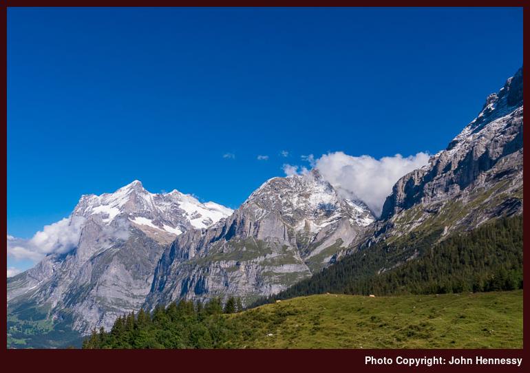
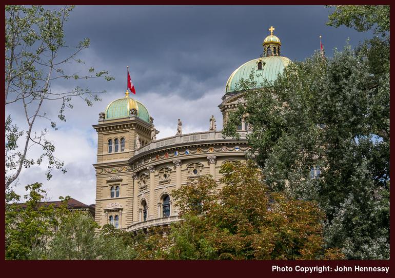
Alpine ambitions also were partially sated with an elongated weekend spent in Switzerland. My base was Geneva, and another morning arrival allowed me to stroll about the place to get my bearings. A trip to Bern followed on the only totally dull day of those that I spent in the country. There were day walks in Alpine surroundings too, with one around Zermatt allowing plentiful views of the Matterhorn under blue skies. That was followed by a journey to Grindelwald that allowed a little taste of how Bern appears in sunshine on the way there. From Grindelwald, I trotted up to Kleine Scheidegg with the Eiger steadfastly remaining cloaked in cloud. Others were on show, so I was not at all disappointed. When the altitude surprised me with its effects after walking at similar heights around Zermatt unperturbed, I was happy with slow progress on the final stretch to Kleine Scheidegg's train station. With clouds overhead and a certain chill in the air, I did not dally, either. After gaining around 1,000 metres in height, I was surprised that my legs were more willing than my lungs, so that is a lesson for the future.
Both of these punctuated a year that has been a journey of spirit following the passage of my father from this life in January. The Icelandic escape slipped me out of a rut into which I had fallen and got me away from concerns about political events in Britain. Solace was a distinguishing feature of the Swiss interlude, and it felt great to stick with enjoying delightful sights in place of life's troubles. That sense of peace has returned from time to time since then, though there has been mental turbulence too. Thankfully, the latter appears to be subsiding while life is running its course.
One downside to both excursions is the cost, and I should have got myself a Swiss Travel Pass for rail travel is expensive there. That means that any future ventures beyond British, Irish or Manx shores will have to await 2016, and I am looking at the possibilities for Norway at the moment. In addition to that, there is more of Switzerland to see with Austria, Germany and France all having their portions of the Alps too. Given what I gained from this year's trips, savouring scenery in other parts of the world is something that I fancy continuing.
Another thing that attenuates foreign travel ambitions after the cost of such exploits, or the passing of the summer, is the need to find my feet again when it comes to Ireland. It no longer feels the same with both my parents gone, and it is as if an anchor has disappeared. There no longer is the feeling of attachment that there once was, even though I still have family there and there are things that need doing on a continual basis. The latter offer a chance to find my place there again, and only time will tell as to how things proceed.
Living in the U.K. for as long as I have has compounded the lack of attachment to Ireland, yet it also has not been a year for walking excursions in the country that I now call home. Around April and May, there were quite of few walks around Macclesfield's hills and August saw me reprise a walk between Monyash and Bakewell via Lathkill Dale. Another factor that may have played its part in keeping me from my usual hill country haunts has been my return to cycling local roads now that I have regained my road confidence. Cheshire has featured strongly in the various routes, and there even was an incursion into Staffordshire that took in Leek and Tittesworth Reservoir. Maybe the shortening days will draw me backing to wandering among hills again.
Beginning a tenth year
It was after the Mayday bank holiday weekend in 2006 that this blog began and, though the actual tenth anniversary is around twelve months away, a lot has happened in those nine years. These have included life changes too, with a change of job (and employer) nearly five years ago subsequently being eclipsed by the loss of my mother over two years ago and my father's taking leave of this world earlier in the year. Life can feel like a roller coaster ride at times.
2013 became all about dealing with the rawness of not having my mother around any more and my father's no longer being there has left me feeling a bit lost when it comes to my ongoing relationship with the country of my birth and upbringing, Ireland. This is something that happens to many people to set down roots away from their homeland, though my father's affairs need management for a while yet, and I still have family on the other side of the Irish Sea.
What perhaps feels a bit stranger is how little an effect this has had on circumstances in the country that I call home. For one thing, where I live most of the time has become more important, and it may look to my work colleagues that little has changed, but the need to find my feet again in a changed life continues. Events like the ones that I have encountered make you think about where you are going in life and there may be a need for a work sabbatical yet if an annual leave allowance is not enough for putting my father's affairs in order.
After my father's funeral, my mind filled with dreams of exploring the likes of the Faroe Islands, Iceland, the Alps or the Pyrenees, but they have been tamed for a while. The initial feeling of release has been tempered by things needing doing in Ireland and having to rest after two years of keeping an eye on a bereaved parent in a nursing home became more of a priority; it is remarkable how something like that can take so much out of you.
Having not had any sort of longer break since January, I was gagging for the Easter weekend because I really needed a bit of "me" time. That the weather came good around was a bonus, though it did little to rouse me to travel away from home. Macclesfield has plenty of local walking opportunities anyway, so I was left short of those. Holy Saturday saw me walk to the recycling centre with electronic equipment for disposal, and I made a longer walk of it by taking in Danes Moss Nature Reserve and a section of the Macclesfield Canal. Easter Sunday allowed a visit to Tegg's Nose Country Park, while Easter Monday saw me walking from Walker Barn to Forest Chapel before I continued to the top of Shutlingsloe. A spot of stravaiging then followed before I settled into returning home via Langley. Tuesday of Easter was another day off from work for me, so I headed to Tatton Park for the afternoon. To complete the set, another trot along the Saddle of Kerridge would be in order, and that has yet to happen this year.
The end of April saw me cross over to Ireland for a spot of sorting, so it was the Mayday bank holiday weekend that was left to allow for further recuperation. Unlike the Easter weekend, this has not been as much of a walking one. The weather has been mixed, and I have been distracted by home computing matters. Aside from putting a computer to rights, I also got to set up a website dedicated to my late father's history writings. He set to trying to use a PC for the first time in his eighties and wanted me to teach him one Christmas after such a busy working year, that it was a break away from such things that I really needed. Disharmony sadly was the result and my mother was left wishing that no one had put the computing idea into his head, especially when his ability to learn was not what it once was, and he was never that technically minded anyway. As it happened, it was my mother who operated video (and DVD) players in their house.
An interest in history is something that I share with my father, so I am happy to put his essays online, albeit with a good amount of editing to prepare them for a wider audience. The whole archive is not online yet, and I am treating it like any website that I have: adding a little over time and tweaking things as I go along. That is how I have done this one and is how I plan to keep things.
Belatedly, I finished off the trip reports for all my walking outings in 2013, so those for 2014 are next on my to-do list. This year has yet to see me embarking on similar escapades, but I am thinking of having a longer summer holiday this year, so that may help. Between this and that, 2009 was the last summer escape that was not an elongated weekend, such as what happened in 2013 and again in 2014. There was a week off in 2011, but I stayed at home then because I more needed the rest before starting out with a new client at work. If 2015 allowed an opportunity like my exploring the Western Isles in 2008, who knows how much writing could appear on here after something like that.
Glenfinnan revisited
This is the last instalment in my report of walks around Glen Coe and Lochaber during a hot weekend in July 2013. My day spent around Beinn a' Chrùlaiste has been recounted already and, on returning to Fort William that evening, I was pondering something easier for the next day. After all, it too was likely to be another hot one and some lower level walking was in order. What came to mind was reprising an out and back stroll along Loch Shiel that I had done under cloudy skies in January 2011. With blue skies and sun, more photos might be had and I headed over to Glenfinnan for some gentler Sunday afternoon strolling.
The train timetable allowed me a chance to attend to some needs in Fort William before I headed off for the afternoon. The train passed some alluring scenery on the way around Loch Eil, and took its time going over the world-famous Glenfinnan viaduct to give passengers a chance to have a look around them. Some may have made photos, though anything taken through a train window can be no substitute for being outside, especially with glare caused by bright sunshine.

On arriving at Glenfinnan train station, I did not hang about though its café was open and started on my way down the A830 towards my rendezvous with Loch Shiel. Folk were filing into the little Catholic church for 13:00 Sunday Mass as I passed, so life for locals was going on as ever. In contrast, my initial destination was the monument at the head of the loch that commemorates the raising of the standard that heralded the start of the Jacobite campaign that ended in defeat at Culloden. This was my first time seeing this in sunshine after the aforementioned winter visit in 2011 and a summertime encounter in 2001 while en route from Portree on the Isle of Skye to Oban, via Fort William and preceding a flying visit to Tobermory on the Isle of Mull.

Leaving that lonesome memorial to an ill-fated act of rebellion that caused the momentary outlawing of Highland culture, I went as if to return to the A830 but took a path shadowing it to reach the track along the southern shore of Loch Shiel. This was something that I found on the previous visit in 2011 and signs were in place showing that it was the work of the Forestry Commission, a then poignant note given the ongoing uncertainty about the future of publicly owned forestry land. Since that time, public protest materialised that made the U.K. government back down, so all is looking brighter than it once did. Not only is there a good path, but the handiwork also includes duck-boarding over soft ground and a bridge over the Callop River too. All this usefully negates the need for a long schlep along the A830 to reach the track leading from Callop to Loch Shiel.

The covering of forestry over the path from the monument to the track may have been sketchy in places but what was there offered some relief from the heat of the day. Increasingly from then on, the tree cover decreased and, soon enough, the oppressive heat was inescapable. Unlike my day around Beinn a’ Chrùlaiste, there was to be no puff of breeze to offer respite and the surrounding greenery along with any body of water looked a little delicate in the strong sunshine. Nevertheless, I made steady progress while relishing what lay about me.

The track down the side of Loch Shiel never is heaving with folk but I got the sense that it was less attractive to active folk than otherwise might have been for I had it to myself for most of the time. On that January visit, parties of cyclists had been out and about, but there were none to be seen this time around. In fact, the only person I remember seeing was a lone jogger and I marvelling at how she coped with the heat. Given that my spirit needed healing after the loss of my mother, solace from solitude was what I needed so I was not complaining at all in the still atmosphere.


For much of the way, I found that rocky topped hills ascended steeply from just beside the track, but things spread out a little around Guesachan where Allt Coire Ghiùbhsachain flowed into Loch Shiel after a short journey or two to three kilometres taking it on a steep descent from just under nearby Sgùrr Ghiùbhsachain and Sgorr Craobh a' Chaorainn. It was the latter that took up more photography time and others doing the same included Meall a' Bhainne, Sgorr nan Cearc and Meall na h-Airigh, all of which faced the right way away from the sun so lens flare could be avoided. The sight of each of these felt worth recording before I continued further along the loch.

Two factors might have me turning around prematurely to head back to Glenfinnan. One was how hot the day felt because the lack of any cooling breeze certainly made walking a little less pleasurable than it otherwise might have been. Then, covering steep untracked ground the preceding day had me wondering what my legs could manage. Even without either of these, I have a tendency for possible overcaution anyway because the return leg can be quicker than the outbound one. Sometimes, it is because height is being lost rather than gained and this was not one of those so it probably was down to seeing the same sights again and being able to leave the camera aside to continue onward.
In retrospect, this would make a good track for off-road cycling and the slightly faster pace would do it no disservice either. Then, I could travel further along before turning around and still enjoy the peaceful ambience. Interestingly, I saw some folk do something like that on my previous January visit so it remains a possibility for the folding bike that I have acquired since then.

After coming back from my stroll by the shore of Loch Shiel, I escaped out of the heat into the National Trust for Scotland visitor centre. Mainly, this was a café visit, but a few souvenirs were acquired in the shop too. After being indoors for a while, I pottered out again and found my way to the top of a hillock behind the visitor centre called Torr a' Choit. From this spot, I suspect that many a photo of Loch Shiel has been taken but such an errand needs to be a morning one and the sun was obstructing any such designs for my afternoon visit so I satisfied myself with photos of scenes around Glen Finnan with its world-famous railway viaduct. Up close, this concrete structure is not such a thing of beauty, but the setting is gorgeous and, when viewed from a distance, it does nothing to diminish its location.


After lingering a good while around Torr a' Choit, I made my way towards the railway station. Now that I recall this, I wonder why I did such a thing as early in the day as I did, for there was quite a while to go before the train was due to arrive. Maybe I thought that my speed of travel was not so speedy after strenuous exertions the day before. While at the train station, I noticed signs for waymarked walks and, with an increased sense of distance, I now chanced following one of these. It took me a little higher, but nothing like the sort of heights that I had scaled on the preceding day. Nevertheless, some of the views took the eye over greater distances with even the distinctive profile of Ben Nevis making an appearance. Mostly, the scenic delights were local to Glen Finnan as I dropped down towards the railway viaduct and made my way back towards the road again to retrace my steps. Temperatures were a little cooler than earlier, so there were others strolling about at lower levels and the sun worked its magic on the surrounding hills and glens.
Back at the train station for the last time of the day, I awaited that train back to Fort William. An easier day had not meant one with less mountain scenery to enjoy and being able to take things more slowly was something to relish too. Life in the preceding months had been a roller coaster ride and there was more to follow. Getting any respite immersed in glorious hill country only was going to help, and my visit has remained in my memory as much to coax a return as to bring a reminder of calm when life goes through one of its rough moments.
Travel arrangements:
Return train journey from Fort William to Glenfinnan.
A day spent around Beinn a’ Chrùlaiste
My first memory of passing through Glen Coe dates from May 1998. It was Scottish Cup Final day and Heart of Midlothian won the match. My mind was on other things and I was making my first-ever trip to Fort William. It was not the sight of Rannoch Moor that stays with but that of seeing mountains emerge from the surrounding near level ground. At the time, it both gobsmacked and mesmerised me with the splendid sunshine falling on these marvels. In all my years in Ireland, I had not come across anything like this sight and I likened up to an upside egg carton. The analogy still remains with me now and my experience was a powerful next step from occasional incursions into Highland Perthshire that exposed me to what lies around Loch Tay. The way that the Tarmachan ridge extends and the shape of Ben Lawers were nothing like their western counterparts. In fact, they were more like MacGillycuddy's Reeks in profile and I had glimpsed those a good few times thanks to my parents' escapades.
For all the wonder of Glen Coe, it is striking that my visits to this part of Scotland have not been as frequent as those to other places. That now seems a travesty when I come to think just how many times that I passed along the A82 that goes right along the glen. Maybe it has been a payback that I did not have so much look whenever walking trips did take me there on foot. The first of these was a trot south from Kinlochleven along the West Highland Way on a day in August 2002 when clouds gradually hijacked the sky. The evening before had been spent in Glen Nevis so I was not offering any complaint.
It amazes me now to think that I played with the idea of going from Kingshouse Hotel to Kinlochleven via Beinn a' Chrùlaiste on a day that was as warm as the one on which I was planning a walk from the head of Glen Coe; this was during July 2013 when a heatwave came our way. However, there was another person who alighted near Kingshouse Hotel who had it in mind to walk from there to Glencoe village. It certainly would make for a lovely walk if it existed, apart perhaps from any hubbub of road traffic along the A82. As things stand, the National Trust for Scotland has been improving things near the aforementioned village so it might be a thought for the future.
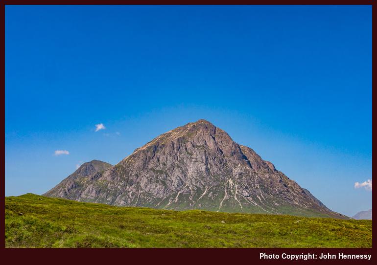
It did not take long for the few of us who got off the coach to disperse and go our separate ways. My choice of route was to ensure that there was plenty of undisturbed peace coming my way for the rest of the day. Some may find the expanse of Scotland's Highlands intimidating but they do offer plenty of spaces where life's hustle and bustle can feel very far away indeed and that is what makes them so special for me. Even on the walk in from the A82 to Kingshouse Hotel did not feel so crowded and this was along a snippet of the West Highland Way too. That left me with plenty of opportunities to stop and take in the views that surrounded me and Buachaille Etiive Mor especially drew my photographic attention even though I had seen it loads of times in other people's photos. Sometimes, there is never any harm in having a memento of your own to have afterwards and everyone gets different weather and lighting too.
Later, I left the West Highland Way after me beyond the hotel, and made my day even quieter than it had been up to then. In fact, it was to be a good few hours spent with hardly a soul going my way and a bit of peace and quiet immersed in glorious scenery was just the tonic for me. First, I went a little along the track towards the Black Corries Lodge before leaving it to follow Allt a' Bhalaich uphill towards Coire Bhalaich. Though the steep south-western slopes of Beinn a' Chrùlaiste would have offered a way up to its summit, I chose to continue towards the bealach between it and nearby Meall Bhalach. Though the day was growing even hotter, there was a cooling breeze that counteracted the growing heat, so my slow steady progress over trackless ground was pleasant enough. Of course, the surrounding views helped too.

There was no let up on the gradient for the last stretch onto the bealach and I ended up a little higher than the 629-metre-high saddle point too. In the clear conditions, this more freestyle approach to navigation was no trouble and it further opened up views over Blackwater Reservoir too. Poring over maps afterwards, I came to the conclusion that I was being granted views of all sorts of hills to the north of me. Even the Grey Corries were within sight and I reckon that both Stob Coire Easain and Stob a' Choire Mheadoin appear above too and these are found beyond Loch Treig! One Mayday bank holiday weekend saw me traipse from Corrour train station to Spean Bridge underneath these and that gives me at least a little sense of how this crumpled landscape fits together.

The distance from the bealach to the top of Beinn a' Chrùlaiste felt longer than I had expected and I now reckon that my less direct approach had added at least a kilometre to my walking distance. As I picked my towards the trig point at the summit, there were plenty of northward views to keep me busy, even if my photographic efforts were bedevilled by heat haze though lens flare could have been a factor too. To see if I could make the results appear more like what I thought I was seeing in reality, I resorted to a Photoshop plugin and the above photo looking over the dam of Blackwater Reservoir has been produced using this. The main bulk of the Grey Corries are to be seen in the far distance with members of the Mamores such as Sgór Eilde Beag and Sgùrr Eilde Mòr to their left.

The additional height around the top of Beinn a' Chrùlaiste allowed me to do better with working out what I had been seeing on previous trots along the West Highland Way between Kinlochleven and Glen Coe. For one thing, the looming rocky dome of Ben Nevis could be picked out as well as the nearby pinnacle of Carn Mòr Dearg to its right in the above photo. With the position of Britain's highest mountain established, you can start picking members of the Mamores like Na Gruaigaichean, An Garbanach, An Gearanach, Stob Coire a' Chàirn, Am Bodach, Sgùrr an Iubhar and others. Even some of these may be tentative, but that, and the prospect of getting images unblemished by blue heat haze, can be another excuse to return to a fabulous part of the world.

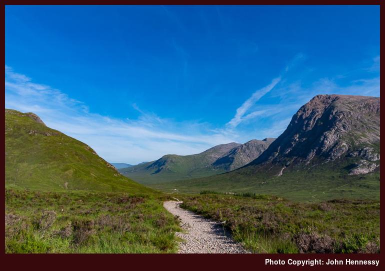
Getting to the top of anywhere is one thing but getting back down again proves that any ascent is only part of the job. This so proved to be the case with Beinn a' Chrùlaiste even though the initial descent was down gentler gradients with additional views of what lay on the other side of Glen Coe. It was now that Buachaille Etive Mor and the Black Mount began to come back into view as I made my way to Stob Beinn a' Chrùlaiste with some boggy stretches still not dessicated by the summer heatwave. Things really got steep, with rough sections underfoot, on the way off Stob Beinn a' Chrùlaiste and I lost any cooling breeze too. Taking things slow and steady was the order of the moment with progress being frustratingly slow at times; nevertheless, it always is better not to become a mountain rescue statistic. As it happens, I have seen one route description for Beinn a' Chrùlaiste that started up the slopes that I was descending, and the author may have had a point in getting these out of the way early for even the descent took a lot out of me and I was glad to be by the side of the A82 again afterwards.
If my designs on getting to Kinlochleven were firm, they could have been behind time after yomping over Beinn a' Chrùlaiste. There still was a long summer evening ahead and I decided to have a go before letting discretion take the greater part of valour and returned to the roadside to catch a coach back to Fort William. The blue heat haze may not have dissipated anyway and I have got a lot from the day, so extending the walk might have been greedy of me. Nevertheless, staying with the route of the West Highland Way on a day as bright as the one that I got would be a delight and cooler temperatures would enhance the experience; it can await another opportunity. Other stunning sections of the trail such as that between Kinlochleven and Fort William or from Bridge of Orchy to the head of Glen Coe remaining tempting reprises too. There may be more hill wandering around here yet.
Transport arrangements:
Return Scottish Citylink coach journey between Fort William and Glen Coe.