Category: Long Distance Trails
More coastal walking on the Gower
Over the past few months, much of what has appeared afresh on here has concentrated on reminisces of Scottish excursions undertaken before this blog existed. It has been a matter of getting something written about these before recollections decay any further than they have. There is more to come but I have decided to take a break to relate a few walking trips from 2014 and these nearly complete every walk of note that I undertook that year.
As I look back on recent years, I notice a recurring trend of revisiting old haunts and much of that happened in 2014 itself. Even the walk featured in this entry was one of those. It was 2012 when I last got to explore the coastline of the Gower and thickening cloud meant that I did not see the coastline between Rhossili and Port-Eynon at its best. What I did see was enough encouragement for a return visit just over two years later when splendid autumnal sunshine was my lot. It was all very different to the advancing threat of thunder and lightning that reached the area in the early hours of a Sunday morning.
2014-09-20
To ensure that I actually got to Gower for a walk that weekend, I travelled on Saturday and spent the night in Swansea. That a few previous attempts foundered because of website troubles and other preoccupations added more motivation to take this course of action. More impetus was added by 2014 being the last year when the Gower would enjoy a summer Sunday bus service. Then, it appeared that such opportunities were not guaranteed to be available again, but there is a summer Sunday and bank holiday service in operation for 2017.
Sticking with the subject of transport, my outbound train was heavily delayed around Shrewsbury too so it was just as well that I was not hoping to make very much of the day. It also meant that I had to attend to some business in Cardiff that I had hoped to do in Swansea so it was dark when I got to my lodgings for the night.
2014-09-21
Unlike the day before which was largely dull and cloudy, the morning of my walk dawned with bright sunshine. Coming late in September, there was a frosty chill in the air as if to remind anyone of the passing of the year. At the same time, the hills lying north of Swansea looked tempting, though you would have to get to the other side of the M4 to reach them. These still are the southern reaches of hilly country leading not only towards the Brecon Beacons National Park but ultimately all the way through Wales as far as its north coast, the very reason why it is so hard to have a railway line running the length of the principality.
None of this did anything to deter me from heading south as planned. As the day warmed, you would be forgiven for thinking that summer was set to last forever and many a day tripper was lured to Mumbles and Rhossili, so buses were busy after what seemingly had been a busy summer for the area.

While the weather was typical of our expectations of summer and Rhossili had plenty of folk about the place, there were signs too of autumn as I pottered about on my way towards Worms Head. Grass was looking tired following the pinnacle of the annual growing season the bracken on Rhossili was changing colour from green to orange as it began to die back ahead of the winter season.

The way towards Worms Head was well frequented and the outcrop looked better than I had seen it on previous visits. The tide was out, so some may have ventured onto its green flanks but the risk of getting marooned by an advancing tide was enough to ensure that I was not one of them. Some do and that is the reason that you find a coastguard station hereabouts.

After all those lingering around Worms Head, things grew quieter. Groups of young people came against me as I rounded Fall Bay and I was led to wonder if this has become part of the Duke of Edinburgh Award now that Wales Coast Path is very much in existence. Others strolled the way too since they were taking in circular walks around Rhossili. After passing the last public footpath leading to nearby Middleton, these too petered out in their turn.
The best part of any walk for me is when I largely had my surroundings to myself and that is how it largely felt as I walked from Mewslade Bay to Overton Cliffs. Progress was good too, though I slightly chide myself for going so well on what was a gorgeous day. In my defence, I was passing through a lot of pasture and the distance may not have been that long. It was not all about having improved fitness because of indoor bike training.

For all their proximity to human habitation, Overton Cliffs look fabulously isolated and few passed the way. Under cloudy skies, their allure was not lost, but added sunshine worked some magic. It helped that I was not anxious about catching a bus this time around so I had space to enjoy what lay around me. Port-Eynon looked further away than it was.

After passing these delights, there was one final ascent to test me before I dropped down to Port-Eynon's beach to battle the soft dry sand to reach tarmac again. Before all that, I was to pass the Gower Society monument with the bell of a sea buoy beyond Port-Eynon Point ringing in my ears, a reminder of the stillness that I met on my previous visit. There was a little time to linger at the final destination for my hike before an on time bus returned me to Swansea from where I began the train journey home.
It had been a satisfactory weekend away and I am now pondering other possibilities. Even the more madcap idea of walking from Port-Eynon to Mumbles via Oxwich and Threecliff Bay has entered my mind. There are ways of shortening this to make the escapade more sensible if needed. Then, there also is the Gower Way to consider so it is not as if there is not more to see around here. There are further rewards for repeat visitors.
Travel Arrangements
Return train journey from Macclesfield to Swansea. Travel by bus from Swansea to Rhossili and from Port-Eynon to Swansea.
An irritating week around Argyll and Lochaber
Sometimes, my trips to Scotland do not work out how I want them to do. Even with all the watching of the progress of the jet stream, that was how it was in 2003. Unlike 2002, I brought my week in Scotland forward from the end of August to the end of July. It would have been a week earlier but I did not want to clash with someone else's holiday plans. Putting your work first can have its drawbacks.
In hindsight, waiting an extra week would have been the better outcome because I returned home with sights of sunshine on Lakeland Fells. Further visits to Cumbria in an effort to dispel any irritation but it took a Summer Bank Holiday weekend around Fort William to truly put my poor run of luck behind me.
My journey from home to Oban still was made in hope and it took me around by Edinburgh where I spent a little while before continuing on my way. The cause was my inability to catch an onward connection in Glasgow because of the late running of an earlier train.
The following day came dull and eventually turned to rain but I fitted in a walk from Oban to Taynuilt by way of Glen Lonan before the dampness arrived. My lot was road walking but it still got me out into Scottish countryside so it was a good start. The wet evening allowed for some shopping around Oban and maybe some thoughts of what I would do next.
For what turned out to be the best day of the week, I returned to Taynuilt for an out an back walk along the shores of Loch Etive. Unlike the previous November's stroll with mates from Edinburgh, I was set to continue beyond Glen Noe to reach the foot of Glen Kinglass and go a little further along before starting to retrace my steps again. The day was sunny so I was making photos with what I thought to be a full complement of colour camera film. What I later found is that not all the allocation came with me so I was left with a shortage during the best time of the day. In spite of this irritation, it is the utter peace of my turning point that stays with me as much as the sights that I saw. There have been further return visits since then with August 2014 being the most recent one. That photographic oversight has been well overshadowed since then and the lesson has not been forgotten.
What I did next now sounds a bit foolish given what I knew about the need for northward movement of the jet stream. Instead of finding somewhere else to be around Argyll, I continued north to Lochaber for what turned out to be a series of soakings. Any efforts to make contact with a friend in Edinburgh regarding alternative arrangements proved fruitless so I stayed a few nights in Banavie instead. Being a few miles away from Fort William meant that the any poor fortune with a spell of wet weather resulted in my needing to dry out afterwards. You hardly can have enough clothes with you when this happens repeatedly.
Still, the rain cleared enough on my arrival in Lochaber to allow me to head into Glen Nevis to find the path leading to Cow Hill that became the basis for a longer walk. Friday was drier if devoid of sunshine yet I returned to Kinlochleven for another taste of the West Highland Way. This time, my course took me north through Lairig Mor to Glen Nevis. Even without a sunny day, the scenery was stunning and seeing it again became an excuse for my return around a month later. Though the trail is a popular one and the location is among its high points, this was a quiet day to be sampling it with hardly a soul passing the way. That might have had something to do with the weather of that week.
Saturday saw me head into Glen Nevis again. This time, I caught the bus to get me there faster and I pottered in beyond the car park. My lot was boggy ground and heavy rain showers but the surroundings would have looked stunning in better weather. Constant hope continued to drive me in spite of my poor fortune so any glimmer of sunshine on the way back to Fort William was enough to see me reach for my camera.
Thinking about this disappointing episode now makes me realise that my attentions veered elsewhere and that some of these spots need revisiting. A walk taking in Cow Hill in pleasant weather would complement one going deeper into Glen Nevis than I ever have gone before. Maybe I should not be devoid of inspiration for future explorations on a longer stay in Fort William after all. Other possibilities come to mind but I will restrain myself here in case I repeat those described elsewhere.
Travel Arrangements
Train travel from Macclesfield to Oban, from Taynuilt to Oban and from Fort William to Macclesfield. Coach service 918 from Oban to Fort William. Bus service 44 from Fort William to Kinlochleven.
A day spent around Beinn a’ Chrùlaiste
My first memory of passing through Glen Coe dates from May 1998. It was Scottish Cup Final day and Heart of Midlothian won the match. My mind was on other things and I was making my first-ever trip to Fort William. It was not the sight of Rannoch Moor that stays with but that of seeing mountains emerge from the surrounding near level ground. At the time, it both gobsmacked and mesmerised me with the splendid sunshine falling on these marvels. In all my years in Ireland, I had not come across anything like this sight and I likened up to an upside egg carton. The analogy still remains with me now and my experience was a powerful next step from occasional incursions into Highland Perthshire that exposed me to what lies around Loch Tay. The way that the Tarmachan ridge extends and the shape of Ben Lawers were nothing like their western counterparts. In fact, they were more like MacGillycuddy's Reeks in profile and I had glimpsed those a good few times thanks to my parents' escapades.
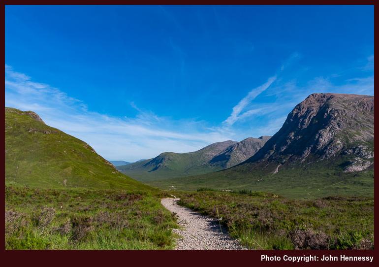
For all the wonder of Glen Coe, it is striking that my visits to this part of Scotland have not been as frequent as those to other places. That now seems a travesty when I come to think just how many times that I passed along the A82 that goes right along the glen. Maybe it has been a payback that I did not have so much look whenever walking trips did take me there on foot. The first of these was a trot south from Kinlochleven along the West Highland Way on a day in August 2002 when clouds gradually hijacked the sky. The evening before had been spent in Glen Nevis so I was not offering any complaint.
It amazes me now to think that I played with the idea of going from Kingshouse Hotel to Kinlochleven via Beinn a' Chrùlaiste on a day that was as warm as the one on which I was planning a walk from the head of Glen Coe; this was during July 2013 when a heatwave came our way. However, there was another person who alighted near Kingshouse Hotel who had it in mind to walk from there to Glencoe village. It certainly would make for a lovely walk if it existed, apart perhaps from any hubbub of road traffic along the A82. As things stand, the National Trust for Scotland has been improving things near the aforementioned village so it might be a thought for the future.
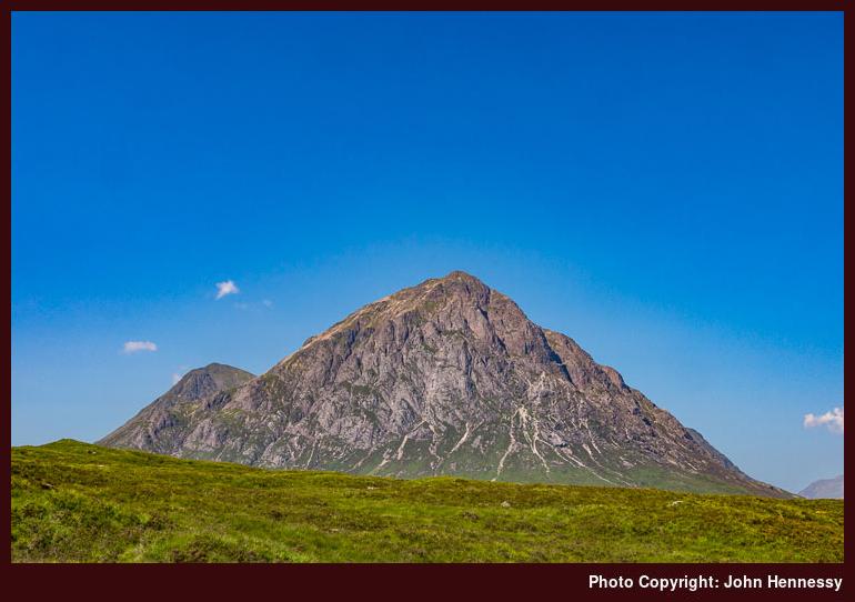
It did not take long for the few of us who got off the coach to disperse and go our separate ways. My choice of route was to ensure that there was plenty of undisturbed peace coming my way for the rest of the day. Some may find the expanse of Scotland's Highlands intimidating but they do offer plenty of spaces where life's hustle and bustle can feel very far away indeed and that is what makes them so special for me. Even on the walk in from the A82 to Kingshouse Hotel did not feel so crowded and this was along a snippet of the West Highland Way too. That left me with plenty of opportunities to stop and take in the views that surrounded me and Buachaille Etiive Mor especially drew my photographic attention even though I had seen it loads of times in other people's photos. Sometimes, there is never any harm in having a memento of your own to have afterwards and everyone gets different weather and lighting too.
Later, I left the West Highland Way after me beyond the hotel, and made my day even quieter than it had been up to then. In fact, it was to be a good few hours spent with hardly a soul going my way and a bit of peace and quiet immersed in glorious scenery was just the tonic for me. First, I went a little along the track towards the Black Corries Lodge before leaving it to follow Allt a' Bhalaich uphill towards Coire Bhalaich. Though the steep south-western slopes of Beinn a' Chrùlaiste would have offered a way up to its summit, I chose to continue towards the bealach between it and nearby Meall Bhalach. Though the day was growing even hotter, there was a cooling breeze that counteracted the growing heat, so my slow steady progress over trackless ground was pleasant enough. Of course, the surrounding views helped too.

There was no let up on the gradient for the last stretch onto the bealach and I ended up a little higher than the 629-metre-high saddle point too. In the clear conditions, this more freestyle approach to navigation was no trouble and it further opened up views over Blackwater Reservoir too. Poring over maps afterwards, I came to the conclusion that I was being granted views of all sorts of hills to the north of me. Even the Grey Corries were within sight and I reckon that both Stob Coire Easain and Stob a' Choire Mheadoin appear above too and these are found beyond Loch Treig! One Mayday bank holiday weekend saw me traipse from Corrour train station to Spean Bridge underneath these and that gives me at least a little sense of how this crumpled landscape fits together.

The distance from the bealach to the top of Beinn a' Chrùlaiste felt longer than I had expected and I now reckon that my less direct approach had added at least a kilometre to my walking distance. As I picked my towards the trig point at the summit, there were plenty of northward views to keep me busy, even if my photographic efforts were bedevilled by heat haze though lens flare could have been a factor too. To see if I could make the results appear more like what I thought I was seeing in reality, I resorted to a Photoshop plugin and the above photo looking over the dam of Blackwater Reservoir has been produced using this. The main bulk of the Grey Corries are to be seen in the far distance with members of the Mamores such as Sgór Eilde Beag and Sgùrr Eilde Mòr to their left.

The additional height around the top of Beinn a' Chrùlaiste allowed me to do better with working out what I had been seeing on previous trots along the West Highland Way between Kinlochleven and Glen Coe. For one thing, the looming rocky dome of Ben Nevis could be picked out as well as the nearby pinnacle of Carn Mòr Dearg to its right in the above photo. With the position of Britain's highest mountain established, you can start picking members of the Mamores like Na Gruaigaichean, An Garbanach, An Gearanach, Stob Coire a' Chàirn, Am Bodach, Sgùrr an Iubhar and others. Even some of these may be tentative, but that, and the prospect of getting images unblemished by blue heat haze, can be another excuse to return to a fabulous part of the world.

Getting to the top of anywhere is one thing but getting back down again proves that any ascent is only part of the job. This so proved to be the case with Beinn a' Chrùlaiste even though the initial descent was down gentler gradients with additional views of what lay on the other side of Glen Coe. It was now that Buachaille Etive Mor and the Black Mount began to come back into view as I made my way to Stob Beinn a' Chrùlaiste with some boggy stretches still not dessicated by the summer heatwave. Things really got steep, with rough sections underfoot, on the way off Stob Beinn a' Chrùlaiste and I lost any cooling breeze too. Taking things slow and steady was the order of the moment with progress being frustratingly slow at times; nevertheless, it always is better not to become a mountain rescue statistic. As it happens, I have seen one route description for Beinn a' Chrùlaiste that started up the slopes that I was descending, and the author may have had a point in getting these out of the way early for even the descent took a lot out of me and I was glad to be by the side of the A82 again afterwards.
If my designs on getting to Kinlochleven were firm, they could have been behind time after yomping over Beinn a' Chrùlaiste. There still was a long summer evening ahead and I decided to have a go before letting discretion take the greater part of valour and returned to the roadside to catch a coach back to Fort William. The blue heat haze may not have dissipated anyway and I have got a lot from the day, so extending the walk might have been greedy of me. Nevertheless, staying with the route of the West Highland Way on a day as bright as the one that I got would be a delight and cooler temperatures would enhance the experience; it can await another opportunity. Other stunning sections of the trail such as that between Kinlochleven and Fort William or from Bridge of Orchy to the head of Glen Coe remaining tempting reprises too. There may be more hill wandering around here yet.
Transport arrangements:
Return Scottish Citylink coach journey between Fort William and Glen Coe.
Hot weather escapades with views of Ben Nevis
Some may adore sunshine holidays in destinations where scorching temperatures are commonplace, but that is not my preference. Childhood memories of the summers of 1983 and 1984 feature sweaty journeys across fields on afternoons with sweltering temperatures and this was Ireland's south-western corner. Strangely, the higher temperatures of around 30° C experienced around Saint Malo on a school trip in 1989 have no such associations in my memory and I am left to wonder if the coastal location with its sea breezes had anything to do with it. Nevertheless, it is those sultry inland days that have convinced me earlier that cooler days were more to be my liking.
In spite of that thinking, there are times when the desire to go for a walk in summer sunshine gets the better of me; there was a time when a heatwave was a time when I scotched the idea of embarking on a walking excursion. Much of the time, this has me out in temperatures hovering around 20° C, but there are times when those in excess of this are overlooked. The trouble with physical activity on warm days is that staying well hydrated becomes more of a concern. It is all too easy to let yourself go to the point that headaches and other symptoms start to strike so you never can be too careful.
The summers of 2013 and 2014 brought a good share of warm sunny weather to Britain after winters that were either long and cold (2013) or wet and stormy (2014). In some ways, they were not so unlike those from thirty years earlier. Even so, I so needed a getaway after the events of springtime 2013 that I booked in an extended weekend during July that I used to head to Fort William. It was one of those "come what may" bookings and it was hot sunny weather that I got.

Travel days were Friday and Monday, so Saturday and Sunday were available for spots of exploration. Friday was so hot that train and coach air conditioning could not be but relished. The stifling heat around Glasgow was all the more unmissable as I trotted from Glasgow Central train station to Glasgow Buchanan bus station and Fort William felt similar. Things must have a cooled a little as I wandered out on an after dinner stroll before retiring to bed for the night.

With that in mind, I am not surprised that I went for light strolling around Glenfinnan on the Sunday. Then, I walked a little of the shore of Loch Shiel to reprise a walk that I had done of a Saturday in January 2011. Skies were clearer the second time around and enjoyed the views before taking a break from the sun in the café at the National Trust for Scotland visitor centre. After that, I went up the small hill behind it and lingered to take in what I could see from the vantage point. That was not all, since I stumbled on a walk that dropped from Glenfinnan's train station down under the scenic railway viaduct that features in many photos and in the Harry Potter films too. Temperatures must have cooled because I only have pleasant memories of these and others were out savouring the surroundings too.


It was the preceding Saturday that saw me being more adventurous. It is something that I ponder with amazement now but the idea of walking from Kingshouse Hotel to Kinlochleven with a diversion to the top of Beinn a' Chrùlaiste somehow trumped what now looks like my better reason. Thankfully, there was a cooling breeze assisting the ascent and views opened up all around me. What also became apparent was the amount of heat haze that abounded on more distant hills. The Mamores and the White Corries were most affected and I have been experimenting with the Neutralhazer plugin in Photoshop to see what it can do for me. Of course, a day with less challenging lighting would be better and Beinn a' Chrùlaiste is such a place that a return is worthwhile.

On the day, the hill forestalled my plans to go all the way to Kinlochleven. That is not to say that I did not try myself out before going the way of reason. Now that I think of it, the lost golden evening may not have got me much more than I had anyway. The day had been a good one and looking over things now opens up more possible escapades like walking from Rannoch train station to Kingshouse Hotel or even an out and back hike from Glencoe village to the top of Meall Ligiche. The more modest height of the latter could afford some stirring views of higher eminences too, so the TGO route idea could be a goer. Repeating sections of the West Highland Way north of Bridge of Orchy also tempts me, so Glen Coe may not be see me deserting the place just yet when there is so much more to see.
What I have not done either is say all that I can do about those walks for what was intended to be a single entry has turned into a three part series. Next up is the piece on Beinn a' Chrùlaiste with that on Glenfinnan set to follow that. Hopefully, those should not be the last you hear of my exploring these areas. After all, there is much left to savour since I barely have scratched the surface and that is after numerous visits over the years.
Travel arrangements:
Return train journey from Macclesfield to Glasgow and return Scottish Citylink coach journey between there and Fort William. Return Scottish Citylink coach journey between Fort William and Glen Coe. Return train journey between Fort William and Glenfinnan.
Encountering ravishing surroundings while wounded inside
It can be amazing how resilient the human spirit can be. After all that came my way in 2013, I am amazed at how I manage to find to some inner peace as much of the time as I do. That wasn't how it felt in April after my mother passed away the month before. Then, looking ahead didn't seem a possibility. Getting somewhat accustomed to the changed state of affairs was more than enough to slow down life itself.
In the midst of that, I took to walking every evening because that's how time can be set aside for working through things and venting any stress through footsteps so as not to hurt others. During one of these walks, I decided that a longer walk was in order and quieter hill country would be most suitable. When glorious weather came for the first Saturday in April 2013, I had my chance and it was taken without hesitation. Staying indoors dwelling just wasn't an option with the rawness that was within me. It was the hill country to the east of Hayfield and Glossop that drew me. It may attract its share of visitors, but that never means that there aren't quieter spots and quiet interludes on well frequented patches. Such was what I needed and there were plenty on the day, especially in its later hours. Those restorative moments were relished when they came.
My initial plan was to make for the track up to Edale Cross and use that for getting up to Kinder Scout after a diversion to see Kinder Reservoir from where I knew there were photos to be had, especially in bright sunshine. Once off Kinder Scout, it was to be a matter of dropping down to Glossop on the Doctor's Gate Path. However, I changed my mind during the walk, as can happen. On finding the descent to see Kinder Scout to involve the loss of more height than expected, I instead chose to go around by the dam of the reservoir and regain height on the way up to and through William Clough. Other than that, the walk was routed as intended and I have left the possibility of going along the western edge of Kinder Scout for later. On looking at its northern slopes and streaked they were with snow, it looked to have been a sensible choice.
All of this chopping and changing route lay in the future as I left Hayfield by way of the Pennine Bridleway, a multi-modal track that starts in the Derbyshire Dales and then goes north at least as far as Settle. One section is called after the off-road horse riding access campaigner Mary Townley and the whole trail also is open to moderately adventurous off-road cyclists too. Apart from Derbyshire, I also have met with it around Burnley when I used it on Pennine Way jaunts between Haworth and there.

Though the Pennine Bridleway would have carried me near Coldwell Clough and the bridleway for Edale Cross, I left it for a path for Bowden Bridge instead. That kept me alongside the River Sett for longer and past the illustrious quarry where the gathering prior to the Kinder Trespass of 1932. Looking up for some photos, my gaze revealed the location of the said plaque and I made of photo of it for a sort of keepsake.

After largely staying on the level for the start of the walk, it was time to gain some height and there was plenty of that on the track from Bowden Bridge towards Coldwell Clough. Folk were trailing in my wake so I wasn't doing this by myself but the turn away from the track leading to Ashes Farm meant that I lost them; they probably were bound for elsewhere or turned back after gaining their fill. Whatever they did, I hope what they got from their outings was memorable.

Beyond Coldwell Clough, the track to Edale was obscured by a deep white covering of snow. As I was getting to that point, a silent gentleman in a Land Rover had driven up (to my mind, he appeared to be an estate worker and there was little or no acknowledgement of any pleasantries were sent his way) and was stopped there for a while. Off-road cyclists were about too and I am unsure as to why the man in the Land Rover was waiting. As I scaled the snow-buried track, he left for somewhere else so I was wondering if was being watched for some reason, hopefully benevolent.
Beyond the snow patch, I largely had the Edale track to myself and took to looking around me. There were hills to the south of me, and these were blocking any view of the New Mills to Sheffield railway line though that enters a tunnel too to get from Chinley to Edale. Looking at the map now, hills like South Head and others near are tempting and caught my eye on visits made to Sheffield by train earlier in the year. They, like other parts, are awaiting their turn for a visit.

Kinderlow End lay right in front of me now and I was seeking the path that would get to views of Kinder Reservoir that I had not seen for the most of ten years. Those were under overcast skies and I quite fancied seeing them in prettier weather. Before then though, there was time for a spot of lunch and I needed to contend with a gate that was forced shut by a bank of snow. On finding how much I was losing to get to the sights that lay in my memory, I started to change my mind about the course that I had planned. Though it often is a wrench to do so, there are times when you can take on too much, so your cloth has to be cut from your allowance. This was one of those and I dropped down towards the Kinder Dam, crossed below it and started to gain height on the other side.

Kinder Reservoir is one of those operated by a water company and once had its own purification facility. This is now shut with the required processing going on elsewhere and broken skylights on what otherwise looks like an impressive building are signs of its redundancy; hopefully, its fate doesn't mean utter dereliction. Leaving the former purification plant after, I continued along White Brow and Nab Brow to retrace a route followed under overcast January skies in an era before this blog started. Recollection of the actual year is vague now but 2003 feels about right. Retracing of steps got sights from that earlier occasion on a more flattering and so were worth any toil. Below me lay permissive paths that encircle the reservoir and it was to pain me a little to have to lose height to go near their level to cross a stream before heading up William Clough.

William Clough never was seen by me in better conditions and I revelled in the sights that lay ahead of though the path was uncertain at times. In fact, I was unsure whether I was following an intended right of way or taking advantage of a permissive path. Either way, I negotiated my way uphill steadily and negotiation was the appropriate term when I encountered a bank of snow covering the path near the top of the clough. Once past that, I didn't have far to go before the gradients eased again. Some folk were asking me about the way down and a National Park ranger passed the way and they went with him so I assume all was well for them from that point forward.

Once above William Clough, I found that clouds had filled the sky and it looked as if hope for sunlit scenes was extinguished for the day. Hence, any photos of the northern elevation of Kinder Scout were made with a sense of making the best of what was given to me. Looking at the photo above, it is tempting to think that I wasn't being dealt cruelty either. Seeing the patches of snow made me not envy anyone following the Pennine Way north off Kinder Scout, though the possibility of following a path via Black Ashop on another day entered my head.

Unlike previous occasions, the flagged path of the Pennine Way felt long as I headed towards the A57. The route taken hardly is a direct one anyone with its liking for going east. There was one good development overhead me though in that clouds were dissolving overhead me. That was set to grant me a pleasing evening filled with the challenge of following the Doctor's Gate Path back to Glossop after crossing the aforementioned trunk road between Glossop and Sheffield.
There was a hint of what was to come in the form of a snow bank that completely engulfed what should have looked a tame gate appropriate to more domesticated terrain. With a steep incline ahead of me, I needed to gather my wits to overcome this obstacle and there were deviations from the intended right of way to deal with more ill-located snow banks and subsidence that had affected even stretches of path that weren't snow-covered. It certainly isn't easy terrain for off-road cycling or horse riding, so the bridleway designation mystifies me.


Nevertheless, the Doctor's Gate Path does grow more tame as you come nearer to Glossop. In fact, I see the footbridge crossing Shelf Brook as the dividing line between wilder and tamer countryside. There is a path beyond there that takes you higher up the hillside so that muddy brookside hopping can be avoided. With some time to hand, it was around here for another I took another refuelling stop and sampled the peace of my surroundings. It was balm for my torn insides so I relished the moments that I had.
From then on, the walking was easier and the path turned into a track around Mossy Lea Farm and I started to encounter folk out for a quick late evening stroll before the light finally died. My guess is that they were sticking to the good track and were far from intent on seeking adventure. A minuscule slice of that had come my way, though it was the quieter moments that I really relished when my spirit needed them. That excuses for other walks appeared in the form of that intended route along the western edge of Kinder Scout or a possible paved path that leads by Whitethorn Clough that could become a more direct route option for hiking to Glossop from Kinder Scout. It was if some things from a previous life remained for what felt like a very new one.
Travel Arrangements:
Bus service 58 to Buxton and bus service 61 from there to Hayfield. From Glossop, I went home by train with a change in Manchester Piccadilly.