Category: Long Distance Trails
Revisiting Calderdale after a long absence
2007 became a year that was dominated by walking sections of long-distance trails like the Pennine Way. That in turn led me to Calderdale during the spring of that year. Two trips stand out for me with the first being near the start of February and the second near the start of March. Since those, I hardly have explored the area with other places gaining my attention.
This is a part of the world laden with so many public rights of way that it is difficult to pick out a few to facilitate some wandering. Maybe it is better to ramble from one to another in a more haphazard way and civilisation is ever at hand in the valley below the moors in any case. That sort of approach lay in the background as I plied my circuitous way from Hebden Bridge to Todmorden during the autumn of 2017.
It was a sunny if chilly Friday so it was little surprise to see others wandering about as well. Even so, I was about to find plenty of those quieter interludes that I relish so much. The advantage of having many paths to follow is that people can spread out everywhere. Some of these rights of way were not as clear or as well signed as others, but there was no conflict with landowners either.

There may have been a problem with train services going east from Hebden Bridge but it did little to delay my arrival and was soon forgotten as I scaled the steep slopes to reach the moors in the autumn sunshine. Because of all the path options, that also meant correcting a wrong turning and I got to wondering if having a GPS receiver with me might have been better. These days, the OS app on my phone would have been enough to put me right but that lay in the future back then.

The constant sunshine and the multitude of quieter places meant that I could navigate from right of way to right of way in peace and with ample time for ensuring that I was going in the right direction. Some of these followed clear tracks while others took me straight across boggy ground. Along the way, I took in views towards Heptonstall and Mytholmroyd though any sights of Hebden Bridge were lost in the steep-sided cleft of Calderdale. On any hike, some views are left behind you as you proceed towards others.

My eventual destination was Stoodley Pike and getting there meant passage along part of the Pennine Way, so the direction of travel was easy to follow at this point even if the air was chilly enough for me not to tarry for too long. Cloud may have started to fill the sky, but any disruption of sunshine was momentary so I started on my way towards Todmorden. That took me down a steep incline using part of the Calderdale Way to Mankinholes and Lumbutts from where a mixture of road walking and footpath rambling got me to my final destination in ample time for the train journey home again after what had been a satisfying stroll with an added element of problem-solving.
Travel Arrangements
Train journey from Macclesfield to Hebden Bridge followed by a train journey from Todmorden to Macclesfield.
A busy spring
The continuing non-availability of Northern train services on Saturdays due to industrial action became such a source of personal confinement that their restoration produced such a dramatic effect. From February until now, I have been away most weekends, making use of the increased opportunities for train travel. The promising weather helped too, even if it meant that water supplies were not getting replenished as required after last summer's extended spell of hot and dry weather.
The result was that Yorkshire got a lot of attention throughout February and March. It started with a visit to the North York Moors on a sunny day in February that felt more like summer than the actual time of year. Roseberry Topping was revisited, as well as nearby hills, as I traced out part of the Cleveland Way on a circuit centred on Great Ayton's Train station.
Other circuits were followed by train as dictated by the extent of day ranger ticket areas. Two of these took me between Leeds and Carlisle, so it might have been inevitable that I ended up getting ideas for walking outings as a result. The departure point for such attentions was Settle, since I had not passed Attermire Scar or visited Malham and its nearby tarn for far too long. Sunshine may not have been in ample supply through my walking rounds, so another trip to Malham Cove cannot be ruled out, and it could see me going to Skipton on foot as well. There were two outings in total, and there already is another in mind.
It has been a spring full of city visitations, too. In the north of England, the tally included Newcastle, Leeds and Sheffield and Scottish cities like Edinburgh and Stirling got their share of attention too and there even was a trip to Cardiff for some wandering by the River Taff. More will be written about these below, while Newcastle saw more wandering than other northern cities as I pottered along by the River Tyne on the way to Wallend using part of Hadrian's Wall Path. That again was a quieter stroll, and there was much to savour on a journey from a city centre to greener parts of its suburbs.
An elongated Easter weekend allowed for a longer stay in Edinburgh that has been in mind for some time, and there was a truncated effort in 2017. 2019 saw no such intrusions, so I was there from Holy Thursday through to Easter Tuesday as planned. That allowed for a lot of city rambling, and there were two visits to Linlithgow. Hill wandering featured too, and days were spent among the Pentland Hills and doing a round of the hills encircling Glen Sax. Along came reminisces and silly daydreams entered my mind, but the time spent around a city where I spent part of my university years also became a chance to deal with any episodes of unfulfilled promise that returned to haunt me.
When I moved away from Edinburgh in 2000, there may have been an element of unfinished business that drew me back again and again to somewhere for which I still hold much affection. The 2019 version of the same was a suboptimally composed photo on Calton Hill, so I returned on the Mayday bank holiday weekend to set that to rights. Other sights like the city's botanic gardens and Corstorphine Hill Local Nature Reserve were frequented too, and the latter featured on another visit during the following weekend.
Though I was bound for Stirling, a stopover in Edinburgh did allow me to revisit The Royal Mile and Corstorphine Hill in good sunshine for the sake of a little closure of what was becoming like an Edinburgh trilogy. Stirling saw plenty of sauntering with photographic pursuits in mind, but the prospect of a walk among the nearby Ochil Hills remains outstanding, so that could be another excuse to go back up there again.
After all those weekend forays elsewhere, it now feels as if some quiet time at home is in order, and that pervaded the Spring Bank Holiday weekend aside from the aforementioned day trip to Cardiff. Others making the same journey had the attendance of a Spice Girls concert in mind, but designs were far more demure as I avoided bands of cyclists to amble by the River Taff to take in the spring foliage on trees around Bute Park and Llandaff on a sunny afternoon that could not be enjoyed further north, such was the available weather. The summer awaits, so only when that arrives will its roaming be revealed.
Rewards for a reluctant departure
It took until July 2009 for me to make my first visit to the Isle of Man, and that was a rain-drenched day trip. May 2010 saw me spend a bank holiday weekend on the island when I took in sections of its coastal walk, Raad ny Foillan or the Way of the Gull. That also was the pervading theme for a subsequent trip in July 2011. Since then, though, I ended up leaving the island alone until April 2017 when I was lured there early in a springtime sabbatical from work. It is that which I am recalling here.
Departure
The first week of my sabbatical was somewhat relished as I spent it on sorting out Irish affairs together with a series of computer upgrades. It was during this that I plotted a Manx revisitation. As I approached the weekend, a certain reduction in enthusiasm came upon me, and I opted for a Friday evening sailing once I cleared my arrival time with my hotel. That was just as well, given that more Irish business emerged before I departed for Liverpool.
Once in Liverpool, there was a dash on foot from Lime Street train station to Albert Dock in around twenty minutes. As I did so, I passed those in the city for the weekend of the Grand National horse race at Aintree. Others intending to travel on the day itself would have to contend with train staff being on strike.

Having got on the boat on time, I enjoyed the evening light as the ship plied the Mersey on its way from Liverpool with only my luggage as an encumbrance; in hindsight, I should have checked in some of it into the hold, a lesson that I learned for the return sailing. Everything looked enhanced, so it almost took the fall of darkness itself to get me inside to get some food in advance of arriving in Douglas. Once there, it was a direct walk to my lodgings for the weekend, made without further ado.
An Improving Day
It must not have taken much to organise myself, for I was in Laxey soon enough after getting there by bus. Some food was acquired in advance of my hike and I took the chance of pottering as far as the local train station, served by electric trams from Ramsey, Douglas and the top of Snaefell itself. Any temptation posed by a ride top the top of my objective was dispelled, and I set off there on foot.
My course took me along Glen Mooar towards Agneash with Laxey Wheel to be seen across the valley. The skies were laden with clouds at this point, so one might have wondered at my resolve. From Agneash, I went east for a while to pick up a track that would take me past such hilltops as Slieau Ruy, Slieau Ouyr and Slieau Lhean.

Those tops were partly obscured by low cloud, but this started to break up as I continued west until there scarcely was any trace of it at all. The only photographic problem then was the flat light that can be got on a day early in April, and haze that seemed as if coming from drying out hills. Even so, my surroundings continued to delight me, and that was to endure for the rest of the day.

Passing Cragh Ouyr, dropped me down to the A18. The track disintegrated on the ever more boggy terrain, but you can expect such things on a springtime stroll like the one that I was undertaking. A rest stop was taken by the roadside before I took advantage of ramblage rights (think right to roam, Manx style) to make a direct ascent of Snaefell's steep north-eastern slopes.

Nearer the top, the gradients relented, and I was to potter about a flat-topped summit littered with two masts, a train station and a restaurant. The bitter breeze was not so welcoming, yet any temptation posed by the restaurant was resisted, and I began my way down with views over Sulby Reservoir and other such sights. The Manx island top had been visited.

My descent returned me to the A18 and the road was quiet, so I walked along it in preference to the nearby ramblage or open access land because of tiring limbs. Apparently, the lack of traffic was caused by a road closure for repairs, as an enquiry from a passing cyclist demonstrated to me.
At Windy Corner, I left the A18 to take the track down to Glen Roy, with Slieau Lhoist to the immediate south of me. My recollections of the track have stretched it beyond what appears on a map, but I arrived at a narrow lane being used by some motorised traffic. Nevertheless, I headed north along the road to brave up and down crossings of various streams before I was being led east again. A path through Axnfell Plantation was rejected in favour of the more direct way to Laxey that I was following.

Having overlooked it earlier in the day, I decided to pay a visit to the iconic Laxey Wheel. This old mine water pump looked better in the evening sunshine than in the morning dullness, so I tarried a while before returning to Laxey for some food and the bus back to Douglas.
Better than Predicted
The forecast suggested otherwise, but Sunday brought some decent weather before rain finally arrived in the evening. By then, I was back in Douglas, so it was far from being an irritation. After the previous day's exertions, some lighter activity was in order and matters were needing attention before I headed off for an excursion in any case. This was not going to be a day that brought disappointment.

Inspired by it being cloudy by the time that I reached the place on a walk from Port Erin in July 2011, I decided that a longer visit to Castletown was in order. Handily, it remained sunny for much of the time that I was, so some photography was allowed before the arrival of cloudier skies put a stop to such endeavours. Thus, I made up for any shortfall from my previous encounter with the place.

Having pottered about Castletown while making some photos of what was there, I decided to go further afield and retraced more of my steps from July 2011. Though without a map because of low expectations, my memory more than compensated, and useful footpath signs filled in any gaps as I wandered along a circuit that took in Scarlett Point with views of Castletown Bay and Bay ny Carrickey to be savoured in addition to those of the coastline along which I passed.
On arriving back in Castleton, I was tempted to see the inside of the castle at its heart before returning to Douglas. If I recall correctly, this was late in the working day for Manx Heritage, but I go my fill before returning to Douglas for the evening. The arrival of rain did not intrude for I was indoors by then, and it passed quickly enough for a saunter alongside Douglas Bay until I came to the end of the promenade near Onchan. There, I retraced my steps and saw no sign of the Mormon missionaries that I had passed on the outbound stretch of my stroll. On reaching my hotel, I retired for one more night on the Isle of Man.
Some More Strolling
July 2011 had not finished with inspiring me, and there was time for more exploration before my afternoon sailing to Liverpool. The midday deadline for booking out from the hotel allowed for some unladen sauntering with my camera. To start, I retraced some steps from the evening before and then pottered around by Onchan Pleasure Park before spending some time in Summerhill Glen. All that wiled away the time until my baggage needed retrieval for further travel.


Having to pull a trolley case after me did nothing to stop further wanderings before my time of departure. These led me to another vantage point that I last explored on a rainy evening in July 2011. Thus, I ended up around Douglas Head and the start of the Marine Drive, another stretch of Raad ny Foillan that I had surveyed on that evening in 2011. Better weather made for more photography and hopefully will mean better memories as well.

In summary, my 2017 sojourn on Manx shores was drier than its 2011 forbear. It also meant that when I returned to the ferry terminal and boarded the ferry, I could stay outside to sample more sunlit views could be savoured with the weather remaining pleasant all the way to Liverpool.
Much like Hamish McInnes in a recent film, I find that photos rekindle recollections. It means that vague recollections of rain showers on that Monday morning in April 2017 are just that. Much was gained, and that was just as well with where life went next.
Travel Arrangements
Return train journey between Macclesfield and Liverpool. Return ferry crossing between Liverpool and Douglas. Return bus journeys between Douglas and Laxey and between Douglas and Castletown.
Making do with the weather that came
After reproaching myself for not doing so for too many years, I set aside some time to explore part of the land of my birth and upbringing. Too often, any such excursions have been fitted in around other activities and needed to cater to the needs of others. It was time for some self-driven explorations of my own, and the idea of doing just that on a trip to West Limerick to attend to Irish business affairs. There was a past occasion when the weather had been so fine that I was tempted to stay on a coach heading for Galway rather than disembarking at Shannon Airport as planned. It was to set the scene for what I did on a six-day stay this summer. As luck would have, the extraordinarily hot sunny weather was gone and a more usual mix was my fare but I made the best of what I was allotted.

Perhaps unsurprisingly then, the city of Galway was my chosen base and its transport connections allowed me to explore a few places beyond its limits. The choices were numerous, so some filtering was in order given the time that I had. Of course, I got to stroll around the city too, with much of that happening on the day of my arrival. An evening of improving weather saw me find the coast near Claddagh and pop out to Mutton Island before venturing as far the perimeter of Salthill. The hills of north Clare lay across Galway Bay and the more extensive sunshine allowed for some photography.
The next day could not be more different and it was tricky to work out what to do, given the predicted rain. Nevertheless, I headed to the Cliffs of Moher where I hiked as far south as Signal Tower before returning north again to pass O'Brien's Tower and continue along the Burren Way as far as Doolin where I got something to eat before going as far as the pier to see where ferries leave for the Aran Islands and boat trips along the Cliff of Moher are offered. Though damp for much of the time from rain, drizzle and ocean spray, it had been a satisfying day out with the return coach journey taking in such sights as Dunguaire Castel near Kinvarra and Black Head near Ballyvaughan. There even was a short stop to take in the view down from near Corkscrew Hill, though I suspect it was the action of a canny bus driver to stop people standing on a moving coach to take photos of what lay before them.
Thankfully, the following day stayed dry until evening when heavy rain came. During the dry spell, I headed to Recess in hope of walking to the top of Lisoughter hill. However, the sight of a low cloud base made me reconsider my plans so I instead chose a shorter stroll that still gave the desired views over Lough Inagh and towards what could be seen of the clouded Twelve Bens while passing both Derryclare Lough and Glendollagh Lough. After that, I continued to Clifden where a coastal stroll was enjoyed though skies looked laden with moisture. Dark grey cloud cover had been my lot though there was some sunshine around Oughterard as I returned to Galway where some matters needed my attention.

The predicted heavy rain only lasted a few hours and left the next day completely dry so it was time for some longer hiking. This started from Maam Cross where I started along the R336 to reach the Western Way. Someone in a car stopped to ask if I was local but left me to carry on when he learned of my plan. A French family were milling around as I left the road to cross bogland on a bouncy plastic mat on the way to a Coillte forestry plantation. Then, I was led along a boardwalk that lasted for kilometres over a sodden landscape under grey skies with hilltops cloaked in cloud; it felt like a repeat of the previous day at this point. Lackavrea lay to my left all the way to the backs of the Folore River that I would shadow as far as the shore of Lough Corrib. One of the French visitors caught up with me to ask how far it was to the lake in broken English. Maybe I should have tried my French, but the required assistance was provided nonetheless. The boardwalk was left after me at the lake shore for a rough gravel track that lead to one with a smoother surface that itself conveyed me to the narrow road that I followed for the rest of the way to Oughterard. Progress along that was punctuated by various food stops, the first of which had me being wished "Bon Appétit" by someone who arrived in a car for a spot of strolling, and a side trip as far as Lough Seecon. Cloud broke, and the day grew more sunny to leave a fine weather dawdle around Oughterard before grey cloud cover grew again as I awaited a coach back to Galway.

There was one more full day to use after my trot along the Western Way and that allowed me to spend time wandering around Inishmore, the largest of the Aran Islands, with a coach and ferry combination getting me there and back. Once on the island, I found its quieter southern parts as I walked towards Dún Aonghasa. Light rain showers peppered the morning time before growing less frequent as the day progressed, and bright sunshine began to appear so that helped any photographic efforts. The clifftop fort was visited and I could have spent longer there but for my heightened desire to reach my desired ferry connection to the mainland. On the way back along the island's north shore, I found myself sharing a lane with cyclists and touring minibuses together with horse and trap excursions. As it happened, the horse traffic added odour to the journey courtesy of dung left on the tarmac. The journey had its busy moments, but there were quieter stretches too and I had some time to spare before catching the ferry to Rossaveal where I spent some more time before catching the coach back to Galway.
My departure happened the next morning, but there are reasons to return to this part of Ireland. Any lack of sunshine would not be the main cause because there remains much more to see. Sunlit walking along the Burren Way between Liscannor and Doolin sounds attractive and there is Black Head itself too. Inishbofin is another island that I would like to visit and then there are the smaller members of the Aran Islands. Other parts of Connemara, such as Letterfrack and Leenaun, take my fancy while a walk from Recess to Maam Cross could be another possibility. As things stand, only a start has been made in exploring Clare and Galway while Mayo and Donegal are worth doing too. There could be an Irish hill country and island wandering project yet.
A weekend spent in England’s north-east
The previous posting on this blog may have been a sunnier reprise of a walk that I did before, but what I describe here is not of that ilk. Firstly, I decided to stay in Newcastle on a Saturday night. Though my initial explorations along the Tyne were done after dark, I liked enough of what I saw that another visit would not go amiss. On Sunday, I took myself off to Bamburgh to see its famous castle and walk from there to Belford, enjoying bright sunshine for much of the time.
2014-10-11
Initial notes on here updated my recollection of this trip. For instance, I never recall having played with the idea of a weekend among the Brecon Beacons or that a delayed start put paid to notions of a walk around Rothbury that took in nearby Simonside. What I remember much more clearly is what actually happened.
For one thing, there was an overnight stay in Newcastle that allowed for a bit of strolling along the banks of the River Tyne. It was then that I got to realise just how near Newcastle and Gateshead actually are and that the former of these is a not unpretty place. It helps that there has been some urban regeneration with a new footbridge across the river and that a tower belonging to the castle giving the place its name still stands in spite of the depredations of railway building.
Much of my wandering took place after dark so I made it my business to see things in the morning light before I headed north the next day. Still, seeing everywhere lit up has its appeal too and there were plenty about the place. It was not only those out for the night on the town, for a cancer charity was holding a night walk and I made it my business to be out of the way before that hoard set off on its way. The repeated booming of the line "Stand up to Cancer" was a little too extrovert for my tastes but it still told me that I had time before the charity stroll was to begin. In the event, I was largely out of the way before things really got going, so my own amble was a pleasant one.
2014-10-12
After that quick morning stroll along the Tyne, it was time for me to get to Berwick-upon-Tweed by train. It would have been more complicated if I had been going to Scotland because there were engineering works between Berwick and Edinburgh so it was just as well that my sights were on Northumberland instead.
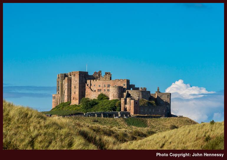
Before travelling onward from Berwick by bus, I took the chance to potter around the place in the morning sunshine, peering at its bridges as I did so. Then, it was time to continue to Bamburgh where its castle awaited. It did not take long to find once there since Bamburgh is not at all large and it is situated atop a hillock.
Rather than going into see the castle on a wonderful sunny day, I opted to stroll around it instead. First, I headed a little south along the road and crossed to the beach through grassy dunes. Only the faded colours of the grasses gave any hint that this was autumn and not summer. Given where the sun was at the time, this also was the best vantage point for photos with good lighting and I was to find that the usual photos that you see published need to be made at another time of day, more likely morning.

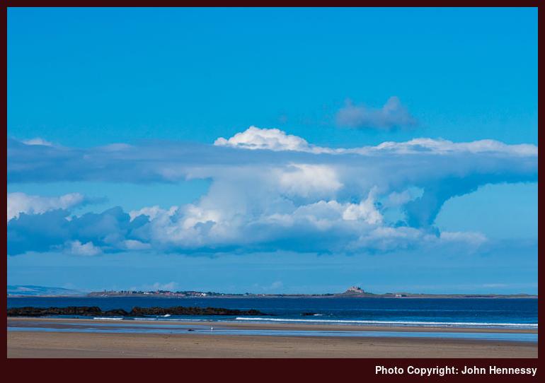
It was when I got onto the beach that I was to discover that last fact, but there were other sights to see. In hindsight, it might have been better to have had a camera with a telephoto lens for some of these. Even capturing views of the Inner Farne would have been helped but it was the more distant ones of a well lit Lindisfarne where the usefulness really would have been seen. Still, it was good to get what I got and to savour what lay about me anyway.
It was around Harkess Rocks where I was to see the classic view of Bamburgh Castle and realise that this was not the time for my own version of such an image. It was no disappointment given what I had got from the day already and I was about to rejoin the Northumberland Coast Path that was set to carry me all the way to Belford.
That conveyed me around the coast as far as Budle Bay while largely avoiding the Bamburgh Castle Golf Club course before I was directed inland towards the B1342. That gave me a chance to look back at the castle where my walk began and it had fallen into cloud shadow. Since I was to head downhill from Galliheugh Bank, this was to be my last sighting for the day.

The sea was not to be seen much as I headed for Spindlestone Heughs by footpath and road. Near Outchester, I got to see more of the sea again, but there also was a curiosity in the form of an old windmill called the Outchester Ducket. The word "ducket" is a local form of dovecot, so that makes the name an unusual one for what is now a building let out as tourist accommodation.
Passing Outchester Farm led me along quiet roads and public rights of way towards the East Coast Mainline that I had to cross to reach Belford. Rather than over a bridge as might be found on the West Coast Mainline, this crossing went straight across the tracks, a striking thought given the chance of an accident. Before making my crossing, I used the provided phone to check if I could cross and did the same on the other side to let them know that I was safely across. The latter was as much for the sake of courtesy as anything else.
After that, Belford was near at hand under cloudy skies with more industrial surroundings for company for much of the last stretch of what had been a pleasing walk with much bright sunshine. It is how Bamburgh Castle and how the nearby coastline looked in the sun that is what I remember. It was a much-needed interlude of brightness in a life with a lot that was happening.
Travel Arrangements
Train journey from Macclesfield to Newcastle with an overnight stop before continuing by train from Newcastle to Berwick-upon-Tweed. Outbound bus journey from Berwick-upon-Tweed to Bamburgh followed by a return bus journey from Belford to Berwick-upon-Tweed before going from there to Macclesfield.