Category: Long Distance Trails
Pennine Way adventures in the Yorkshire Dales: Part 1
Easter Sunday saw me tackle the section of the Pennine Way between Horton-in-Ribblesdale and Hawes. It is mostly on good tracks through open country with big skies. That the day itself was sun-drenched added to the enjoyment.
Transport to Horton didn't work to plan and could have derailed the proceedings. Rail engineering works between Leeds and Shipley meant that trains were replaced by coaches and we ended up with a coach driver who didn't know where he was going. That he turned up late as well didn't help matters either. The result was that those on the coach wanting to proceed to stations on the Settle-Carlisle railway missed our connection. As you can imagine, there was a spot of confusion before we ended up on a train to Skipton from where taxis got us to our destinations; information screens didn't aid our cause either.
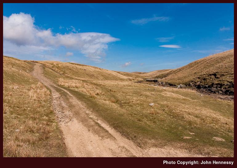
The Sunday morning laggardness with transport made my start from Horton an hour later than planned, but that wasn't to make much of a difference to my enjoyment of the day at all. From the YDNP car park, I made my way onto the track that was to carry me on towards Birkwith Moor and there were ample views of glorious Three Peaks country. In its vicinity, the Pennine Way leaves the track to pick up another near Old Ing. Between tracks, a very nice reconstructed path performs the honours with suitable deterrents for those wanting to take wheeled transport over it.
From Old Ing, another track drops you into Ling Gill nature reserve (I took a spot of lunch between these points with a view of the Ribblehead Viaduct in the distance and the rest was welcome too) before you are hauled out again to join the rutted High Cam Road at Cam End. I very soon encountered the reason for the ruts: green lane enthusiasts with their off-road vehicles.
While I was unsure as to the legality of their enterprise, I left them be rather than starting a futile one-man protest against it. Seeing people driving vehicles at little more than walking speed does make me wonder at what they get out of their pursuit when walking would be more carefree.
Eventually, my wandering took me on to a tarmac road before I left that for yet another track, one without ruts this time. However, while I should have been enjoying the delights of the sights below, a strong wind began to harry me. With the shelter of a stone wall, things weren't too bad but it didn't last. Care was required so that I didn't get blown over and this was at 500–600 metres above sea level. I'd hate to think what things would have been like higher up. It was with some relief that I left that track to continue on the Pennine Way as it descended to the Hawes on the floor of Wensleydale; the breeze was then at my back until the hills started to offer some shelter. Eventually, I encountered Gayle and wound my way on to Hawes.
I reached Hawes at around 17:30 after a ca. 11:00 departure from Horton, so good progress was made. If things had gone to plan with the trip to Horton, I might even have caught a bus taking me all the way back to Leeds. Instead, I had an hour to kill in a pleasant Yorkshire town until a bus took me to Northallerton for an onward train journey; sadly too short for a meal in a pub or even for a fish supper at the chippy. The slow service of the latter and its vibrant trade ensured that I didn't succumb to any temptations. It was a matter of finding a quiet corner and relaxing in the sunshine after a wonderful day; finding the right bus stop in the town's marketplace was also a priority, but that wasn't to prove too painful. The next phase of my Pennine Way adventures from here might allow me to sample more of Hawes' delights, yet that's for the future.
A less than perfect Pennine day
I was out and about yesterday completing the section of the Pennine Way between Marsden and Littleborough. However, as if to scold me for leaving it for later, the hills shrouded themselves in clag that wasn't to budge until I had reached the crossing over the M62. It's an eerie experience following a path while only having visibility for several metres around you: thoughts of the results of a misnavigation were hardly enjoyable. Thankfully, the Pennine Way offers a good clear track to follow, and any navigational questions were quickly resolved with inspection of a map; if it hadn't been like that, turning back would have been the best option. Needless to say, views of the surrounding countryside weren't on offer, so another day in the area is a must if I want to savour what I missed. Yesterday also brought firmly home to me how tricky road crossings become in heavy fog; I rated every safe road crossing as an achievement until the air cleared: the crossing of the A62 at Standedge required particular care due to the lack of visibility and a foggy A672 more so.
Things actually started out looking well. Marsden was enjoying bright sunshine, so there was some hope that the clag lying on the hills might go away. The sun stayed out as I picked up the Kirklees Way that was to take me on to the Pennine Way. The latter has been rerouted so you no longer cross the dam of the Wessenden reservoir; having gone and had a look at why, it seems that the risk of land slippage is at the heart of this change and it does add a descent/ascent that would otherwise have been avoided. Nevertheless, the diversion does seem to an overly cautious move; crossing the slopes of the Craigmichen Scar on the Southern Upland looks much more hazardous in comparison. Another observation is that the route change has yet to make it into the Trailblazer and Cicerone guides to the Pennine Way.
It was after this point that the clag was encountered and it remained like so until I crossed the M62. However, it also seems that the veil of fog was plaguing other places as well; Cheshire was also blighted by it until after lunchtime as Alan Sloman's Big Walk blog records. As it happened, it was about this time that I reached the M62 crossing, and things then started to cheer up considerably and there was a wonderful end to the day. Views of Rishworth Moor and Blackstone Edge were in ample supply. After crossing the latter, the gritstone boulder fields caused a mad navigational moment that I would not relish happening in heavy clag. The result was a pleasant diversion round by Blackstone Edge Reservoir that would have been even better if pylons weren't stalking their way across the countryside. Nevertheless, I quickly knew where I was and took a pleasant path down to Littleborough from the White House pub (I'm keeping that landmark in mind for telling the driver of the Halifax bus where to stop on any future visit).
From Littleborough, the journey home was straightforward: train to Manchester Victoria, crossing to Manchester Piccadilly by Metrolink tram and on foot (the Bury-Altrincham one that I caught didn't call at Piccadilly; something to bear in mind for the future...), train to Macclesfield. The outbound journey was similarly uneventful, the main difference from the return journey being the train from Manchester Victoria to Marsden (it had a non-functioning toilet but we won't dwell on that...).
After my day out, I now have some ideas for future visits. One of these is a circular walk taking in Blackstone Edge and Green Withens Reservoir; it looks a good one for a sunny day. Then there's the matter of savouring the countryside swallowed up in all that clag. One option is a point-to-point walk from Littleborough to Marsden on a route labelled the Station to Station Walk, perhaps taking a diversion along the Pennine Way and the Kirklees Way for the final approach to Marsden. Both are appealing options and could turn what was at times a frustrating day, before its blossoming into a superb evening, into further good ones.

One or more cruxes of the Pennine Way
Upon pondering my progress along the Pennine Way, I started to look at how things might pan out from a logistical point of view, the further north that I continued. Once the section between Littleborough and Marsden is out of the way (hopefully soon), things extend beyond the realm of the day trip and overnight stays, weekend trips even, become a necessity. The land also gets wilder as you continue north, a joy for the hill walker but a challenge for users of public transport like me. And unfamiliarity with an area adds to that. Because I have been that way more than a few times, the Yorkshire Dales sections shouldn't prove to be too much trouble until I get beyond Ribblesdale. Hawes, Thwaite and Keld will be new to me but that's an attraction in itself, seeing new places and enjoying scenery afresh. It will also mean exploring the transport options and they seem to extend from the east. The same applies to Teesdale though Dufton is accessible from the Settle-Carlisle railway, at least on foot. Between Alston and Bellingham, the Newcastle-Carlisle railway and assorted bus connections help access to Alston, Hadrian's Wall and around. Beyond Bellingham, things require even more care with Byrness having limited transport options though they do suffice with good planning.
However, all that still leaves a 27 mile section before Kirk Yetholm is reached. There are mountain refuges along the way so purchasing a lightweight sleeping bag such as PHD's Minimus or Piqolo has come to mind. I also got to wondering if there were any ways to split the marathon journey into more manageable chunks, especially as I am not trying to do the entire Pennine Way in one go. That this is not straightforward becomes obvious when one peruses a map; as one goes north along what becomes the Scotland-England border, the sparsely populated Scottish side is evident to the left and it is a good distance to habitation on the English one. For example, crossing the Cheviot from Wooler and continuing from there is next to a twenty mile day. Ingram and the hamlets of Upper Coquetdale (accommodation is provided in Alwinton and Harbottle but it does not come cheap) may help but long walk-ins are involved from these too. This is wild country all right and I believe it to be the crux of the Pennine Way so that overnight stay in a refuge seems to be the best way to overcome it. Anything has to be better than a one day (up to 14 hours walking at my speed) marathon.
Proceeding beyond Calderdale
Sunday was forecast to be dry and sunny, so it was a matter of seizing the opportunity and deciding where to walk. In the end, I plumped for the continuation of my Pennine Way adventure. I left the section between Littleborough and Marsden for another day and tackled the section between Burnley and Haworth. However, I actually did my walk in the reverse direction due to public transport logistics. In fact, when I was first drafting this post, it was fast becoming a public transport rant so that was put elsewhere so as not to ruin an account of what in fact was a pleasant walk, and it is the walking that I will always remember rather than any transport frustrations. I once had a planned trip to Wales scuppered by a train cancellation, so I headed up to the Lake District, and it is the memorable evening in the company of the likes of Loughrigg Fell, Grasmere and Rydal Water of which I will always have the strongest recollections. That was far from being a disappointing day.
Getting away involved catching the first bus from Macclesfield to Manchester. From there, the railway got me to Keighley with changes at Leeds and Shipley and another bus got me to Haworth. I suppose that I could have travelled on the Keighley and Worth Valley railway, but I stuck with my original plan, even if I caught a Transdev Keighley & District bus for the last leg with only moments left to its departure.
Haworth is certainly a charming spot, but it is not its rustic appeal that attracts the visitors; that is its Brontë connections. Unfortunately, I didn't have the time to linger there, yet there was enough Brontë-this, Brontë-that and Brontë-the-other to give me the general idea. In fact, the Brontë theme was to pervade for a lot of my walk.
It took longer to find than it ought to have done, but I picked up the Brontë Way and followed it until I left it to join the Pennine Way just east of Upper Heights farm. On my journey to that point, I had ambled over Penistone Hill and crossed the Brontë bridge at the foot of the Brontë Falls. Yes, there is a danger of Brontë overload here, and I wasn't finished yet. My trot up the Pennine Way was to take me to Top Withins, the site of the ruins of which is supposed to have inspired the fictional Wuthering Heights in the eponymous novel. There is a plaque erected here by the Brontë Society declaring to the same effect.
I left the literary connections after Top Withins to continue into wild country with broad moorland and big skies. There were wind turbines on the horizon, but I didn't care, though I normally carry strong reservations about the siting of the things. It was not long until I was in reservoir country again; on the way out of Haworth I passed Lower Laithe Reservoir and caught a glimpse of Ponden Reservoir, by which a future northbound Pennine Way excursion would take me. Now I was encountering the Walshaw Dean reservoirs, whose company I would have almost until I met the next public road. By now, the evening light was glorious, and I had to stop myself becoming engrossed in photographic exploits at the expense of my getting home that night; I think that I may have a photo that tries to portray Walshaw Dean Middle Reservoir as if it were a natural lake rather than the man-made construction that it is.

The nearest public road saw me leave the Pennine Way at the spot where I left it on my previous visit to the area, and I was to retread my footsteps on part of the Mary Townley Loop of the Pennine Bridleway until I reached Worsthorne. More reservoirs (Widdop, Gorple Lower, Gorple Upper, Hurstwood; yes, there are a lot around here all right) were passed on what was a surprisingly fleet-footed trek to Worsthorne, a village with a pleasant atmosphere on the edge of Burnley.
Worsthorne proved to be the end of the walking adventure for the day, but my travelling continued. A useful Transdev Burnley & Pendle service carried me to Burnley bus station. My journey continued from Burnley by train to Crewe, with a change in Preston. From Crewe, another bus got me home. It might be better if I had less waiting to do, then I would have got home an hour earlier, but it was a still a satisfactory end to a satisfying day.
Postscript: This was also the first hill day for my new Osprey Atmos pack, and it seems to have performed well. Apart from a little soreness at the end of the day, my back is none the worse and my shoulders were spared the usual torment applied to them by its Eurohike predecessor. So, a little more breaking in, and it looks as if this one will go on and on. I'll just have to try to stop it getting too muddy...
Calderdale revisited
For some reason, the West Yorkshire Metro calls the railway that passes through Calderdale the Caldervale Line; it's enough to confuse the likes of me. However, the local authority is Calderdale MBC and so it is Calderdale to me then.
Anyway, let's get away from the nomenclature and back to some walking. Last week, I was feeling a little burnt out, so I took Friday off to recharge my batteries in the hills around Calderdale. Taking in another section of the Pennine Way was also on the agenda.
An early morning departure from Macclesfield got me as far as Manchester Piccadilly station, from where I used the Metrolink to get to Manchester Victoria station. From Victoria, I caught a train to Todmorden. The timings were a little finer than I would have liked, but the departure from Victoria was delayed by 10 minutes due to its needing some attention; for once, a train was late when I wanted it to be that way.
Once in Todmorden, the walking started in earnest, and in glorious sunshine too. The Calderdale Way and the Pennine Bridleway took me from the heart of Todmorden onto Lumbutts and Mankinholes before rounding Stoodley Pike to pick up the Pennine Way. At this point, my previous hike in the area took me south on my way to Littleborough. This time around, I headed north and descended to the A646 at Charlestown. The only problem with mid-walk descents is that ascents usually follow, and the one from the A646 did take its toll on my legs as I continued on my northward trajectory. My amble continued with a spot of road crossing as I skirted Heptonstall on my way to and through Colden. There was a bit of down and up as I neared Colden, but I did take the chance for a spot of lunch by the stream that caused it. A pub wasn't far away either, if I felt so inclined.
Beyond Colden, the Pennine Way regained its wild feel after its passage through what is a very much inhabited and post-industrial area. The section around Heptonstall Moor was one of the most enjoyable of the whole walk, the only fly in the ointment being the cloud that was bubbling up in the sky. Eventually, I neared the Gorple Lower Reservoir and followed the Pennine Way as it dropped into the gorge carved out by Graining Water until it clambered out onto the nearest minor road. From here, the Pennine Way continues east, and it was at this point that I left it for the Pennine Bridleway, the trail that was to take me onto Worsthorne and Burnley.
I continued up the road and took the track around the shores of Widdop Reservoir, stopping for another food break along the way. After being dull for an hour, the day began to cheer up as I left Widdop, and it largely continued that way for the rest of my walk. On my journey, I continued past views of gritstone outcrops and Gorple Upper Reservoir. The final stretch to Worsthorne took me past Hurstwood Reservoir, with views over Burnley on the descent. Once on tarmac, things began to feel like a slog and I broke my walk into Burnley town centre when I encountered the bus that returned me to Todmorden, a welcome sight. Once in Todmorden, I commenced my railway journey upon the arrival of the next service to Manchester, delayed due to technical problems in Leeds. After that, it was the reverse of my journey that morning.
Though tired after the long day, the walk was good, and it has far from dimmed my appetite for future Pennine Way strolls. Immediate options are the section that starts near Littleborough and gets you near to Marsden, with other footpath options doing the connection honours. Continuing northward, perhaps onto Keighley or beyond on the next stretch, remains a very tempting possibility.
